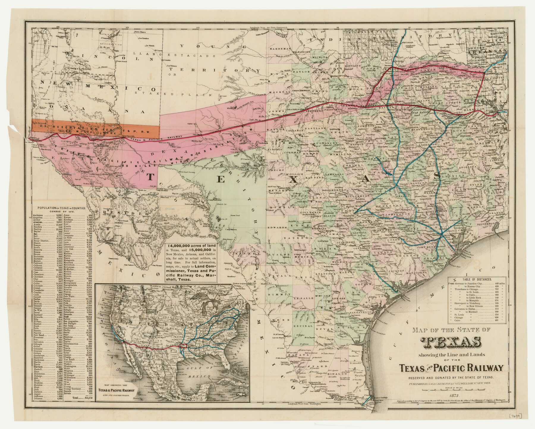
Map of the State of Texas showing the Line and Lands of the Texas and Pacific Railway Reserved and Donated by the State of Texas
-
Map/Doc
76317
-
Collection
Texas State Library and Archives
-
Object Dates
1873 (Creation Date)
-
People and Organizations
G. W. and C. B. Colton and Company (Publisher)
-
Subjects
Railroads State of Texas Texas and Pacific Railroad
-
Height x Width
20.2 x 25.1 inches
51.3 x 63.8 cm
-
Comments
Prints available courtesy of the Texas State Library and Archives.
More info can be found here: TSLAC Map 07699
Part of: Texas State Library and Archives
General Highway Map, Presidio County, Texas

Print $20.00
General Highway Map, Presidio County, Texas
1961
Size 24.5 x 18.3 inches
Map/Doc 79633
General Highway Map. Detail of Cities and Towns in Dallas County, Texas [Dallas and vicinity]
![79070, General Highway Map. Detail of Cities and Towns in Dallas County, Texas [Dallas and vicinity], Texas State Library and Archives](https://historictexasmaps.com/wmedia_w700/maps/79070.tif.jpg)
Print $20.00
General Highway Map. Detail of Cities and Towns in Dallas County, Texas [Dallas and vicinity]
1936
Size 18.4 x 25.1 inches
Map/Doc 79070
General Highway Map, Kleberg County, Texas

Print $20.00
General Highway Map, Kleberg County, Texas
1961
Size 24.8 x 18.3 inches
Map/Doc 79558
Corpus Christi is the Sportsman's Paradise

Print $20.00
Corpus Christi is the Sportsman's Paradise
1942
Size 26.8 x 16.4 inches
Map/Doc 79331
Topographic Map of Big Bend Area

Print $20.00
Topographic Map of Big Bend Area
1923
Size 47.1 x 35.0 inches
Map/Doc 79757
General Highway Map, Hunt County, Texas

Print $20.00
General Highway Map, Hunt County, Texas
1940
Size 25.0 x 18.5 inches
Map/Doc 79136
General Highway Map, Garza County, Texas

Print $20.00
General Highway Map, Garza County, Texas
1940
Size 18.1 x 24.6 inches
Map/Doc 79098
General Highway Map. Detail of Cities and Towns in Cameron County, Texas [San Benito, Harlingen, Brownsville and vicinity]
![79399, General Highway Map. Detail of Cities and Towns in Cameron County, Texas [San Benito, Harlingen, Brownsville and vicinity], Texas State Library and Archives](https://historictexasmaps.com/wmedia_w700/maps/79399.tif.jpg)
Print $20.00
General Highway Map. Detail of Cities and Towns in Cameron County, Texas [San Benito, Harlingen, Brownsville and vicinity]
1961
Size 18.0 x 24.7 inches
Map/Doc 79399
Map of the State of Coahuila and Texas

Print $20.00
Map of the State of Coahuila and Texas
1833
Size 16.1 x 20.2 inches
Map/Doc 76246
General Highway Map, Crane County, Texas

Print $20.00
General Highway Map, Crane County, Texas
1940
Size 25.2 x 18.3 inches
Map/Doc 79061
General Highway Map. Detail of Cities and Towns in Val Verde County, Texas [Del Rio and vicinity]
![79695, General Highway Map. Detail of Cities and Towns in Val Verde County, Texas [Del Rio and vicinity], Texas State Library and Archives](https://historictexasmaps.com/wmedia_w700/maps/79695.tif.jpg)
Print $20.00
General Highway Map. Detail of Cities and Towns in Val Verde County, Texas [Del Rio and vicinity]
1961
Size 18.0 x 24.8 inches
Map/Doc 79695
General Highway Map. Detail of Cities and Towns in Potter County, Texas [Amarillo and vicinity]
![79221, General Highway Map. Detail of Cities and Towns in Potter County, Texas [Amarillo and vicinity], Texas State Library and Archives](https://historictexasmaps.com/wmedia_w700/maps/79221.tif.jpg)
Print $20.00
General Highway Map. Detail of Cities and Towns in Potter County, Texas [Amarillo and vicinity]
1940
Size 24.6 x 18.2 inches
Map/Doc 79221
You may also like
Uvalde County Working Sketch 48

Print $20.00
- Digital $50.00
Uvalde County Working Sketch 48
1980
Size 15.6 x 17.9 inches
Map/Doc 72118
Hidalgo County Sketch

Print $20.00
- Digital $50.00
Hidalgo County Sketch
1903
Size 30.4 x 37.7 inches
Map/Doc 4450
Flight Mission No. DQN-2K, Frame 23, Calhoun County

Print $20.00
- Digital $50.00
Flight Mission No. DQN-2K, Frame 23, Calhoun County
1953
Size 17.4 x 19.3 inches
Map/Doc 84230
Stephens County Sketch File 20

Print $20.00
- Digital $50.00
Stephens County Sketch File 20
Size 19.2 x 36.7 inches
Map/Doc 12350
Upton County Sketch File 10

Print $18.00
- Digital $50.00
Upton County Sketch File 10
1919
Size 13.5 x 8.7 inches
Map/Doc 38839
Yoakum County Sketch File 14

Print $22.00
- Digital $50.00
Yoakum County Sketch File 14
1937
Size 14.5 x 14.6 inches
Map/Doc 40791
Presidio County Rolled Sketch 131A

Print $20.00
- Digital $50.00
Presidio County Rolled Sketch 131A
1992
Size 36.0 x 45.5 inches
Map/Doc 9801
Matagorda County Sketch File 7b

Print $4.00
- Digital $50.00
Matagorda County Sketch File 7b
1890
Size 14.2 x 8.8 inches
Map/Doc 30744
Flight Mission No. DIX-3P, Frame 60, Aransas County

Print $20.00
- Digital $50.00
Flight Mission No. DIX-3P, Frame 60, Aransas County
1956
Size 17.6 x 18.0 inches
Map/Doc 83762
Travis County Sketch File 25

Print $4.00
- Digital $50.00
Travis County Sketch File 25
1876
Size 12.7 x 8.5 inches
Map/Doc 38334
Flight Mission No. DQN-1K, Frame 77, Calhoun County

Print $20.00
- Digital $50.00
Flight Mission No. DQN-1K, Frame 77, Calhoun County
1953
Size 18.5 x 22.2 inches
Map/Doc 84162
Gaines County Sketch File 19

Print $8.00
- Digital $50.00
Gaines County Sketch File 19
1989
Size 11.3 x 8.8 inches
Map/Doc 23331