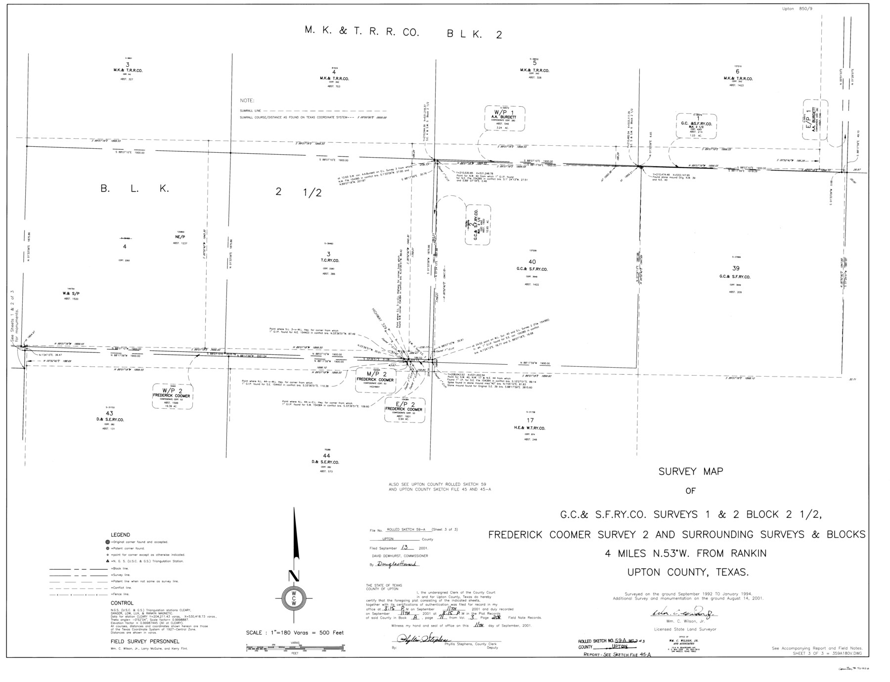
Upton County Rolled Sketch 59A
Survey map of G. C. & S. F. Ry. Co. surveys 1 & 2, Block 2 1/2, Frederick Coomer survey 2 and surrounding surveys & Blocks
-
Map/Doc
76424
-
Collection
General Map Collection
-
Object Dates
2001/8/14 (Survey Date)
2001/9/13 (File Date)
-
People and Organizations
Wm. C. Wilson, Jr. (Surveyor/Engineer)
-
Counties
Upton
-
Subjects
Surveying Rolled Sketch
-
Height x Width
35.5 x 46.3 inches
90.2 x 117.6 cm
-
Medium
mylar, print
-
Scale
1" = 180 varas
-
Comments
Sheet 3 of 3. See Upton County Sketch File 45A (38945) for report.
Related maps
Upton County Sketch File 45A

Print $8.00
- Digital $50.00
Upton County Sketch File 45A
2001
Size 11.3 x 8.8 inches
Map/Doc 38945
Part of: General Map Collection
Brazoria County Sketch File 44

Print $30.00
- Digital $50.00
Brazoria County Sketch File 44
1946
Size 11.3 x 8.9 inches
Map/Doc 15068
Upton County Rolled Sketch 59A

Print $20.00
- Digital $50.00
Upton County Rolled Sketch 59A
Size 35.7 x 45.9 inches
Map/Doc 76423
Webb County Rolled Sketch 5

Print $20.00
- Digital $50.00
Webb County Rolled Sketch 5
Size 43.2 x 23.0 inches
Map/Doc 8172
Controlled Mosaic by Jack Amman Photogrammetric Engineers, Inc - Sheet 28

Print $20.00
- Digital $50.00
Controlled Mosaic by Jack Amman Photogrammetric Engineers, Inc - Sheet 28
1954
Size 21.1 x 24.1 inches
Map/Doc 83480
Menard County Working Sketch 13

Print $20.00
- Digital $50.00
Menard County Working Sketch 13
1939
Size 27.3 x 38.1 inches
Map/Doc 70960
La Salle County Rolled Sketch 10

Print $40.00
- Digital $50.00
La Salle County Rolled Sketch 10
1945
Size 48.1 x 33.5 inches
Map/Doc 6573
La Salle County Sketch File 29a

Print $22.00
- Digital $50.00
La Salle County Sketch File 29a
1886
Size 8.9 x 12.5 inches
Map/Doc 29563
Parker County Sketch File 37

Print $4.00
- Digital $50.00
Parker County Sketch File 37
Size 4.8 x 8.1 inches
Map/Doc 33581
Liberty County Working Sketch 83

Print $40.00
- Digital $50.00
Liberty County Working Sketch 83
1981
Size 68.4 x 37.8 inches
Map/Doc 70543
Robertson Co.

Print $20.00
- Digital $50.00
Robertson Co.
1945
Size 47.9 x 39.0 inches
Map/Doc 63004
Maverick County Sketch File 25

Print $20.00
- Digital $50.00
Maverick County Sketch File 25
1914
Size 18.4 x 25.6 inches
Map/Doc 12055
Knox County Rolled Sketch 9

Print $20.00
- Digital $50.00
Knox County Rolled Sketch 9
Size 26.1 x 33.0 inches
Map/Doc 9407
You may also like
Robertson V Ranch

Print $20.00
- Digital $50.00
Robertson V Ranch
Size 41.7 x 46.0 inches
Map/Doc 89756
Flight Mission No. BRA-16M, Frame 177, Jefferson County

Print $20.00
- Digital $50.00
Flight Mission No. BRA-16M, Frame 177, Jefferson County
1953
Size 18.7 x 22.3 inches
Map/Doc 85775
Flight Mission No. CUG-3P, Frame 40, Kleberg County

Print $20.00
- Digital $50.00
Flight Mission No. CUG-3P, Frame 40, Kleberg County
1956
Size 18.5 x 22.2 inches
Map/Doc 86245
Presidio County Rolled Sketch 63

Print $20.00
- Digital $50.00
Presidio County Rolled Sketch 63
Size 21.6 x 21.3 inches
Map/Doc 7355
Erath County Rolled Sketch 2

Print $20.00
- Digital $50.00
Erath County Rolled Sketch 2
Size 21.0 x 25.9 inches
Map/Doc 5861
Travis County Appraisal District Plat Map 2_2814

Print $20.00
- Digital $50.00
Travis County Appraisal District Plat Map 2_2814
Size 21.6 x 26.4 inches
Map/Doc 94218
Montgomery County Working Sketch 50

Print $20.00
- Digital $50.00
Montgomery County Working Sketch 50
1959
Size 25.3 x 21.9 inches
Map/Doc 71157
Lynn County Boundary File 1

Print $10.00
- Digital $50.00
Lynn County Boundary File 1
Size 14.2 x 8.7 inches
Map/Doc 56617
Flight Mission No. BRA-8M, Frame 66, Jefferson County

Print $20.00
- Digital $50.00
Flight Mission No. BRA-8M, Frame 66, Jefferson County
1953
Size 18.6 x 22.1 inches
Map/Doc 85586
Terrell County Working Sketch 84b

Print $20.00
- Digital $50.00
Terrell County Working Sketch 84b
1992
Size 25.2 x 42.7 inches
Map/Doc 69606
Denton County Sketch File 33

Print $4.00
- Digital $50.00
Denton County Sketch File 33
Size 8.2 x 12.4 inches
Map/Doc 20760
San Patricio County Rolled Sketch 34

Print $20.00
- Digital $50.00
San Patricio County Rolled Sketch 34
Size 25.8 x 26.2 inches
Map/Doc 7584