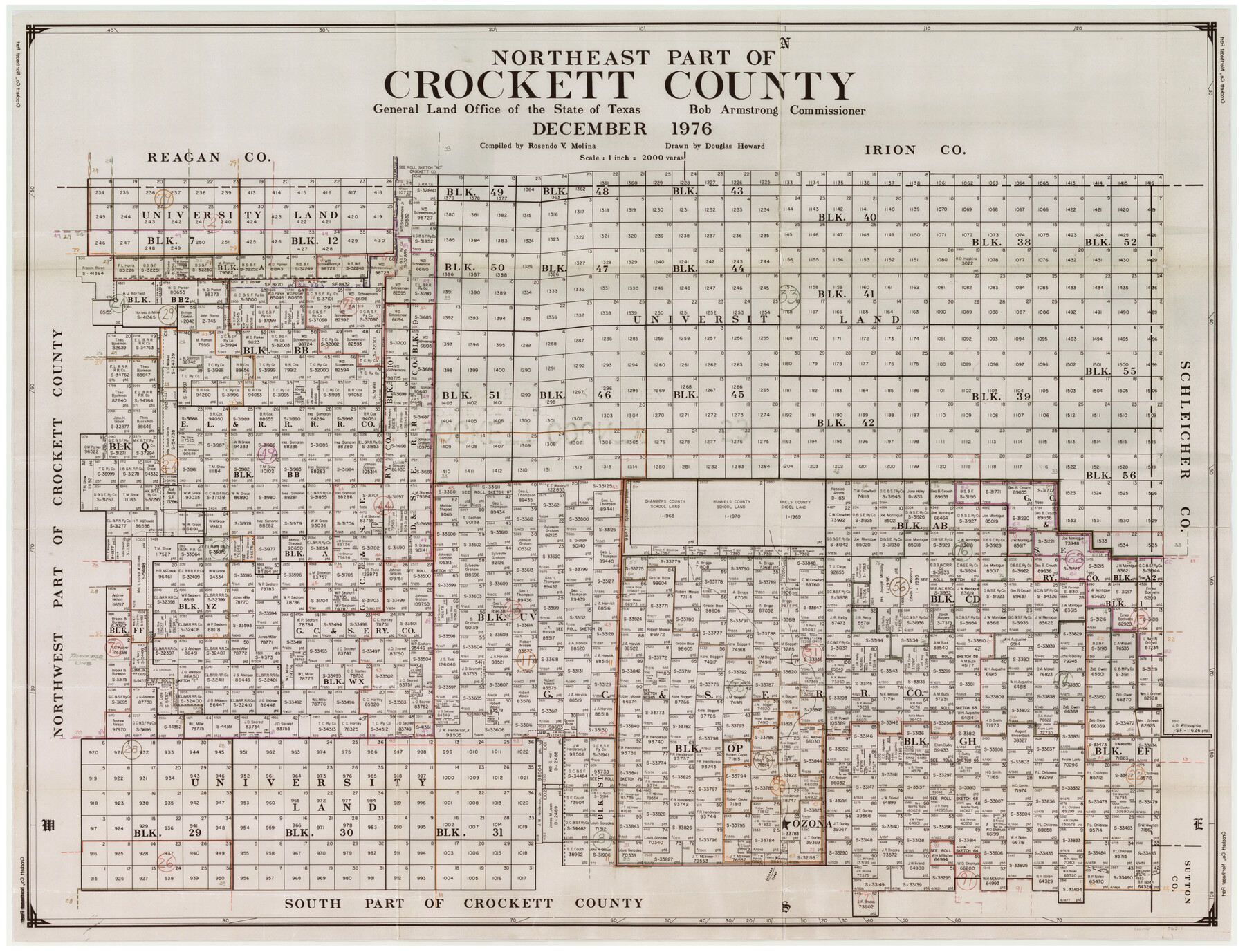
Crockett County Working Sketch Graphic Index - northeast part
-
Map/Doc
76511
-
Collection
General Map Collection
-
Object Dates
12/1976 (Creation Date)
-
People and Organizations
Rosendo V. Molina (Compiler)
Douglas Howard (Draftsman)
-
Counties
Crockett
-
Subjects
County Surveying Working Sketch
-
Height x Width
35.6 x 46.4 inches
90.4 x 117.9 cm
-
Scale
1" = 2000 varas
Part of: General Map Collection
Flight Mission No. CRC-4R, Frame 73, Chambers County

Print $20.00
- Digital $50.00
Flight Mission No. CRC-4R, Frame 73, Chambers County
1956
Size 18.7 x 22.5 inches
Map/Doc 84877
[Surveys near Hondo Creek]
![226, [Surveys near Hondo Creek], General Map Collection](https://historictexasmaps.com/wmedia_w700/maps/226.tif.jpg)
Print $2.00
- Digital $50.00
[Surveys near Hondo Creek]
1847
Size 13.8 x 8.0 inches
Map/Doc 226
Tyler County Rolled Sketch 6

Print $40.00
- Digital $50.00
Tyler County Rolled Sketch 6
1956
Size 76.1 x 43.2 inches
Map/Doc 10029
Pecos County Working Sketch 124

Print $40.00
- Digital $50.00
Pecos County Working Sketch 124
1974
Size 57.9 x 38.2 inches
Map/Doc 71597
Matagorda County

Print $40.00
- Digital $50.00
Matagorda County
1920
Size 41.6 x 49.7 inches
Map/Doc 95582
Bowie County Sketch File 1

Print $8.00
- Digital $50.00
Bowie County Sketch File 1
Size 8.6 x 10.0 inches
Map/Doc 14833
Palo Pinto County Rolled Sketch 8

Print $40.00
- Digital $50.00
Palo Pinto County Rolled Sketch 8
Size 116.4 x 54.6 inches
Map/Doc 9674
Clason's Oil Map of Texas and Oklahoma showing the location and approximate area of the oil and gas fields

Print $20.00
- Digital $50.00
Clason's Oil Map of Texas and Oklahoma showing the location and approximate area of the oil and gas fields
1919
Size 22.4 x 24.5 inches
Map/Doc 97158
Collin County Sketch File 8

Print $4.00
- Digital $50.00
Collin County Sketch File 8
1859
Size 10.2 x 8.1 inches
Map/Doc 18868
Crockett County Sketch File 26

Print $58.00
- Digital $50.00
Crockett County Sketch File 26
1880
Size 8.7 x 7.2 inches
Map/Doc 19706
Gregg County Sketch File 2a

Print $8.00
- Digital $50.00
Gregg County Sketch File 2a
1847
Size 10.1 x 15.9 inches
Map/Doc 24566

You may also like
Erath County Working Sketch 41

Print $20.00
- Digital $50.00
Erath County Working Sketch 41
Size 25.5 x 29.0 inches
Map/Doc 69122
Zavala County Rolled Sketch 30

Print $20.00
- Digital $50.00
Zavala County Rolled Sketch 30
Size 18.6 x 19.1 inches
Map/Doc 8331
Travis County Sketch File 6

Print $8.00
- Digital $50.00
Travis County Sketch File 6
1841
Size 13.8 x 10.9 inches
Map/Doc 38283
Map of the State University & Public School Lands in Reeves and El Paso Cos.

Print $40.00
- Digital $50.00
Map of the State University & Public School Lands in Reeves and El Paso Cos.
1884
Size 39.1 x 56.3 inches
Map/Doc 2434
Dallam County Working Sketch Graphic Index

Print $40.00
- Digital $50.00
Dallam County Working Sketch Graphic Index
1926
Size 41.3 x 50.9 inches
Map/Doc 76516
The Brownsville District of the Famous Lower Rio Grande Valley - The Texas Tropics

The Brownsville District of the Famous Lower Rio Grande Valley - The Texas Tropics
1920
Map/Doc 96732
Collin County Boundary File 18e

Print $16.00
- Digital $50.00
Collin County Boundary File 18e
Size 6.8 x 8.1 inches
Map/Doc 51749
Travis County Working Sketch 13

Print $20.00
- Digital $50.00
Travis County Working Sketch 13
1930
Size 20.5 x 27.3 inches
Map/Doc 69397

McCulloch County Boundary File 1

Print $40.00
- Digital $50.00
McCulloch County Boundary File 1
Size 9.2 x 33.6 inches
Map/Doc 56906
Aransas County Working Sketch 19

Print $20.00
- Digital $50.00
Aransas County Working Sketch 19
1978
Size 25.1 x 31.1 inches
Map/Doc 67186
Survey of Improvements on Meeks Gin Site Town of Ropes Hockley County, Texas

Print $20.00
- Digital $50.00
Survey of Improvements on Meeks Gin Site Town of Ropes Hockley County, Texas
1957
Size 13.0 x 17.6 inches
Map/Doc 92214