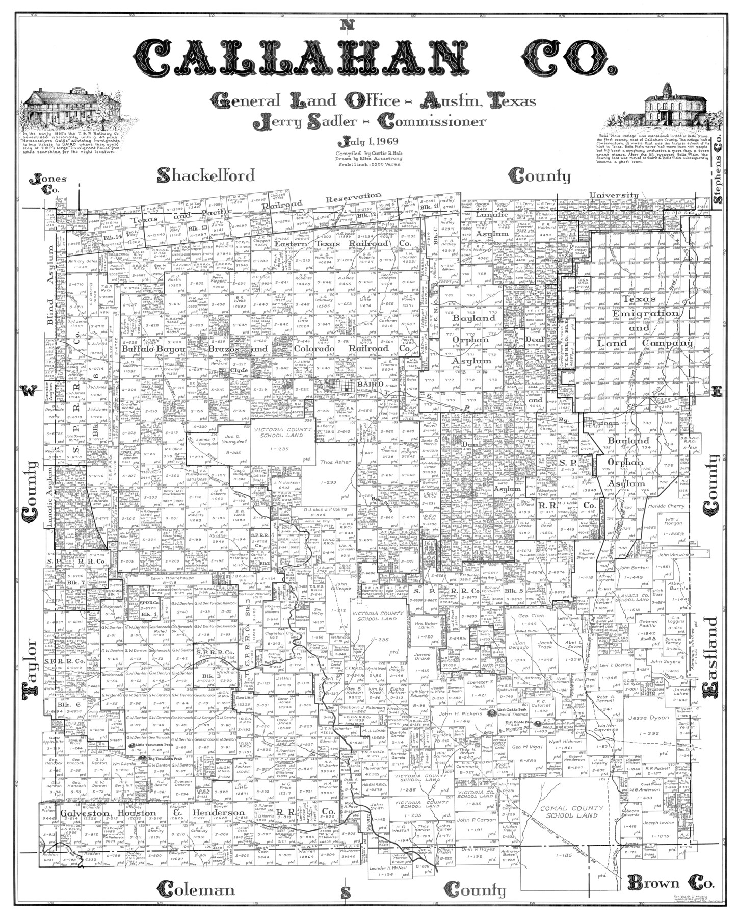
Callahan Co.
-
Map/Doc
77229
-
Collection
General Map Collection
-
Object Dates
1969/7/1 (Creation Date)
-
People and Organizations
Eltea Armstrong (Draftsman)
Curtis R. Hale (Compiler)
-
Counties
Callahan
-
Subjects
County
-
Height x Width
42.0 x 34.5 inches
106.7 x 87.6 cm
Part of: General Map Collection
Flight Mission No. DIX-3P, Frame 139, Aransas County

Print $20.00
- Digital $50.00
Flight Mission No. DIX-3P, Frame 139, Aransas County
1956
Size 17.8 x 18.6 inches
Map/Doc 83769
Map of Comanche County

Print $20.00
- Digital $50.00
Map of Comanche County
1856
Size 22.5 x 29.8 inches
Map/Doc 3432
Flight Mission No. CRE-2R, Frame 157, Jackson County

Print $20.00
- Digital $50.00
Flight Mission No. CRE-2R, Frame 157, Jackson County
1956
Size 18.4 x 22.3 inches
Map/Doc 85368
Johnson County Working Sketch 23

Print $20.00
- Digital $50.00
Johnson County Working Sketch 23
1997
Size 25.3 x 22.8 inches
Map/Doc 66636
Kimble County Working Sketch 39

Print $20.00
- Digital $50.00
Kimble County Working Sketch 39
1947
Size 30.8 x 23.5 inches
Map/Doc 70107
Zavala County Working Sketch 20

Print $20.00
- Digital $50.00
Zavala County Working Sketch 20
1977
Size 40.0 x 34.5 inches
Map/Doc 62095
Coleman County Sketch File 16

Print $4.00
- Digital $50.00
Coleman County Sketch File 16
1849
Size 9.6 x 8.3 inches
Map/Doc 18683
Kendall County Working Sketch 13

Print $20.00
- Digital $50.00
Kendall County Working Sketch 13
1959
Size 25.5 x 30.5 inches
Map/Doc 66685

Harbor Pass and Bar at Brazos Santiago, Texas

Print $20.00
- Digital $50.00
Harbor Pass and Bar at Brazos Santiago, Texas
1879
Size 18.2 x 27.5 inches
Map/Doc 73000
Zapata County Working Sketch 3

Print $20.00
- Digital $50.00
Zapata County Working Sketch 3
1932
Size 18.0 x 13.6 inches
Map/Doc 62054
Map of Wilbarger County

Print $40.00
- Digital $50.00
Map of Wilbarger County
1887
Size 52.2 x 47.0 inches
Map/Doc 16926
You may also like
Childress County Rolled Sketch 9B

Print $20.00
- Digital $50.00
Childress County Rolled Sketch 9B
Size 17.3 x 23.6 inches
Map/Doc 5448
Cameron County Rolled Sketch 13

Print $40.00
- Digital $50.00
Cameron County Rolled Sketch 13
1952
Size 39.2 x 62.1 inches
Map/Doc 8567
The Mexican Municipality of Brazoria. December 28, 1834

Print $20.00
The Mexican Municipality of Brazoria. December 28, 1834
2020
Size 16.5 x 21.7 inches
Map/Doc 96017
Map of El Paso County

Print $20.00
- Digital $50.00
Map of El Paso County
1888
Size 47.1 x 39.5 inches
Map/Doc 4942
Carte Reduite du Globe Terrestre

Print $20.00
- Digital $50.00
Carte Reduite du Globe Terrestre
1782
Size 13.5 x 17.1 inches
Map/Doc 97117
Duval County Sketch File 40a

Print $10.00
- Digital $50.00
Duval County Sketch File 40a
Size 13.9 x 8.8 inches
Map/Doc 21389
Wichita County Sketch File 17

Print $20.00
- Digital $50.00
Wichita County Sketch File 17
1889
Size 29.7 x 22.4 inches
Map/Doc 12680
Colorado County Working Sketch 25

Print $20.00
- Digital $50.00
Colorado County Working Sketch 25
1972
Size 39.1 x 34.2 inches
Map/Doc 68125
[Central Garza County]
![92659, [Central Garza County], Twichell Survey Records](https://historictexasmaps.com/wmedia_w700/maps/92659-1.tif.jpg)
Print $20.00
- Digital $50.00
[Central Garza County]
1906
Size 28.0 x 33.1 inches
Map/Doc 92659
Jones County Rolled Sketch 1

Print $20.00
- Digital $50.00
Jones County Rolled Sketch 1
1957
Size 17.7 x 28.1 inches
Map/Doc 6451
Kendall County Working Sketch 18

Print $20.00
- Digital $50.00
Kendall County Working Sketch 18
1970
Size 43.2 x 33.3 inches
Map/Doc 66690
Val Verde County Sketch File XXX9

Print $4.00
- Digital $50.00
Val Verde County Sketch File XXX9
Size 11.0 x 8.5 inches
Map/Doc 39108