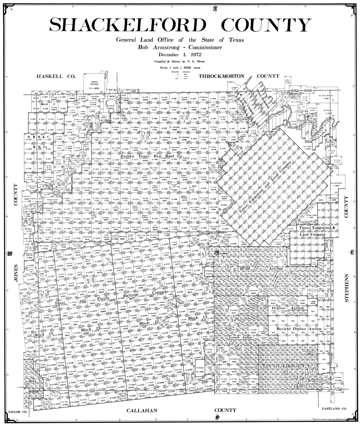
Shackelford County
-
Map/Doc
77420
-
Collection
General Map Collection
-
Object Dates
1972/12/1 (Creation Date)
-
People and Organizations
Crockett L. Slover (Draftsman)
Crockett L. Slover (Compiler)
-
Counties
Shackelford
-
Subjects
County
-
Height x Width
41.1 x 35.0 inches
104.4 x 88.9 cm
Part of: General Map Collection
Map of Comal County

Print $20.00
- Digital $50.00
Map of Comal County
1879
Size 19.3 x 25.7 inches
Map/Doc 4521
Lynn County Sketch File 14

Print $12.00
- Digital $50.00
Lynn County Sketch File 14
1916
Size 14.1 x 8.7 inches
Map/Doc 30491
Lampasas County

Print $20.00
- Digital $50.00
Lampasas County
1972
Size 33.2 x 41.9 inches
Map/Doc 77347
DeWitt County Sketch File 8

Print $4.00
- Digital $50.00
DeWitt County Sketch File 8
1876
Size 8.5 x 5.2 inches
Map/Doc 20818
Val Verde County Sketch File XXX3

Print $6.00
- Digital $50.00
Val Verde County Sketch File XXX3
Size 11.0 x 16.8 inches
Map/Doc 39096
[Military surveys on headwaters of Red River]
![3099, [Military surveys on headwaters of Red River], General Map Collection](https://historictexasmaps.com/wmedia_w700/maps/3099-1.tif.jpg)
Print $20.00
- Digital $50.00
[Military surveys on headwaters of Red River]
1878
Size 31.6 x 39.0 inches
Map/Doc 3099
Travis County Appraisal District Plat Map 2_0404

Print $20.00
- Digital $50.00
Travis County Appraisal District Plat Map 2_0404
Size 21.5 x 26.4 inches
Map/Doc 94229
Gregg County Sketch File 1A

Print $6.00
- Digital $50.00
Gregg County Sketch File 1A
1847
Size 8.3 x 7.6 inches
Map/Doc 24535
Flight Mission No. BRA-7M, Frame 206, Jefferson County

Print $20.00
- Digital $50.00
Flight Mission No. BRA-7M, Frame 206, Jefferson County
1953
Size 18.6 x 22.2 inches
Map/Doc 85574
Cooke County Boundary File 20

Print $88.00
- Digital $50.00
Cooke County Boundary File 20
Size 3.2 x 8.6 inches
Map/Doc 51873
Map of Palo Pinto County, east of the Brazos River, Robertson - west of it, Milam Land District

Print $20.00
- Digital $50.00
Map of Palo Pinto County, east of the Brazos River, Robertson - west of it, Milam Land District
1859
Size 27.4 x 22.3 inches
Map/Doc 3935
Newton County Working Sketch 13

Print $20.00
- Digital $50.00
Newton County Working Sketch 13
1946
Size 34.4 x 34.2 inches
Map/Doc 71259
You may also like
Crosby County Sketch File 27

Print $20.00
- Digital $50.00
Crosby County Sketch File 27
Size 8.8 x 23.0 inches
Map/Doc 11256
Foard County Rolled Sketch 15A

Print $20.00
- Digital $50.00
Foard County Rolled Sketch 15A
1889
Size 37.5 x 36.1 inches
Map/Doc 8339
Map of Coryell County

Print $20.00
- Digital $50.00
Map of Coryell County
1855
Size 22.5 x 23.0 inches
Map/Doc 3447
Blanco County Sketch File 31

Print $4.00
- Digital $50.00
Blanco County Sketch File 31
Size 11.1 x 8.6 inches
Map/Doc 14629
Cottle County Sketch File KN

Print $20.00
- Digital $50.00
Cottle County Sketch File KN
Size 18.8 x 25.2 inches
Map/Doc 11203

Bandera County Working Sketch 18

Print $20.00
- Digital $50.00
Bandera County Working Sketch 18
1946
Size 25.6 x 26.5 inches
Map/Doc 67614
Reagan County Rolled Sketch 10

Print $20.00
- Digital $50.00
Reagan County Rolled Sketch 10
1939
Size 18.7 x 15.8 inches
Map/Doc 7438
[F. W. & D. C. Ry. Co. Alignment and Right of Way Map, Clay County]
![64725, [F. W. & D. C. Ry. Co. Alignment and Right of Way Map, Clay County], General Map Collection](https://historictexasmaps.com/wmedia_w700/maps/64725-1.tif.jpg)
Print $20.00
- Digital $50.00
[F. W. & D. C. Ry. Co. Alignment and Right of Way Map, Clay County]
1927
Size 18.6 x 11.7 inches
Map/Doc 64725
Borden County Boundary File 3

Print $62.00
- Digital $50.00
Borden County Boundary File 3
1908
Size 28.7 x 82.9 inches
Map/Doc 1695
Hardin County Working Sketch 21

Print $20.00
- Digital $50.00
Hardin County Working Sketch 21
1947
Size 43.2 x 38.4 inches
Map/Doc 63419
Working Drawing Compiled from Field Notes of the Sand Hills Area - Crane Co. Tex.

Print $20.00
- Digital $50.00
Working Drawing Compiled from Field Notes of the Sand Hills Area - Crane Co. Tex.
Size 43.5 x 30.8 inches
Map/Doc 90461