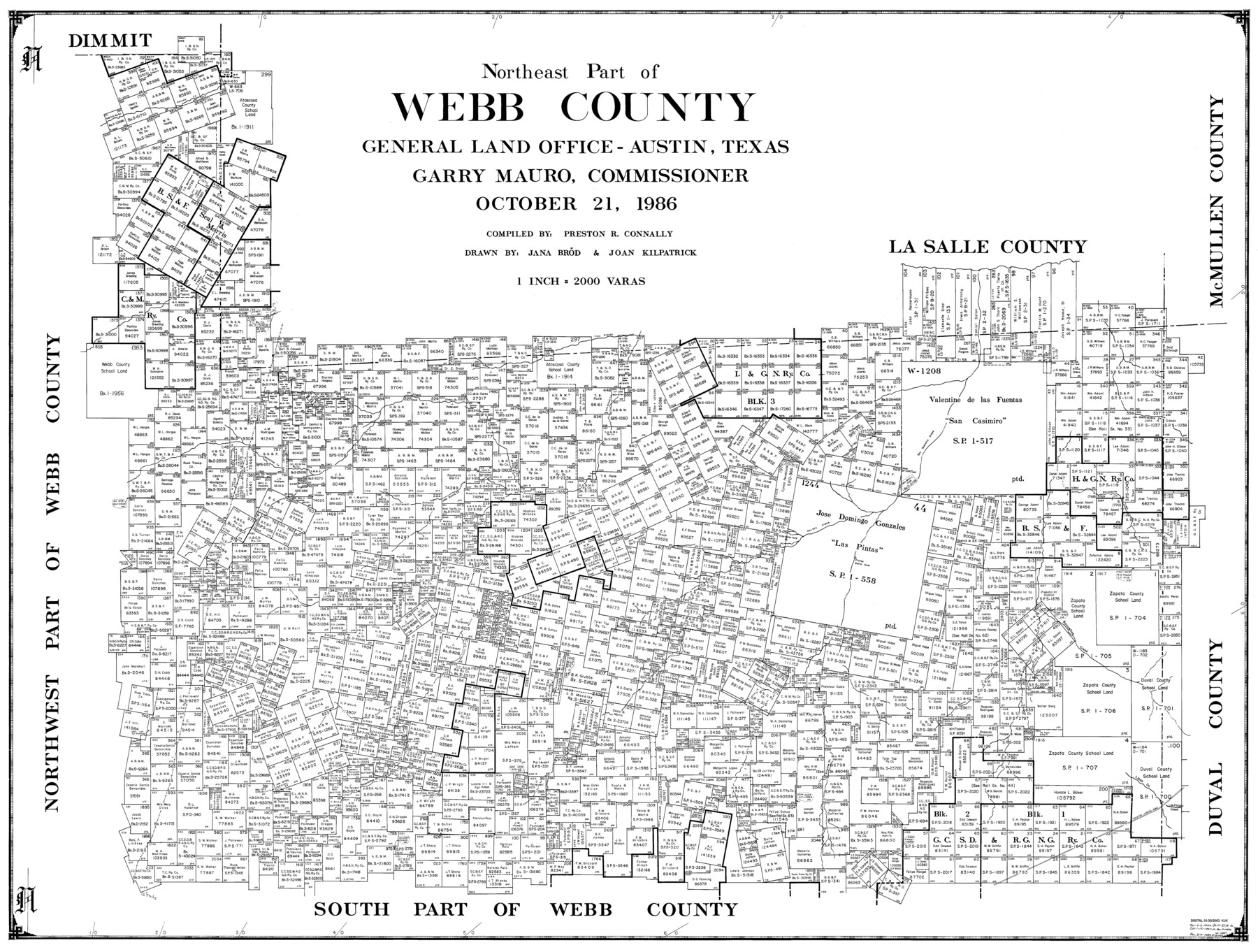
Northeast Part of Webb County
-
Map/Doc
77452
-
Collection
General Map Collection
-
Object Dates
10/21/1986 (Creation Date)
-
People and Organizations
Jana Brod (Draftsman)
Preston R. Connally (Compiler)
Joan Kilpatrick (Draftsman)
-
Counties
Webb
-
Subjects
County
-
Height x Width
34.6 x 45.7 inches
87.9 x 116.1 cm
-
Scale
1" = 2000 varas
Part of: General Map Collection
Childress County Rolled Sketch 18A

Print $20.00
- Digital $50.00
Childress County Rolled Sketch 18A
1913
Size 18.5 x 39.8 inches
Map/Doc 5452
Dimmit County Sketch File 44

Print $20.00
- Digital $50.00
Dimmit County Sketch File 44
Size 16.3 x 19.5 inches
Map/Doc 11354
Jack County Sketch File 37

Print $4.00
- Digital $50.00
Jack County Sketch File 37
1963
Size 3.5 x 7.6 inches
Map/Doc 27615
Chambers County Working Sketch 25

Print $20.00
- Digital $50.00
Chambers County Working Sketch 25
1980
Size 16.6 x 28.5 inches
Map/Doc 68008
Map of the State University & Public School Lands in Reeves and El Paso Cos.

Print $40.00
- Digital $50.00
Map of the State University & Public School Lands in Reeves and El Paso Cos.
1884
Size 39.1 x 56.3 inches
Map/Doc 2434
[Surveys in Milam District between the Bosque and Brazos Rivers]
![3, [Surveys in Milam District between the Bosque and Brazos Rivers], General Map Collection](https://historictexasmaps.com/wmedia_w700/maps/3.tif.jpg)
Print $20.00
- Digital $50.00
[Surveys in Milam District between the Bosque and Brazos Rivers]
1847
Size 15.8 x 12.2 inches
Map/Doc 3
Flight Mission No. BRA-8M, Frame 141, Jefferson County

Print $20.00
- Digital $50.00
Flight Mission No. BRA-8M, Frame 141, Jefferson County
1953
Size 18.8 x 22.4 inches
Map/Doc 85633
Baylor County Sketch File 21

Print $40.00
- Digital $50.00
Baylor County Sketch File 21
Size 17.5 x 30.7 inches
Map/Doc 10908
Harris County Historic Topographic B

Print $20.00
- Digital $50.00
Harris County Historic Topographic B
1916
Size 25.5 x 19.2 inches
Map/Doc 65850
Austin County Sketch File 8

Print $40.00
- Digital $50.00
Austin County Sketch File 8
1894
Size 19.3 x 19.9 inches
Map/Doc 10873
Cherokee County Sketch File 33

Print $16.00
- Digital $50.00
Cherokee County Sketch File 33
1935
Size 11.5 x 7.2 inches
Map/Doc 18190
Galveston County NRC Article 33.136 Sketch 30

Print $20.00
- Digital $50.00
Galveston County NRC Article 33.136 Sketch 30
2005
Size 12.1 x 15.5 inches
Map/Doc 82997
You may also like
Flight Mission No. CRC-1R, Frame 34, Chambers County

Print $20.00
- Digital $50.00
Flight Mission No. CRC-1R, Frame 34, Chambers County
1956
Size 18.8 x 22.4 inches
Map/Doc 84702
Glasscock County Sketch File 3

Print $3.00
- Digital $50.00
Glasscock County Sketch File 3
1931
Size 11.1 x 14.8 inches
Map/Doc 11560
Jeff Davis County Working Sketch 3

Print $20.00
- Digital $50.00
Jeff Davis County Working Sketch 3
1914
Size 17.8 x 16.9 inches
Map/Doc 66498
Coke County Rolled Sketch 18

Print $20.00
- Digital $50.00
Coke County Rolled Sketch 18
Size 43.4 x 34.4 inches
Map/Doc 8632
[Sketch for Mineral Applications 26885-6 - Reagan and Crockett Cos., W. H. Bland]
![65671, [Sketch for Mineral Applications 26885-6 - Reagan and Crockett Cos., W. H. Bland], General Map Collection](https://historictexasmaps.com/wmedia_w700/maps/65671-1.tif.jpg)
Print $40.00
- Digital $50.00
[Sketch for Mineral Applications 26885-6 - Reagan and Crockett Cos., W. H. Bland]
Size 37.3 x 51.0 inches
Map/Doc 65671
Bee County Sketch File 1a

Print $12.00
- Digital $50.00
Bee County Sketch File 1a
1846
Size 9.8 x 6.5 inches
Map/Doc 14359
Ector County Rolled Sketch 15

Print $20.00
- Digital $50.00
Ector County Rolled Sketch 15
1987
Size 47.5 x 36.6 inches
Map/Doc 8842
Pecos County Working Sketch 131

Print $20.00
- Digital $50.00
Pecos County Working Sketch 131
1977
Size 27.8 x 21.1 inches
Map/Doc 71605
Sutton County Boundary File 3

Print $22.00
- Digital $50.00
Sutton County Boundary File 3
Size 14.2 x 8.7 inches
Map/Doc 59024
The Republic County of Gonzales. December 29, 1845

Print $20.00
The Republic County of Gonzales. December 29, 1845
2020
Size 14.7 x 21.7 inches
Map/Doc 96160
Flight Mission No. BRE-1P, Frame 75, Nueces County

Print $20.00
- Digital $50.00
Flight Mission No. BRE-1P, Frame 75, Nueces County
1956
Size 18.4 x 22.2 inches
Map/Doc 86657
Palo Pinto County, Texas

Print $20.00
- Digital $50.00
Palo Pinto County, Texas
1871
Size 28.8 x 23.4 inches
Map/Doc 660