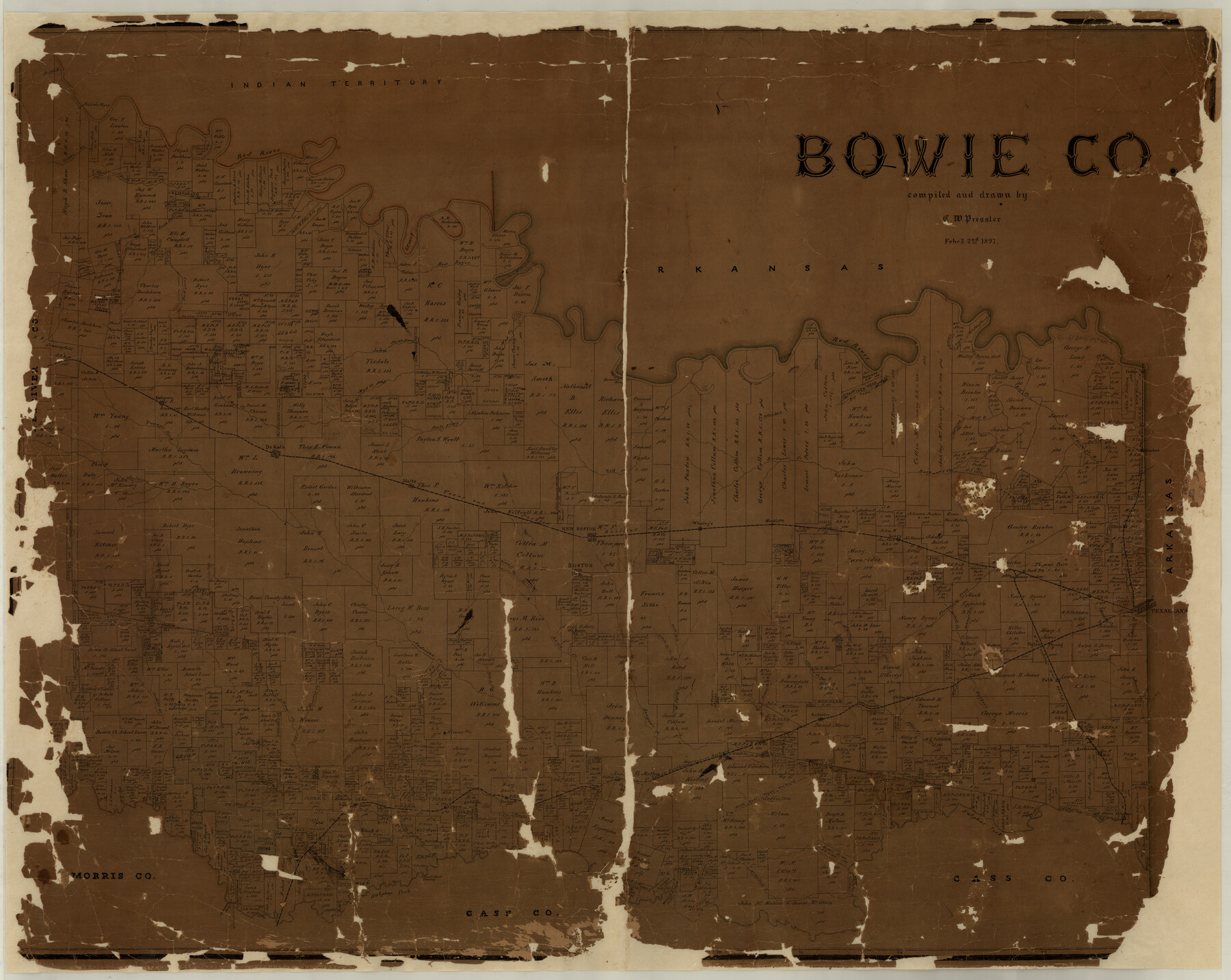
Bowie Co.
-
Map/Doc
7815
-
Collection
General Map Collection
-
Object Dates
1897/2/2 (Creation Date)
-
People and Organizations
Texas General Land Office (Publisher)
Chas. W. Pressler (Compiler)
Chas. W. Pressler (Draftsman)
-
Counties
Bowie
-
Subjects
County
-
Height x Width
35.4 x 44.5 inches
89.9 x 113.0 cm
-
Comments
Conservation funded in 2001 with donation from the Texarkana Chamber of Commerce.
-
Features
Godley Creek
Polk
Harber's Creek
Collins Post Office
Rattle Snake [sic] Hill
Redwater
Massies Creek
Caney Creek
Rocky Creek
Langum's [sic] Creek
Stewart's Creek
Weaver's Creek
Anderson Creek
Hurricane Creek
Rives Creek
Old Boston
Collam's Spring Branch
Ward's Spring Branch
Elliott's Creek
McKinney's Creek
Barr's Creek
Akin's Creek
Fleming
Eylau
Harris Creek
Edd's Creek
McFarland's Branch of Sulphur Fork
McFarland's Lake
Watson's Ferry
Stephenson's Ferry
Malcolm's Bluff Crossing
Sulphur
Sulphur Fork
NETRR
Fairbank
Berry
Basset
Texarkana
Blythes Creek
Ross Creek
Little Piney Creek
Lick Creek
Brooks Creek
Corley
SLS
Maud
Maginnis
Buchannan
Jane's Creek
Mud Creek
Mill Branch of Big Creek
T&FS
Index
Old River
Carter's Lake
Byer's Lake
Wilson's Lake
Ginhouse Lake
Collum's Spring Branch
Brushy Lake
Oakgrove
North Prong of Mud Creek
Big Lake
Spanish Bluffs Indian Territory
East Prong of Mill Creek
Mill Creek Lake
Philips Marsh
Red Bayou
Mill Creek
South Fork of Mill Creek
Little Creek
North Fork of Mill Creek
Ash Slough
Red River
Leary
Ward's Creek
Argo
Park Post Office
Texarcana [sic] Junction
Dawney's Creek
Harber's Creek
Trammel's Trace
Boston
Racoon Creek
Rice's Creek
New Boston
Pecan Bayou
Ohio
Barkman's Creek
Hook's Post Office
Whaley's
Red Creek
T&P
Malta
Anderson Creek
Young's Fork of Anderson Creek
DeKalb
South Prong of Mud Creek
Part of: General Map Collection
Denton County Working Sketch 27

Print $20.00
- Digital $50.00
Denton County Working Sketch 27
1996
Size 41.3 x 35.3 inches
Map/Doc 68632
San Augustine County Working Sketch 1

Print $3.00
- Digital $50.00
San Augustine County Working Sketch 1
1906
Size 9.1 x 11.3 inches
Map/Doc 63688
Reagan County Working Sketch 1

Print $20.00
- Digital $50.00
Reagan County Working Sketch 1
1886
Size 25.0 x 27.3 inches
Map/Doc 71841
Presidio County Rolled Sketch 129

Print $20.00
- Digital $50.00
Presidio County Rolled Sketch 129
1989
Size 27.0 x 46.0 inches
Map/Doc 7399
Hansford County Sketch File 11

Print $6.00
- Digital $50.00
Hansford County Sketch File 11
Size 11.2 x 8.7 inches
Map/Doc 24972
Kenedy County Rolled Sketch 18

Print $20.00
- Digital $50.00
Kenedy County Rolled Sketch 18
1995
Size 29.5 x 39.2 inches
Map/Doc 6472
Stonewall County Sketch File 4

Print $20.00
- Digital $50.00
Stonewall County Sketch File 4
Size 18.2 x 25.7 inches
Map/Doc 12363
Briscoe County Working Sketch 12

Print $40.00
- Digital $50.00
Briscoe County Working Sketch 12
1984
Size 43.6 x 60.3 inches
Map/Doc 67815
Crockett County Working Sketch 96

Print $20.00
- Digital $50.00
Crockett County Working Sketch 96
1979
Size 25.5 x 16.9 inches
Map/Doc 68429
Louisiana and Texas Intracoastal Waterway, Section 7, Galveston Bay to Brazos River and Section 8, Brazos River to Matagorda Bay

Print $20.00
- Digital $50.00
Louisiana and Texas Intracoastal Waterway, Section 7, Galveston Bay to Brazos River and Section 8, Brazos River to Matagorda Bay
1929
Size 30.8 x 43.0 inches
Map/Doc 61842

Dimmit County Sketch File 1

Print $42.00
- Digital $50.00
Dimmit County Sketch File 1
1851
Size 8.8 x 7.5 inches
Map/Doc 21050
You may also like
Young County Working Sketch 27

Print $20.00
- Digital $50.00
Young County Working Sketch 27
1982
Size 24.3 x 32.6 inches
Map/Doc 62050
Dawson County Boundary File 1

Print $48.00
- Digital $50.00
Dawson County Boundary File 1
Size 8.8 x 4.0 inches
Map/Doc 52314
Map of Floyd County

Print $20.00
- Digital $50.00
Map of Floyd County
1888
Size 25.4 x 19.6 inches
Map/Doc 3547
Gaines County Working Sketch 35

Print $20.00
- Digital $50.00
Gaines County Working Sketch 35
1991
Size 36.4 x 42.8 inches
Map/Doc 69335
Milam County Working Sketch 10

Print $20.00
- Digital $50.00
Milam County Working Sketch 10
1986
Size 25.5 x 34.6 inches
Map/Doc 71025
Ochiltree County Rolled Sketch 1

Print $20.00
- Digital $50.00
Ochiltree County Rolled Sketch 1
1942
Size 29.3 x 38.8 inches
Map/Doc 9655
Flight Mission No. DAG-17K, Frame 62, Matagorda County

Print $20.00
- Digital $50.00
Flight Mission No. DAG-17K, Frame 62, Matagorda County
1952
Size 16.4 x 16.4 inches
Map/Doc 86324
Duval County Sketch File 41

Print $20.00
- Digital $50.00
Duval County Sketch File 41
1936
Size 19.6 x 17.2 inches
Map/Doc 11397
[Sketch fragment in Garza and Crosby Counties]
![90855, [Sketch fragment in Garza and Crosby Counties], Twichell Survey Records](https://historictexasmaps.com/wmedia_w700/maps/90855-2.tif.jpg)
Print $20.00
- Digital $50.00
[Sketch fragment in Garza and Crosby Counties]
Size 32.6 x 17.0 inches
Map/Doc 90855
Coleman County Working Sketch 14

Print $20.00
- Digital $50.00
Coleman County Working Sketch 14
1952
Size 27.8 x 21.2 inches
Map/Doc 68080
Map of the City of Corsicana (Navarro County) Texas

Print $40.00
- Digital $50.00
Map of the City of Corsicana (Navarro County) Texas
1963
Size 43.2 x 92.3 inches
Map/Doc 93673
