Starr County Rolled Sketch 32
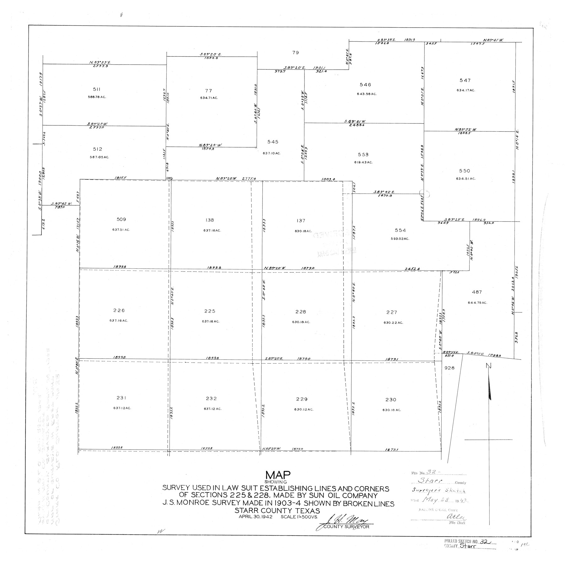
Map showing survey used in lawsuit establishing lines and corners of sections 225 & 228, made by Sun Oil Company, J.S. Monroe survey made in 1903-4 shown by broken lines
-
Map/Doc
7829
-
Collection
General Map Collection
-
Object Dates
1942/4/30 (Creation Date)
1942/5/28 (File Date)
-
People and Organizations
J.H. May (Surveyor/Engineer)
-
Counties
Starr
-
Subjects
Surveying Rolled Sketch
-
Height x Width
23.6 x 23.6 inches
59.9 x 59.9 cm
-
Scale
1" = 500 varas
Part of: General Map Collection
Topographical Map of the Rio Grande, Sheet No. 14

Print $20.00
- Digital $50.00
Topographical Map of the Rio Grande, Sheet No. 14
1912
Map/Doc 89538
Edwards County Sketch File 11

Print $26.00
- Digital $50.00
Edwards County Sketch File 11
1887
Size 13.7 x 8.8 inches
Map/Doc 21687
San Antonio & Aransas Pass RR Co., Fort Bend County, Texas

Print $20.00
- Digital $50.00
San Antonio & Aransas Pass RR Co., Fort Bend County, Texas
1898
Size 10.5 x 31.0 inches
Map/Doc 64143
Map of Clay Co.

Print $40.00
- Digital $50.00
Map of Clay Co.
1896
Size 53.8 x 34.6 inches
Map/Doc 4910
Henderson County

Print $40.00
- Digital $50.00
Henderson County
1922
Size 32.9 x 62.6 inches
Map/Doc 66862
Maps of Gulf Intracoastal Waterway, Texas - Sabine River to the Rio Grande and connecting waterways including ship channels

Print $20.00
- Digital $50.00
Maps of Gulf Intracoastal Waterway, Texas - Sabine River to the Rio Grande and connecting waterways including ship channels
1966
Size 14.6 x 22.2 inches
Map/Doc 61939
Flight Mission No. CLL-1N, Frame 107, Willacy County

Print $20.00
- Digital $50.00
Flight Mission No. CLL-1N, Frame 107, Willacy County
1954
Size 18.5 x 22.1 inches
Map/Doc 87041
Brazos County Working Sketch 3

Print $20.00
- Digital $50.00
Brazos County Working Sketch 3
1976
Size 22.0 x 18.4 inches
Map/Doc 67478
Gillespie County Sketch File 12

Print $4.00
- Digital $50.00
Gillespie County Sketch File 12
1877
Size 9.6 x 6.3 inches
Map/Doc 24151
Burnet County Sketch File 32

Print $4.00
- Digital $50.00
Burnet County Sketch File 32
1894
Size 8.0 x 9.5 inches
Map/Doc 16750
Galveston County Working Sketch 8

Print $20.00
- Digital $50.00
Galveston County Working Sketch 8
1939
Size 43.4 x 39.6 inches
Map/Doc 69345
Nacogdoches County Rolled Sketch 3

Print $20.00
- Digital $50.00
Nacogdoches County Rolled Sketch 3
1985
Size 39.6 x 27.6 inches
Map/Doc 6837
You may also like
Denton County Sketch File 24

Print $40.00
- Digital $50.00
Denton County Sketch File 24
1862
Size 12.2 x 15.1 inches
Map/Doc 20750
Live Oak County Working Sketch 22

Print $40.00
- Digital $50.00
Live Oak County Working Sketch 22
1976
Size 63.1 x 31.9 inches
Map/Doc 70607
[Sketch of Surveys south of League 153]
![90437, [Sketch of Surveys south of League 153], Twichell Survey Records](https://historictexasmaps.com/wmedia_w700/maps/90437-1.tif.jpg)
Print $2.00
- Digital $50.00
[Sketch of Surveys south of League 153]
Size 9.5 x 5.9 inches
Map/Doc 90437
Orange County Aerial Photograph Index Sheet 1

Print $20.00
- Digital $50.00
Orange County Aerial Photograph Index Sheet 1
1957
Size 24.1 x 20.4 inches
Map/Doc 83740
Flight Mission No. DIX-5P, Frame 110, Aransas County

Print $20.00
- Digital $50.00
Flight Mission No. DIX-5P, Frame 110, Aransas County
1956
Size 17.7 x 18.3 inches
Map/Doc 83789
Flight Mission No. BRA-8M, Frame 22, Jefferson County

Print $20.00
- Digital $50.00
Flight Mission No. BRA-8M, Frame 22, Jefferson County
1953
Size 18.5 x 22.4 inches
Map/Doc 85577
Harris County Rolled Sketch 75

Print $20.00
- Digital $50.00
Harris County Rolled Sketch 75
1951
Size 33.8 x 34.9 inches
Map/Doc 76168
Montgomery County Sketch File 28

Print $22.00
- Digital $50.00
Montgomery County Sketch File 28
Size 14.1 x 8.7 inches
Map/Doc 31873
Van Zandt County Sketch File 16 1/2

Print $4.00
- Digital $50.00
Van Zandt County Sketch File 16 1/2
1858
Size 11.0 x 7.8 inches
Map/Doc 39414

The Republic County of San Augustine. December 29, 1845

Print $20.00
The Republic County of San Augustine. December 29, 1845
2020
Size 18.8 x 21.7 inches
Map/Doc 96272
Schleicher County Working Sketch 21

Print $20.00
- Digital $50.00
Schleicher County Working Sketch 21
1953
Size 26.6 x 10.8 inches
Map/Doc 63823