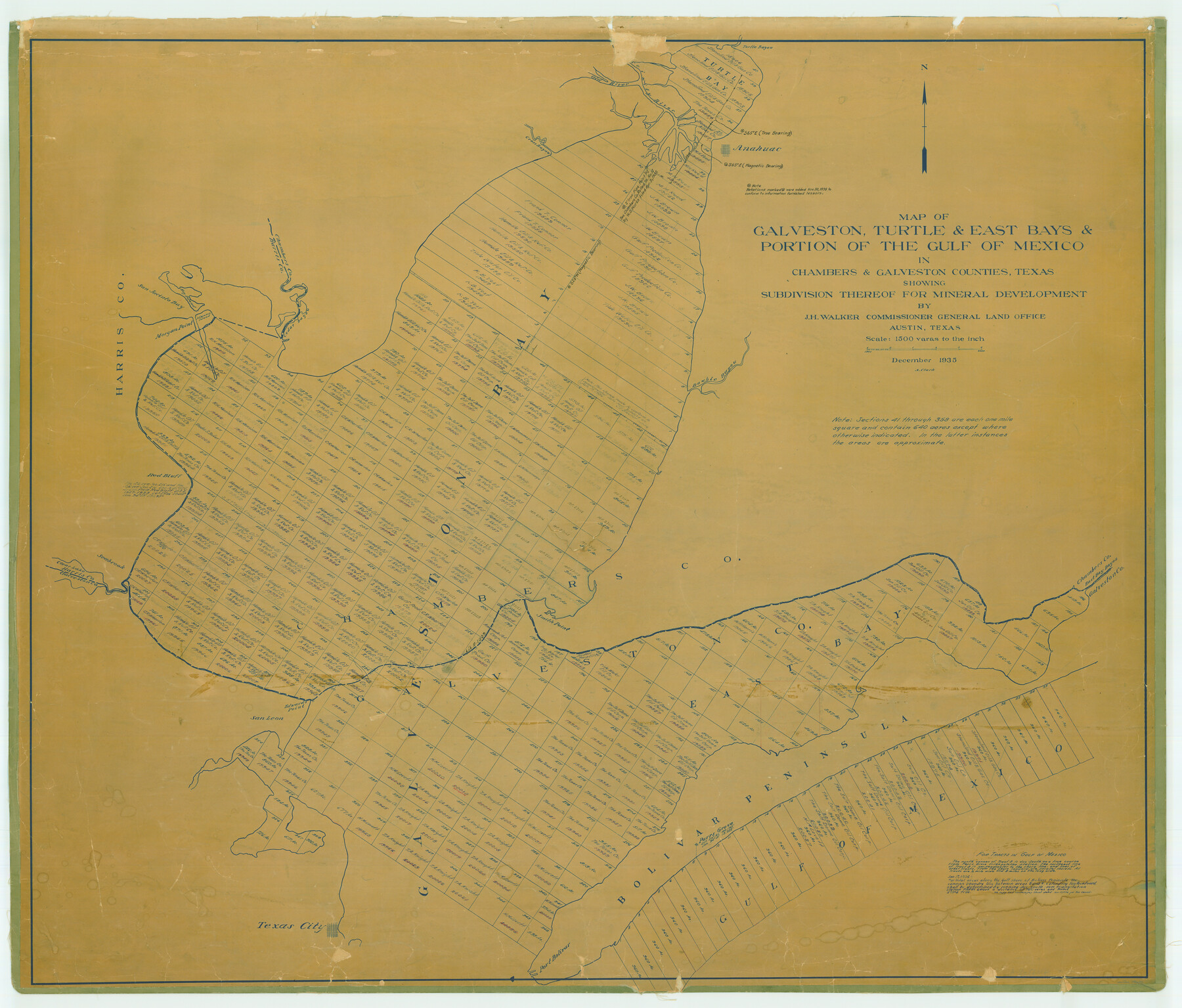
Map of Galveston, Turtle & East Bays & Portion of the Gulf of Mexico in Chambers & Galveston Counties, Texas Showing Subdivision Thereof for Mineral Development
-
Map/Doc
78633
-
Collection
General Map Collection
-
Object Dates
1935 (Creation Date)
-
People and Organizations
J.H. Walker (GLO Commissioner)
-
Counties
Chambers Galveston
-
Height x Width
43.6 x 51.1 inches
110.7 x 129.8 cm
Part of: General Map Collection
Comal County Working Sketch 14

Print $40.00
- Digital $50.00
Comal County Working Sketch 14
1992
Size 25.4 x 49.9 inches
Map/Doc 68180
Hutchinson County Sketch File 5a

Print $6.00
- Digital $50.00
Hutchinson County Sketch File 5a
1900
Size 9.7 x 6.4 inches
Map/Doc 27195
Hudspeth County Sketch File 15

Print $9.00
- Digital $50.00
Hudspeth County Sketch File 15
1927
Size 14.3 x 8.8 inches
Map/Doc 26944
The Texas and Pacific Ry. Co., Station Map, Colorado, Texas

Print $20.00
- Digital $50.00
The Texas and Pacific Ry. Co., Station Map, Colorado, Texas
Size 11.7 x 18.8 inches
Map/Doc 64677
Terrell County Sketch File 38

Print $6.00
- Digital $50.00
Terrell County Sketch File 38
1987
Size 11.3 x 8.8 inches
Map/Doc 38001

Sabine County Sketch File 10

Print $4.00
Sabine County Sketch File 10
1873
Size 8.3 x 10.2 inches
Map/Doc 35627
Sutton County Boundary File 6

Print $10.00
- Digital $50.00
Sutton County Boundary File 6
Size 14.4 x 8.8 inches
Map/Doc 59070
Duval County Sketch File 20 1/2

Print $4.00
- Digital $50.00
Duval County Sketch File 20 1/2
1880
Size 10.3 x 8.4 inches
Map/Doc 21324
Cooke County Working Sketch 34

Print $20.00
- Digital $50.00
Cooke County Working Sketch 34
1984
Size 41.7 x 38.0 inches
Map/Doc 68271
Travis County Working Sketch 31

Print $20.00
- Digital $50.00
Travis County Working Sketch 31
1965
Size 31.2 x 35.6 inches
Map/Doc 69415
Hamilton County Sketch File 23

Print $20.00
- Digital $50.00
Hamilton County Sketch File 23
1955
Size 25.8 x 24.8 inches
Map/Doc 11618
You may also like
Map of survey of a part of Padre and Mustang Islands made for the Office of the Attorney General of the State of Texas

Print $20.00
- Digital $50.00
Map of survey of a part of Padre and Mustang Islands made for the Office of the Attorney General of the State of Texas
1941
Size 40.8 x 39.5 inches
Map/Doc 2257
Fort Bend County Sketch File 1

Print $6.00
- Digital $50.00
Fort Bend County Sketch File 1
Size 14.7 x 9.5 inches
Map/Doc 22876
Map of Orange County

Print $20.00
- Digital $50.00
Map of Orange County
1862
Size 13.6 x 16.5 inches
Map/Doc 3929
Polk County Working Sketch 13

Print $20.00
- Digital $50.00
Polk County Working Sketch 13
1942
Size 17.1 x 20.6 inches
Map/Doc 71628
San Augustine County Sketch File 11

Print $4.00
San Augustine County Sketch File 11
Size 12.1 x 7.7 inches
Map/Doc 35654
Coast Chart No. 210 Aransas Pass and Corpus Christi Bay with the coast to latitude 27° 12' Texas

Print $20.00
- Digital $50.00
Coast Chart No. 210 Aransas Pass and Corpus Christi Bay with the coast to latitude 27° 12' Texas
1887
Size 27.9 x 18.2 inches
Map/Doc 72791
University Land Block 46, Culberson County, Texas

Print $20.00
- Digital $50.00
University Land Block 46, Culberson County, Texas
1938
Size 35.1 x 22.0 inches
Map/Doc 2410

Harbor Pass and Bar at Brazos Santiago, Texas

Print $20.00
- Digital $50.00
Harbor Pass and Bar at Brazos Santiago, Texas
1871
Size 18.3 x 27.4 inches
Map/Doc 73036
Location of the Southern Kansas Railway of Texas

Print $40.00
- Digital $50.00
Location of the Southern Kansas Railway of Texas
1887
Size 19.0 x 103.2 inches
Map/Doc 64182
Flight Mission No. DQN-7K, Frame 90, Calhoun County

Print $20.00
- Digital $50.00
Flight Mission No. DQN-7K, Frame 90, Calhoun County
1953
Size 18.6 x 22.2 inches
Map/Doc 84481
[Stone, Kyle and Kyle Block M6]
![90392, [Stone, Kyle and Kyle Block M6], Twichell Survey Records](https://historictexasmaps.com/wmedia_w700/maps/90392-1.tif.jpg)
Print $3.00
- Digital $50.00
[Stone, Kyle and Kyle Block M6]
Size 11.9 x 15.2 inches
Map/Doc 90392