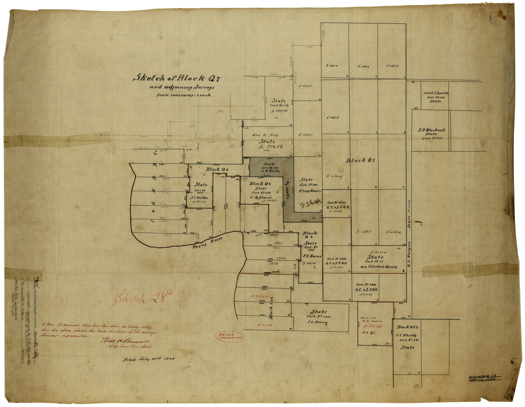
Val Verde County Rolled Sketch 28
Sketch of Block Q7 and adjoining surveys
-
Map/Doc
8110
-
Collection
General Map Collection
-
Object Dates
7/22/1884 (File Date)
-
People and Organizations
Will H. Bonnell (Surveyor/Engineer)
-
Counties
Val Verde
-
Subjects
Surveying Rolled Sketch
-
Height x Width
28.5 x 36.1 inches
72.4 x 91.7 cm
-
Medium
linen, manuscript
-
Scale
1" = 1000 varas
Part of: General Map Collection
Brazoria County Working Sketch 38

Print $40.00
- Digital $50.00
Brazoria County Working Sketch 38
1981
Size 53.2 x 37.7 inches
Map/Doc 67523
Edwards County Sketch File 1

Print $10.00
- Digital $50.00
Edwards County Sketch File 1
Size 9.2 x 7.0 inches
Map/Doc 21672
Travis County Rolled Sketch 25A

Print $20.00
- Digital $50.00
Travis County Rolled Sketch 25A
1942
Size 21.7 x 29.1 inches
Map/Doc 8027
Glasscock County Sketch File 8

Print $6.00
- Digital $50.00
Glasscock County Sketch File 8
Size 9.5 x 14.9 inches
Map/Doc 24168
Nacogdoches County Working Sketch 1

Print $20.00
- Digital $50.00
Nacogdoches County Working Sketch 1
Size 27.8 x 35.8 inches
Map/Doc 71217
Grimes County Working Sketch 5

Print $40.00
- Digital $50.00
Grimes County Working Sketch 5
1949
Size 43.6 x 83.2 inches
Map/Doc 63296
Crosby County Sketch File 25

Print $12.00
- Digital $50.00
Crosby County Sketch File 25
1912
Size 11.2 x 8.7 inches
Map/Doc 20093
Loving County Rolled Sketch 15

Print $20.00
- Digital $50.00
Loving County Rolled Sketch 15
2015
Size 36.2 x 24.4 inches
Map/Doc 93793
Harrison County Working Sketch 7

Print $20.00
- Digital $50.00
Harrison County Working Sketch 7
1955
Size 32.0 x 39.0 inches
Map/Doc 66027
Kimble County Working Sketch 45

Print $20.00
- Digital $50.00
Kimble County Working Sketch 45
1950
Size 26.4 x 28.5 inches
Map/Doc 70113
El Paso County Working Sketch Graphic Index - north part

Print $20.00
- Digital $50.00
El Paso County Working Sketch Graphic Index - north part
1977
Size 33.4 x 45.0 inches
Map/Doc 76536
Marion County Working Sketch 24

Print $20.00
- Digital $50.00
Marion County Working Sketch 24
1960
Size 21.4 x 26.4 inches
Map/Doc 70800
You may also like
[De Loches County School Land]
![91198, [De Loches County School Land], Twichell Survey Records](https://historictexasmaps.com/wmedia_w700/maps/91198-1.tif.jpg)
Print $20.00
- Digital $50.00
[De Loches County School Land]
Size 20.4 x 35.2 inches
Map/Doc 91198
Angelina County Sketch File 15f

Print $4.00
- Digital $50.00
Angelina County Sketch File 15f
Size 10.4 x 7.6 inches
Map/Doc 12994
Liberty County Sketch File 20

Print $6.00
- Digital $50.00
Liberty County Sketch File 20
Size 7.8 x 9.9 inches
Map/Doc 29925
Map of Harris County, Texas

Print $20.00
Map of Harris County, Texas
1879
Size 24.8 x 36.0 inches
Map/Doc 88948
Edwards County Working Sketch 109

Print $40.00
- Digital $50.00
Edwards County Working Sketch 109
1972
Size 51.8 x 37.6 inches
Map/Doc 68985
Cameron County Rolled Sketch Z

Print $20.00
- Digital $50.00
Cameron County Rolled Sketch Z
1936
Size 24.6 x 31.3 inches
Map/Doc 5400
Ward County Working Sketch 55

Print $20.00
- Digital $50.00
Ward County Working Sketch 55
1986
Size 30.0 x 36.8 inches
Map/Doc 72361
Pecos County Sketch File 116

Print $6.00
- Digital $50.00
Pecos County Sketch File 116
1913
Size 10.9 x 8.8 inches
Map/Doc 34092
San Saba County Working Sketch 2

Print $20.00
- Digital $50.00
San Saba County Working Sketch 2
1928
Size 23.2 x 27.2 inches
Map/Doc 63790
[Blocks L. E. and B8]
![90666, [Blocks L. E. and B8], Twichell Survey Records](https://historictexasmaps.com/wmedia_w700/maps/90666-2.tif.jpg)
Print $20.00
- Digital $50.00
[Blocks L. E. and B8]
Size 18.4 x 13.6 inches
Map/Doc 90666
Flight Mission No. DIX-6P, Frame 187, Aransas County

Print $20.00
- Digital $50.00
Flight Mission No. DIX-6P, Frame 187, Aransas County
1956
Size 19.1 x 22.7 inches
Map/Doc 83849
McMullen County Sketch File 42

Print $6.00
- Digital $50.00
McMullen County Sketch File 42
1941
Size 14.2 x 8.9 inches
Map/Doc 31418