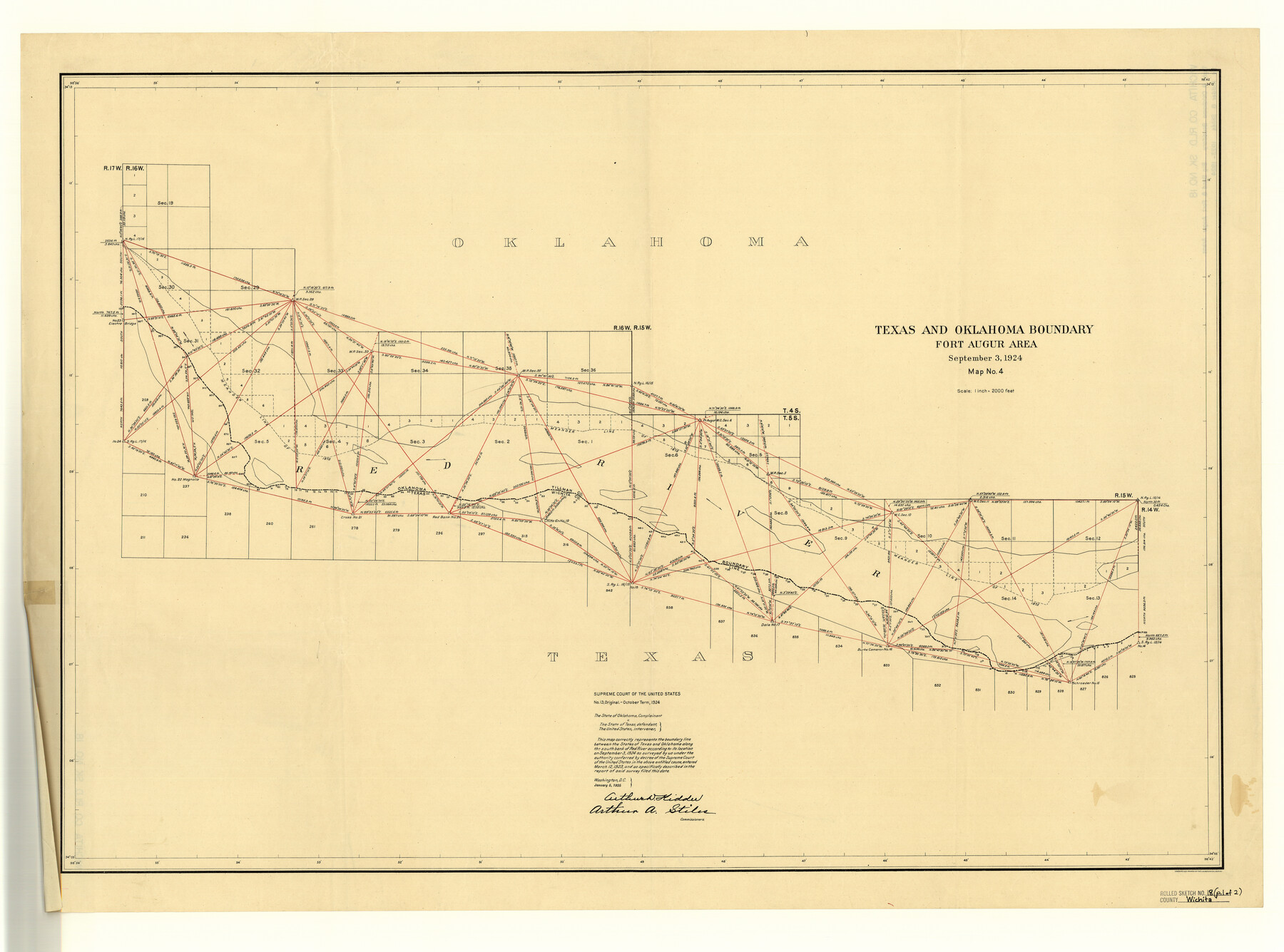
Wichita County Rolled Sketch 18
Texas and Oklahoma Boundary - Fort Augur area
-
Map/Doc
8253
-
Collection
General Map Collection
-
Object Dates
1924/9/3 (Creation Date)
1958/4/31 (File Date)
-
People and Organizations
Arthur D. Kidder (Commissioner)
Arthur A. Stiles (Commissioner)
-
Counties
Wichita
-
Subjects
Surveying Rolled Sketch Texas Boundaries
-
Height x Width
30.0 x 40.5 inches
76.2 x 102.9 cm
-
Medium
paper, etching/engraving/lithograph
-
Scale
1" = 2000 feet
-
Comments
Map from Supreme Court of the United States No. 13, Original - October Term, 1924 - the State of Oklahoma, complainant vs. the State of Texas, defendant and the United States, intervener
Part of: General Map Collection
Refugio County Rolled Sketch 3

Print $20.00
- Digital $50.00
Refugio County Rolled Sketch 3
1935
Size 33.9 x 32.6 inches
Map/Doc 9857
Portion of States Submerged Area in Matagorda Bay

Print $20.00
- Digital $50.00
Portion of States Submerged Area in Matagorda Bay
1923
Size 12.7 x 13.5 inches
Map/Doc 2956
Crockett County Sketch File 88

Print $3.00
- Digital $50.00
Crockett County Sketch File 88
1958
Size 19.3 x 15.8 inches
Map/Doc 11237
Hemphill County Working Sketch 21

Print $40.00
- Digital $50.00
Hemphill County Working Sketch 21
1973
Size 79.0 x 32.6 inches
Map/Doc 66116
Webb County Working Sketch 67

Print $40.00
- Digital $50.00
Webb County Working Sketch 67
1966
Size 60.9 x 43.7 inches
Map/Doc 72434
Val Verde County Working Sketch 45

Print $20.00
- Digital $50.00
Val Verde County Working Sketch 45
1945
Size 29.2 x 25.2 inches
Map/Doc 72180
Flight Mission No. BRA-9M, Frame 81, Jefferson County

Print $20.00
- Digital $50.00
Flight Mission No. BRA-9M, Frame 81, Jefferson County
1953
Size 18.3 x 22.6 inches
Map/Doc 85664
United States Gulf Coast - from Galveston to the Rio Grande

Print $20.00
- Digital $50.00
United States Gulf Coast - from Galveston to the Rio Grande
1915
Size 26.4 x 18.2 inches
Map/Doc 72733
Flight Mission No. CGI-3N, Frame 75, Cameron County

Print $20.00
- Digital $50.00
Flight Mission No. CGI-3N, Frame 75, Cameron County
1954
Size 18.6 x 22.2 inches
Map/Doc 84569
Chambers County NRC Article 33.136 Sketch 16

Print $184.00
Chambers County NRC Article 33.136 Sketch 16
2025
Map/Doc 97514
Cooke County Boundary File 1b

Print $28.00
- Digital $50.00
Cooke County Boundary File 1b
Size 12.6 x 7.4 inches
Map/Doc 51835
Flight Mission No. CLL-3N, Frame 35, Willacy County

Print $20.00
- Digital $50.00
Flight Mission No. CLL-3N, Frame 35, Willacy County
1954
Size 18.3 x 22.1 inches
Map/Doc 87093
You may also like
Origin of Exports and Destination of Imports at Galveston during 1921

Print $20.00
- Digital $50.00
Origin of Exports and Destination of Imports at Galveston during 1921
1921
Size 13.7 x 19.9 inches
Map/Doc 97168
Webb County Rolled Sketch 69

Print $20.00
- Digital $50.00
Webb County Rolled Sketch 69
1964
Size 13.9 x 22.3 inches
Map/Doc 8216
Cameron County Rolled Sketch 32

Print $40.00
- Digital $50.00
Cameron County Rolled Sketch 32
1981
Size 136.6 x 18.1 inches
Map/Doc 8579

Armstrong County Rolled Sketch 4

Print $40.00
- Digital $50.00
Armstrong County Rolled Sketch 4
1876
Size 37.8 x 70.8 inches
Map/Doc 8426
[Blk. B, part of Blk. M, and north line of Morris County School Land]
![90359, [Blk. B, part of Blk. M, and north line of Morris County School Land], Twichell Survey Records](https://historictexasmaps.com/wmedia_w700/maps/90359-1.tif.jpg)
Print $20.00
- Digital $50.00
[Blk. B, part of Blk. M, and north line of Morris County School Land]
Size 23.9 x 22.7 inches
Map/Doc 90359
Jones & Murphy's Map of the City of Dallas, Texas compiled from the records of Dallas Co., and latest surveys of the City Engineer

Print $20.00
- Digital $50.00
Jones & Murphy's Map of the City of Dallas, Texas compiled from the records of Dallas Co., and latest surveys of the City Engineer
1878
Size 22.0 x 29.9 inches
Map/Doc 97262
Williamson County Boundary File 4

Print $40.00
- Digital $50.00
Williamson County Boundary File 4
Size 8.3 x 13.3 inches
Map/Doc 60013
Flight Mission No. DQN-6K, Frame 89, Calhoun County

Print $20.00
- Digital $50.00
Flight Mission No. DQN-6K, Frame 89, Calhoun County
1953
Size 18.5 x 22.2 inches
Map/Doc 84449
[Large surveys along the Navasota River]
![48, [Large surveys along the Navasota River], General Map Collection](https://historictexasmaps.com/wmedia_w700/maps/48.tif.jpg)
Print $20.00
- Digital $50.00
[Large surveys along the Navasota River]
1840
Size 24.5 x 14.3 inches
Map/Doc 48
Brewster County Boundary File 1b

Print $32.00
- Digital $50.00
Brewster County Boundary File 1b
Size 9.2 x 11.3 inches
Map/Doc 50740
Jefferson County Working Sketch 1

Print $20.00
- Digital $50.00
Jefferson County Working Sketch 1
Size 22.7 x 17.5 inches
Map/Doc 66544