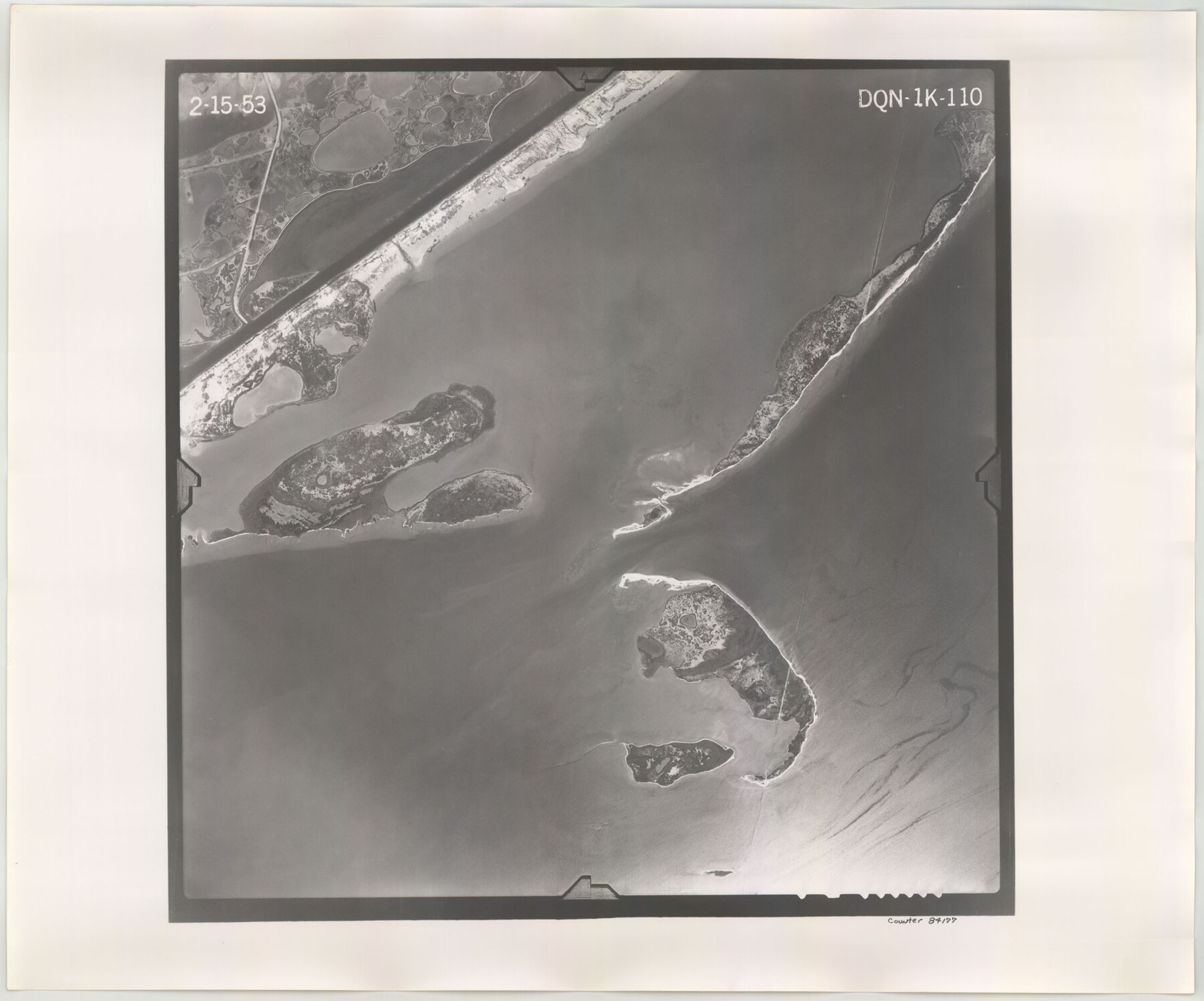
Flight Mission No. DQN-1K, Frame 110, Calhoun County
DQN-1K-110
-
Map/Doc
84177
-
Collection
General Map Collection
-
Object Dates
1953/2/15 (Creation Date)
-
People and Organizations
U. S. Department of Agriculture (Publisher)
-
Counties
Calhoun
-
Subjects
Aerial Photograph
-
Height x Width
18.4 x 22.2 inches
46.7 x 56.4 cm
-
Comments
Flown by Aero Exploration Company of Tulsa, Oklahoma.
Part of: General Map Collection
Flight Mission No. BRA-16M, Frame 107, Jefferson County

Print $20.00
- Digital $50.00
Flight Mission No. BRA-16M, Frame 107, Jefferson County
1953
Size 18.5 x 22.3 inches
Map/Doc 85719
Hutchinson Co.

Print $20.00
- Digital $50.00
Hutchinson Co.
1891
Size 27.5 x 21.3 inches
Map/Doc 4986
Map showing the environs of Brazos Islnd., Texas

Print $20.00
- Digital $50.00
Map showing the environs of Brazos Islnd., Texas
1864
Size 27.1 x 18.2 inches
Map/Doc 72990
[Map of the Hearne and Brazos Valley Railroad from Mumford to Moseley's Ferry]
![64401, [Map of the Hearne and Brazos Valley Railroad from Mumford to Moseley's Ferry], General Map Collection](https://historictexasmaps.com/wmedia_w700/maps/64401.tif.jpg)
Print $40.00
- Digital $50.00
[Map of the Hearne and Brazos Valley Railroad from Mumford to Moseley's Ferry]
1892
Size 20.0 x 71.5 inches
Map/Doc 64401
Edwards County Rolled Sketch 22

Print $20.00
- Digital $50.00
Edwards County Rolled Sketch 22
1951
Size 46.0 x 25.4 inches
Map/Doc 8845
Phelps & Watson's historical and military map of the border & southern states

Print $20.00
- Digital $50.00
Phelps & Watson's historical and military map of the border & southern states
1863
Size 26.1 x 37.1 inches
Map/Doc 97083
Flight Mission No. BQR-9K, Frame 50, Brazoria County

Print $20.00
- Digital $50.00
Flight Mission No. BQR-9K, Frame 50, Brazoria County
1952
Size 18.7 x 22.4 inches
Map/Doc 84054
Map of Milam County

Print $20.00
- Digital $50.00
Map of Milam County
1868
Size 28.2 x 23.9 inches
Map/Doc 3882
Upton County Rolled Sketch 29

Print $20.00
- Digital $50.00
Upton County Rolled Sketch 29
1947
Size 32.0 x 45.3 inches
Map/Doc 10736
Pecos County Sketch File 29c

Print $14.00
- Digital $50.00
Pecos County Sketch File 29c
1929
Size 11.2 x 8.8 inches
Map/Doc 33698
Flight Mission No. CUG-2P, Frame 11, Kleberg County

Print $20.00
- Digital $50.00
Flight Mission No. CUG-2P, Frame 11, Kleberg County
1956
Size 18.5 x 22.2 inches
Map/Doc 86183
Lipscomb County Sketch File 1

Print $40.00
- Digital $50.00
Lipscomb County Sketch File 1
Size 51.7 x 14.2 inches
Map/Doc 10525
You may also like
Hidalgo County Sketch File 8

Print $4.00
- Digital $50.00
Hidalgo County Sketch File 8
1890
Size 14.1 x 8.6 inches
Map/Doc 26407
Sterling County Working Sketch 1

Print $20.00
- Digital $50.00
Sterling County Working Sketch 1
1926
Size 30.3 x 29.6 inches
Map/Doc 63983
Webb County Sketch File 4

Print $22.00
- Digital $50.00
Webb County Sketch File 4
1855
Size 8.4 x 14.2 inches
Map/Doc 39716
Briscoe County Sketch File 8

Print $6.00
- Digital $50.00
Briscoe County Sketch File 8
1896
Size 10.5 x 8.3 inches
Map/Doc 16417
Polk County Sketch File 26a

Print $10.00
- Digital $50.00
Polk County Sketch File 26a
1878
Size 14.2 x 8.7 inches
Map/Doc 34189
Cameron County Rolled Sketch 25

Print $40.00
- Digital $50.00
Cameron County Rolled Sketch 25
1977
Size 25.0 x 72.9 inches
Map/Doc 5791
[Surveying Test and Answer Key]
![76001, [Surveying Test and Answer Key], General Map Collection](https://historictexasmaps.com/wmedia_w700/maps/76001.tif.jpg)
Print $20.00
- Digital $50.00
[Surveying Test and Answer Key]
Size 17.5 x 19.9 inches
Map/Doc 76001
Montgomery County Working Sketch 72

Print $20.00
- Digital $50.00
Montgomery County Working Sketch 72
1979
Size 17.2 x 32.4 inches
Map/Doc 71179
Zavala County Sketch File 35

Print $4.00
- Digital $50.00
Zavala County Sketch File 35
1887
Size 11.3 x 9.0 inches
Map/Doc 41397
Plat Section 2, Block B-16

Print $20.00
- Digital $50.00
Plat Section 2, Block B-16
1930
Size 19.0 x 9.8 inches
Map/Doc 90802
Terry County Boundary File 4a

Print $70.00
- Digital $50.00
Terry County Boundary File 4a
Size 11.4 x 8.8 inches
Map/Doc 59249
Wise County Sketch File 52

Print $20.00
- Digital $50.00
Wise County Sketch File 52
1982
Size 14.2 x 8.6 inches
Map/Doc 40619