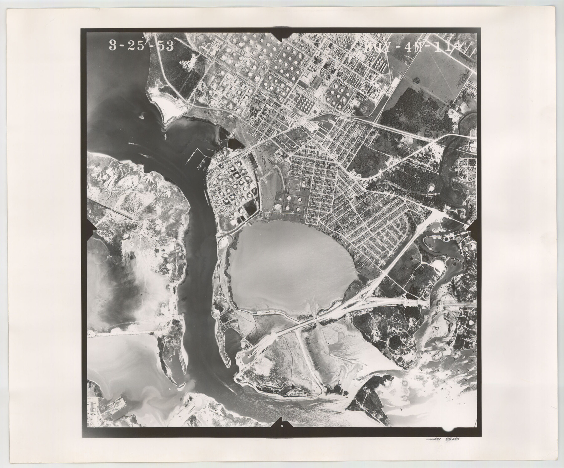
Flight Mission No. BQY-4M, Frame 114, Harris County
BQY-4M-114
-
Map/Doc
85281
-
Collection
General Map Collection
-
Object Dates
1953/3/25 (Creation Date)
-
People and Organizations
U. S. Department of Agriculture (Publisher)
-
Counties
Harris
-
Subjects
Aerial Photograph
-
Height x Width
18.7 x 22.5 inches
47.5 x 57.2 cm
-
Comments
Flown by Jack Ammann Photogrammetric Engineers of San Antonio, Texas.
Part of: General Map Collection
Polk County Boundary File 2a

Print $40.00
- Digital $50.00
Polk County Boundary File 2a
Size 31.6 x 9.6 inches
Map/Doc 57928
Irion County Boundary File 1

Print $36.00
- Digital $50.00
Irion County Boundary File 1
Size 8.9 x 4.1 inches
Map/Doc 55316
Castro County Working Sketch Graphic Index

Print $20.00
- Digital $50.00
Castro County Working Sketch Graphic Index
1932
Size 43.1 x 38.2 inches
Map/Doc 76490
Maverick County Sketch File 13a

Print $6.00
- Digital $50.00
Maverick County Sketch File 13a
1883
Size 14.1 x 8.8 inches
Map/Doc 31108
Limestone County Sketch File 21

Print $40.00
- Digital $50.00
Limestone County Sketch File 21
1922
Size 17.0 x 12.3 inches
Map/Doc 30199

Dimmit County Sketch File 58

Print $20.00
- Digital $50.00
Dimmit County Sketch File 58
1951
Size 18.0 x 9.8 inches
Map/Doc 11361
A Topographical Map of the Government Tract Adjoining the City of Austin

Print $20.00
- Digital $50.00
A Topographical Map of the Government Tract Adjoining the City of Austin
1840
Size 44.1 x 38.4 inches
Map/Doc 2178
Live Oak County Rolled Sketch 2

Print $20.00
- Digital $50.00
Live Oak County Rolled Sketch 2
1944
Size 34.1 x 26.6 inches
Map/Doc 6632
West Part Presidio Co.

Print $20.00
- Digital $50.00
West Part Presidio Co.
1974
Size 42.1 x 33.3 inches
Map/Doc 73267
Dallam County Sketch File 9

Print $40.00
- Digital $50.00
Dallam County Sketch File 9
1914
Size 9.0 x 7.7 inches
Map/Doc 20357
Hays County Working Sketch 20

Print $40.00
- Digital $50.00
Hays County Working Sketch 20
1980
Size 42.9 x 65.6 inches
Map/Doc 66094
You may also like
Val Verde County Working Sketch 53

Print $20.00
- Digital $50.00
Val Verde County Working Sketch 53
1956
Size 42.8 x 47.7 inches
Map/Doc 72188
The Land Offices. No. 6, Washington, December 22, 1836

Print $20.00
The Land Offices. No. 6, Washington, December 22, 1836
2020
Size 16.5 x 21.7 inches
Map/Doc 96419
A New Map of Texas, Oregon, and California with the regions adjoining compiled from the most recent authorities

Print $20.00
- Digital $50.00
A New Map of Texas, Oregon, and California with the regions adjoining compiled from the most recent authorities
1846
Size 23.0 x 21.2 inches
Map/Doc 95748
Sketch from Ward and Crane Counties

Print $20.00
- Digital $50.00
Sketch from Ward and Crane Counties
Size 42.9 x 23.6 inches
Map/Doc 92557
Pecos County Sketch File 14A

Print $20.00
- Digital $50.00
Pecos County Sketch File 14A
Size 33.7 x 23.0 inches
Map/Doc 12158
Flight Mission No. DCL-7C, Frame 3, Kenedy County

Print $20.00
- Digital $50.00
Flight Mission No. DCL-7C, Frame 3, Kenedy County
1943
Size 18.5 x 22.3 inches
Map/Doc 85995
[Block C-35 Public School Land]
![93227, [Block C-35 Public School Land], Twichell Survey Records](https://historictexasmaps.com/wmedia_w700/maps/93227-1.tif.jpg)
Print $20.00
- Digital $50.00
[Block C-35 Public School Land]
1943
Size 14.9 x 17.0 inches
Map/Doc 93227
Goliad County Rolled Sketch 1

Print $20.00
- Digital $50.00
Goliad County Rolled Sketch 1
1941
Size 31.4 x 38.5 inches
Map/Doc 6023
Pecos County Sketch File 68

Print $6.00
- Digital $50.00
Pecos County Sketch File 68
1920
Size 14.4 x 8.8 inches
Map/Doc 33866
Map of The Surveyed Part of Peters Colony Texas

Print $40.00
- Digital $50.00
Map of The Surveyed Part of Peters Colony Texas
1858
Size 45.0 x 58.1 inches
Map/Doc 4653
Knox County Working Sketch 7

Print $3.00
- Digital $50.00
Knox County Working Sketch 7
1941
Size 11.1 x 9.1 inches
Map/Doc 70249
Gregg County Rolled Sketch 18A

Print $313.00
- Digital $50.00
Gregg County Rolled Sketch 18A
1934
Size 10.5 x 15.5 inches
Map/Doc 45469