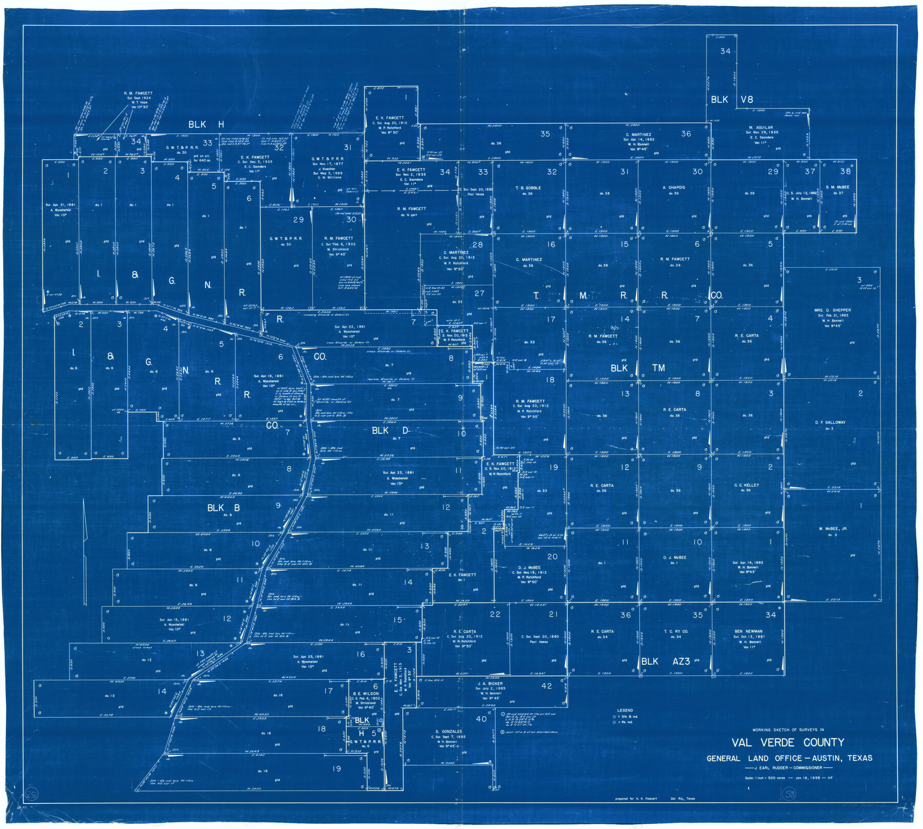
Val Verde County Working Sketch 53
-
Map/Doc
72188
-
Collection
General Map Collection
-
Object Dates
1/16/1956 (Creation Date)
-
People and Organizations
Herman Forbes (Draftsman)
-
Counties
Val Verde
-
Subjects
Surveying Working Sketch
-
Height x Width
42.8 x 47.7 inches
108.7 x 121.2 cm
-
Scale
1" = 500 varas
Part of: General Map Collection
Texas Intracoastal Waterway - Stover Point to Port Brownsville including Brazos Santiago

Print $20.00
- Digital $50.00
Texas Intracoastal Waterway - Stover Point to Port Brownsville including Brazos Santiago
1961
Size 27.2 x 38.9 inches
Map/Doc 73519
Medina County Sketch File 10

Print $20.00
- Digital $50.00
Medina County Sketch File 10
Size 18.0 x 22.6 inches
Map/Doc 12068
San Patricio County Sketch File 18

Print $4.00
San Patricio County Sketch File 18
Size 6.2 x 8.3 inches
Map/Doc 36066
Medina County Working Sketch 26

Print $20.00
- Digital $50.00
Medina County Working Sketch 26
1985
Size 30.6 x 30.5 inches
Map/Doc 70941
Fannin County Working Sketch 2

Print $3.00
- Digital $50.00
Fannin County Working Sketch 2
1911
Size 14.9 x 10.3 inches
Map/Doc 69156
Map of Brazoria County

Print $20.00
- Digital $50.00
Map of Brazoria County
1918
Size 26.1 x 22.6 inches
Map/Doc 1518
Lampasas County Boundary File 11

Print $4.00
- Digital $50.00
Lampasas County Boundary File 11
Size 14.0 x 8.6 inches
Map/Doc 56189
Zavala County Sketch File 41

Print $20.00
- Digital $50.00
Zavala County Sketch File 41
1900
Size 24.0 x 21.6 inches
Map/Doc 12731
Hopkins County Working Sketch Graphic Index

Print $20.00
- Digital $50.00
Hopkins County Working Sketch Graphic Index
1942
Size 40.6 x 38.7 inches
Map/Doc 76581
Kimble County Sketch File 28

Print $20.00
- Digital $50.00
Kimble County Sketch File 28
Size 23.3 x 17.8 inches
Map/Doc 11927
Red River County Working Sketch 46

Print $20.00
- Digital $50.00
Red River County Working Sketch 46
Size 34.3 x 38.9 inches
Map/Doc 72029
Culberson County Sketch File 4a

Print $10.00
- Digital $50.00
Culberson County Sketch File 4a
Size 9.2 x 7.9 inches
Map/Doc 20131
You may also like

Galveston County Rolled Sketch 18

Print $20.00
- Digital $50.00
Galveston County Rolled Sketch 18
1959
Size 27.9 x 35.8 inches
Map/Doc 5955
Real County Working Sketch 3

Print $20.00
- Digital $50.00
Real County Working Sketch 3
Size 35.0 x 24.9 inches
Map/Doc 71895
Wilbarger County Working Sketch 17

Print $20.00
- Digital $50.00
Wilbarger County Working Sketch 17
1957
Size 7.5 x 18.4 inches
Map/Doc 72555
Reeves County Rolled Sketch 26

Print $20.00
- Digital $50.00
Reeves County Rolled Sketch 26
1985
Size 21.6 x 27.7 inches
Map/Doc 7495
Flight Mission No. DQN-1K, Frame 114, Calhoun County

Print $20.00
- Digital $50.00
Flight Mission No. DQN-1K, Frame 114, Calhoun County
1953
Size 18.5 x 22.3 inches
Map/Doc 84180
Galveston County Sketch File 42

Print $20.00
- Digital $50.00
Galveston County Sketch File 42
1899
Size 23.9 x 23.7 inches
Map/Doc 11538
Haskell County Working Sketch 6

Print $20.00
- Digital $50.00
Haskell County Working Sketch 6
1949
Size 18.9 x 16.4 inches
Map/Doc 66064
Brewster County Sketch File N-3b

Print $4.00
- Digital $50.00
Brewster County Sketch File N-3b
Size 12.7 x 8.4 inches
Map/Doc 15592

Cherokee County Rolled Sketch 2

Print $20.00
- Digital $50.00
Cherokee County Rolled Sketch 2
1954
Size 44.6 x 36.0 inches
Map/Doc 8596
Map of Taylor County

Print $20.00
- Digital $50.00
Map of Taylor County
1858
Size 24.0 x 25.3 inches
Map/Doc 4070