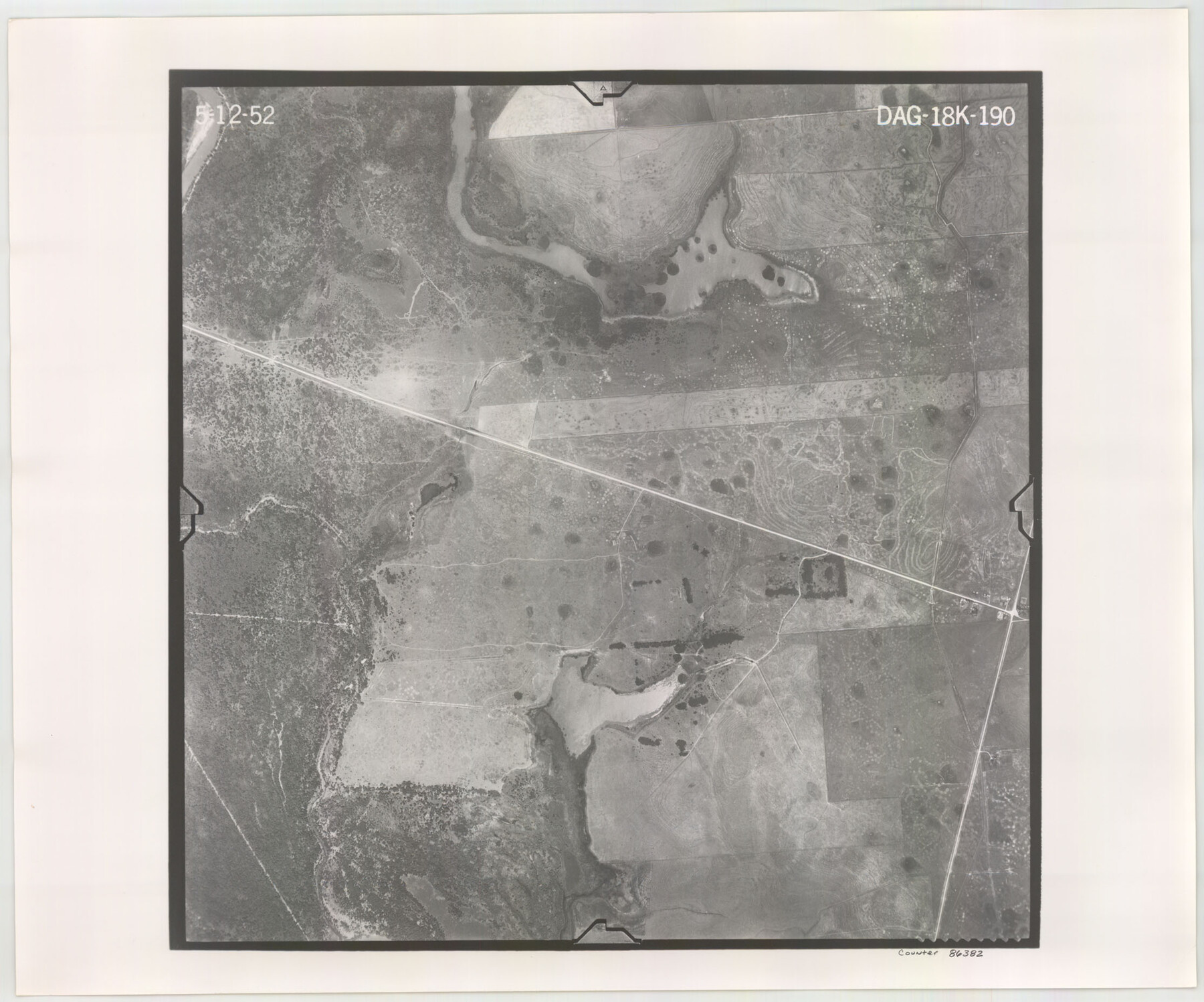
Flight Mission No. DAG-18K, Frame 190, Matagorda County
DAG-18K-190
-
Map/Doc
86382
-
Collection
General Map Collection
-
Object Dates
1952/5/12 (Creation Date)
-
People and Organizations
U. S. Department of Agriculture (Publisher)
-
Counties
Matagorda
-
Subjects
Aerial Photograph
-
Height x Width
18.6 x 22.3 inches
47.2 x 56.6 cm
-
Comments
Flown by Aero Exploration Company of Tulsa, Oklahoma.
Part of: General Map Collection
Atascosa County Sketch File 37

Print $40.00
- Digital $50.00
Atascosa County Sketch File 37
Size 17.6 x 12.9 inches
Map/Doc 13829
San Jacinto County Working Sketch 21

Print $20.00
- Digital $50.00
San Jacinto County Working Sketch 21
1939
Size 32.1 x 25.5 inches
Map/Doc 63734
Zapata County Rolled Sketch 15

Print $20.00
- Digital $50.00
Zapata County Rolled Sketch 15
1925
Size 14.6 x 16.4 inches
Map/Doc 8313
Carte du Chemin de Fer de Galveston, Houston et Henderson

Print $20.00
- Digital $50.00
Carte du Chemin de Fer de Galveston, Houston et Henderson
1857
Size 35.4 x 27.2 inches
Map/Doc 89274
Navigation Maps of Gulf Intracoastal Waterway, Port Arthur to Brownsville, Texas

Print $4.00
- Digital $50.00
Navigation Maps of Gulf Intracoastal Waterway, Port Arthur to Brownsville, Texas
1951
Size 16.6 x 21.2 inches
Map/Doc 65445
[Surveys in the Bexar District along the Medina River]
![128, [Surveys in the Bexar District along the Medina River], General Map Collection](https://historictexasmaps.com/wmedia_w700/maps/128.tif.jpg)
Print $20.00
- Digital $50.00
[Surveys in the Bexar District along the Medina River]
1841
Size 23.0 x 16.8 inches
Map/Doc 128
Jefferson County Rolled Sketch 46

Print $3.00
- Digital $50.00
Jefferson County Rolled Sketch 46
Size 15.7 x 10.0 inches
Map/Doc 9304
Hardin County Sketch File 69

Print $20.00
- Digital $50.00
Hardin County Sketch File 69
1944
Size 25.1 x 22.0 inches
Map/Doc 11641
Map of Texas and the countries adjacent compiled in the Bureau of the Corps of Topographical Engineers from the best authorities for the State Department

Print $20.00
- Digital $50.00
Map of Texas and the countries adjacent compiled in the Bureau of the Corps of Topographical Engineers from the best authorities for the State Department
1844
Size 25.9 x 18.2 inches
Map/Doc 72714
Edwards County Sketch File 22

Print $8.00
- Digital $50.00
Edwards County Sketch File 22
1890
Size 14.4 x 8.9 inches
Map/Doc 21743
Flight Mission No. DAG-24K, Frame 147, Matagorda County

Print $20.00
- Digital $50.00
Flight Mission No. DAG-24K, Frame 147, Matagorda County
1953
Size 17.1 x 15.7 inches
Map/Doc 86561
Cooke County Rolled Sketch 2

Print $20.00
- Digital $50.00
Cooke County Rolled Sketch 2
1944
Size 29.4 x 28.1 inches
Map/Doc 5561
You may also like
Crockett County Working Sketch 10

Print $20.00
- Digital $50.00
Crockett County Working Sketch 10
1913
Size 23.5 x 21.6 inches
Map/Doc 68343
Map of Parts of Dawson and Borden Counties

Print $20.00
- Digital $50.00
Map of Parts of Dawson and Borden Counties
Size 22.7 x 17.6 inches
Map/Doc 92034
Eastland County Rolled Sketch 24

Print $20.00
- Digital $50.00
Eastland County Rolled Sketch 24
1983
Size 33.5 x 38.0 inches
Map/Doc 8830
Rains County Working Sketch 2

Print $20.00
- Digital $50.00
Rains County Working Sketch 2
Size 14.0 x 12.2 inches
Map/Doc 71828
Edwards County Sketch File 48

Print $6.00
- Digital $50.00
Edwards County Sketch File 48
1955
Size 9.7 x 7.6 inches
Map/Doc 21797
Trinity River, Map of J. B. Bradley's Levee in Valley of Cummins Creek about 2 1/2 Miles South of Rice Showing Proposed Change of Location

Print $2.00
- Digital $50.00
Trinity River, Map of J. B. Bradley's Levee in Valley of Cummins Creek about 2 1/2 Miles South of Rice Showing Proposed Change of Location
1950
Size 13.9 x 16.1 inches
Map/Doc 65246
Pecos County Sketch File 43

Print $20.00
- Digital $50.00
Pecos County Sketch File 43
Size 16.1 x 30.4 inches
Map/Doc 12178
Frio County Working Sketch 15

Print $20.00
- Digital $50.00
Frio County Working Sketch 15
1961
Size 31.2 x 43.5 inches
Map/Doc 69289
[T. & P. RR. Co. Blocks 31-36, Townships 3N, 4N and 5N and surrounding area]
![93135, [T. & P. RR. Co. Blocks 31-36, Townships 3N, 4N and 5N and surrounding area], Twichell Survey Records](https://historictexasmaps.com/wmedia_w700/maps/93135-1.tif.jpg)
Print $40.00
- Digital $50.00
[T. & P. RR. Co. Blocks 31-36, Townships 3N, 4N and 5N and surrounding area]
Size 51.3 x 51.5 inches
Map/Doc 93135
[I. & G. N. Block 1]
![93028, [I. & G. N. Block 1], Twichell Survey Records](https://historictexasmaps.com/wmedia_w700/maps/93028-1.tif.jpg)
Print $20.00
- Digital $50.00
[I. & G. N. Block 1]
Size 42.3 x 32.8 inches
Map/Doc 93028
Map of the State of Texas from the Latest Authorities

Print $20.00
- Digital $50.00
Map of the State of Texas from the Latest Authorities
1854
Size 13.1 x 16.1 inches
Map/Doc 93901
Starr County Rolled Sketch 20

Print $20.00
- Digital $50.00
Starr County Rolled Sketch 20
1921
Size 23.6 x 15.4 inches
Map/Doc 7804