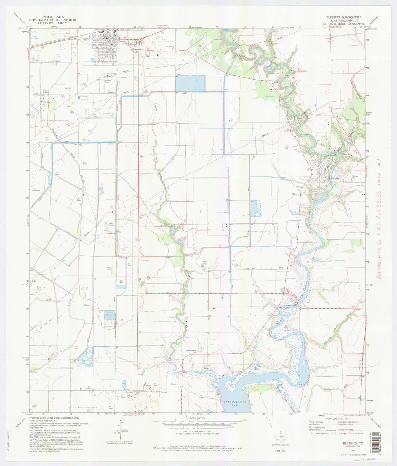
Matagorda County NRC Article 33.136 Location Key Sheet
Palacios Northeast Quadrangle
-
Map/Doc
87910
-
Collection
General Map Collection
-
Object Dates
1995 (Creation Date)
-
People and Organizations
U. S. Geological Survey (Publisher)
U. S. Geological Survey (Printer)
-
Counties
Matagorda
-
Subjects
Surveying CBS
-
Height x Width
27.0 x 23.0 inches
68.6 x 58.4 cm
Part of: General Map Collection
Parker County Boundary File 68

Print $12.00
- Digital $50.00
Parker County Boundary File 68
Size 8.1 x 3.6 inches
Map/Doc 57848
Winkler County

Print $20.00
- Digital $50.00
Winkler County
1901
Size 44.1 x 37.9 inches
Map/Doc 63131
Right of Way and Track Map, the Missouri, Kansas and Texas Ry. of Texas - Henrietta Division

Print $20.00
- Digital $50.00
Right of Way and Track Map, the Missouri, Kansas and Texas Ry. of Texas - Henrietta Division
1918
Size 11.8 x 26.9 inches
Map/Doc 64748
Hardin County Sketch File 70

Print $4.00
- Digital $50.00
Hardin County Sketch File 70
1895
Size 11.2 x 9.0 inches
Map/Doc 25257
Flight Mission No. BRA-8M, Frame 25, Jefferson County

Print $20.00
- Digital $50.00
Flight Mission No. BRA-8M, Frame 25, Jefferson County
1953
Size 18.4 x 22.5 inches
Map/Doc 85580
Flight Mission No. DQO-8K, Frame 74, Galveston County

Print $20.00
- Digital $50.00
Flight Mission No. DQO-8K, Frame 74, Galveston County
1952
Size 18.7 x 22.4 inches
Map/Doc 85178
Crane County Sketch File 3c

Print $6.00
- Digital $50.00
Crane County Sketch File 3c
1884
Size 12.8 x 7.9 inches
Map/Doc 19559
Galveston County NRC Article 33.136 Sketch 60

Print $88.00
- Digital $50.00
Galveston County NRC Article 33.136 Sketch 60
2009
Size 24.0 x 36.0 inches
Map/Doc 89263
Atascosa County

Print $20.00
- Digital $50.00
Atascosa County
1948
Size 47.2 x 46.3 inches
Map/Doc 95421
Cameron County Rolled Sketch 5

Print $20.00
- Digital $50.00
Cameron County Rolled Sketch 5
Size 35.8 x 38.8 inches
Map/Doc 8562
Collingsworth County

Print $20.00
- Digital $50.00
Collingsworth County
1971
Size 40.7 x 34.2 inches
Map/Doc 77243
Map of Hemisfair '68 and Downtown San Antonio compliments of the Pearl Brewing Company

Print $3.00
- Digital $50.00
Map of Hemisfair '68 and Downtown San Antonio compliments of the Pearl Brewing Company
1968
Size 5.9 x 11.3 inches
Map/Doc 94792
You may also like
Clay County Sketch File 22

Print $6.00
- Digital $50.00
Clay County Sketch File 22
Size 12.8 x 8.3 inches
Map/Doc 18436
King County Sketch File 7A

Print $28.00
- Digital $50.00
King County Sketch File 7A
1902
Size 22.1 x 34.7 inches
Map/Doc 11936
Kerr County Sketch File 23

Print $8.00
- Digital $50.00
Kerr County Sketch File 23
1959
Size 14.2 x 8.8 inches
Map/Doc 28901
[H. & G. N. Block 4]
![90268, [H. & G. N. Block 4], Twichell Survey Records](https://historictexasmaps.com/wmedia_w700/maps/90268-1.tif.jpg)
Print $20.00
- Digital $50.00
[H. & G. N. Block 4]
1887
Size 22.2 x 19.6 inches
Map/Doc 90268
Bosque County Rolled Sketch 3

Print $20.00
- Digital $50.00
Bosque County Rolled Sketch 3
Size 24.6 x 19.1 inches
Map/Doc 89015
Hopkins County Boundary File 3b

Print $4.00
- Digital $50.00
Hopkins County Boundary File 3b
Size 12.7 x 8.3 inches
Map/Doc 55084
University of Texas System University Lands

Print $20.00
- Digital $50.00
University of Texas System University Lands
1938
Size 23.4 x 17.9 inches
Map/Doc 93243
Val Verde County Working Sketch 89

Print $20.00
- Digital $50.00
Val Verde County Working Sketch 89
1974
Size 24.5 x 29.0 inches
Map/Doc 72224
Midland County Sketch File 19

Print $74.00
- Digital $50.00
Midland County Sketch File 19
1952
Size 11.1 x 8.7 inches
Map/Doc 31587
Cooke County Sketch File 9

Print $6.00
- Digital $50.00
Cooke County Sketch File 9
Size 8.2 x 10.5 inches
Map/Doc 19237
Frio County Working Sketch 18

Print $20.00
- Digital $50.00
Frio County Working Sketch 18
1982
Size 35.7 x 36.8 inches
Map/Doc 69292
Terrell County Working Sketch 32

Print $20.00
- Digital $50.00
Terrell County Working Sketch 32
1945
Size 33.0 x 36.9 inches
Map/Doc 62124