Bosque County Rolled Sketch 3
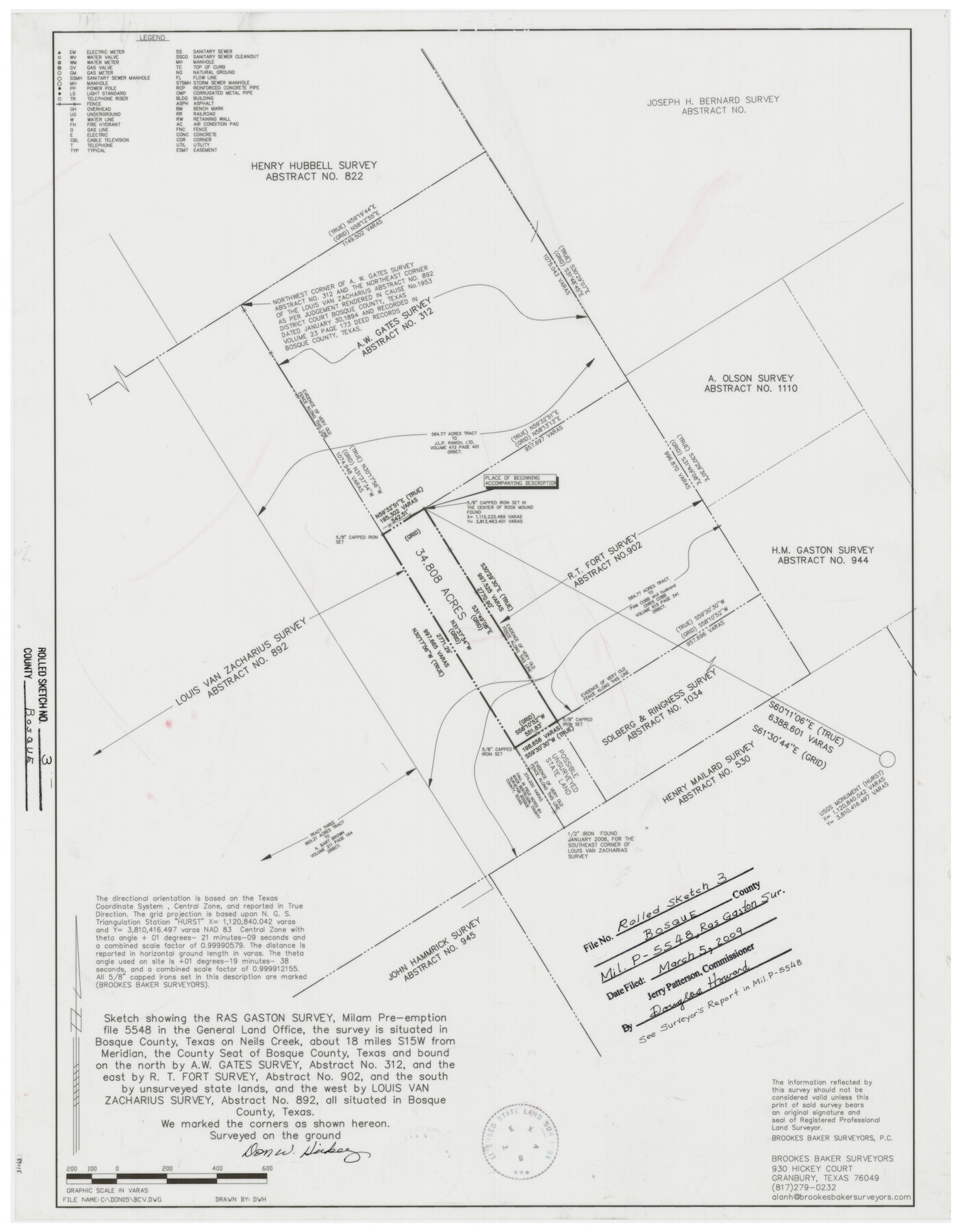
Sketch showing the Ras Gaston survey, Milam Pre-emption file 5548 in the General Land Office
-
Map/Doc
89015
-
Collection
General Map Collection
-
Object Dates
2009/3/5 (File Date)
-
People and Organizations
Don W. Hickey (Surveyor/Engineer)
-
Counties
Bosque
-
Subjects
Surveying Rolled Sketch
-
Height x Width
24.6 x 19.1 inches
62.5 x 48.5 cm
-
Medium
mylar, print
-
Comments
See surveyor's report in MIL P-5548
Part of: General Map Collection
Right of Way and Track Map, the Missouri, Kansas and Texas Ry. of Texas operated by the Missouri, Kansas and Texas Ry. of Texas, San Antonio Division

Print $40.00
- Digital $50.00
Right of Way and Track Map, the Missouri, Kansas and Texas Ry. of Texas operated by the Missouri, Kansas and Texas Ry. of Texas, San Antonio Division
1918
Size 25.3 x 58.3 inches
Map/Doc 64579
Harris County Rolled Sketch 102

Print $20.00
- Digital $50.00
Harris County Rolled Sketch 102
2009
Size 24.8 x 36.5 inches
Map/Doc 89585
Presidio County Sketch File 122

Print $22.00
- Digital $50.00
Presidio County Sketch File 122
2010
Size 11.0 x 8.5 inches
Map/Doc 89604
Ochiltree County Boundary File 4

Print $4.00
- Digital $50.00
Ochiltree County Boundary File 4
Size 11.1 x 8.7 inches
Map/Doc 57682
Wichita County Sketch File 33

Print $6.00
- Digital $50.00
Wichita County Sketch File 33
1949
Size 11.0 x 17.0 inches
Map/Doc 40152
Sherman County Working Sketch Graphic Index

Print $20.00
- Digital $50.00
Sherman County Working Sketch Graphic Index
1932
Size 41.5 x 36.9 inches
Map/Doc 76698
Tom Green County Sketch File 2

Print $4.00
- Digital $50.00
Tom Green County Sketch File 2
Size 9.6 x 7.6 inches
Map/Doc 38161
Bexar County Sketch File 53

Print $8.00
- Digital $50.00
Bexar County Sketch File 53
Size 11.4 x 8.9 inches
Map/Doc 14539
Zavala County

Print $20.00
- Digital $50.00
Zavala County
1915
Size 38.6 x 46.6 inches
Map/Doc 16940
Jackson County

Print $20.00
- Digital $50.00
Jackson County
1920
Size 46.9 x 40.1 inches
Map/Doc 95541
Crane County Working Sketch 1

Print $20.00
- Digital $50.00
Crane County Working Sketch 1
1906
Size 30.5 x 27.0 inches
Map/Doc 68278
Map of Hays County Travis District

Print $20.00
- Digital $50.00
Map of Hays County Travis District
1861
Size 18.6 x 26.0 inches
Map/Doc 3648
You may also like
Donley County Rolled Sketch 5

Print $40.00
- Digital $50.00
Donley County Rolled Sketch 5
1982
Size 56.6 x 32.9 inches
Map/Doc 8801
Chambers County Sketch File 39

Print $52.00
- Digital $50.00
Chambers County Sketch File 39
Size 11.0 x 6.6 inches
Map/Doc 17652
Frio County Working Sketch 11

Print $20.00
- Digital $50.00
Frio County Working Sketch 11
1952
Size 22.9 x 20.0 inches
Map/Doc 69285
Denton County Sketch File 29 1/2

Print $4.00
- Digital $50.00
Denton County Sketch File 29 1/2
Size 14.8 x 9.1 inches
Map/Doc 20758
Runnels County Working Sketch 32

Print $20.00
- Digital $50.00
Runnels County Working Sketch 32
1959
Size 27.7 x 24.0 inches
Map/Doc 63630
Williamson County Sketch File 17

Print $8.00
- Digital $50.00
Williamson County Sketch File 17
1876
Size 6.5 x 8.1 inches
Map/Doc 40338
Concho County Sketch File 33

Print $20.00
- Digital $50.00
Concho County Sketch File 33
1926
Size 13.4 x 18.1 inches
Map/Doc 11158
Blanco County Working Sketch 15

Print $20.00
- Digital $50.00
Blanco County Working Sketch 15
1950
Size 23.5 x 20.7 inches
Map/Doc 67375
Flight Mission No. CRC-5R, Frame 33, Chambers County

Print $20.00
- Digital $50.00
Flight Mission No. CRC-5R, Frame 33, Chambers County
1956
Size 18.6 x 22.5 inches
Map/Doc 84952
[Lgs. 180-183, 196-198, 105-112, 678-680, 699-701, 141-143]
![90153, [Lgs. 180-183, 196-198, 105-112, 678-680, 699-701, 141-143], Twichell Survey Records](https://historictexasmaps.com/wmedia_w700/maps/90153-1.tif.jpg)
Print $3.00
- Digital $50.00
[Lgs. 180-183, 196-198, 105-112, 678-680, 699-701, 141-143]
1913
Size 14.9 x 9.9 inches
Map/Doc 90153
Harris County Rolled Sketch 79

Print $20.00
- Digital $50.00
Harris County Rolled Sketch 79
1955
Size 30.4 x 25.0 inches
Map/Doc 6115
Presidio County Rolled Sketch 82

Print $20.00
- Digital $50.00
Presidio County Rolled Sketch 82
1943
Size 35.5 x 26.1 inches
Map/Doc 7369