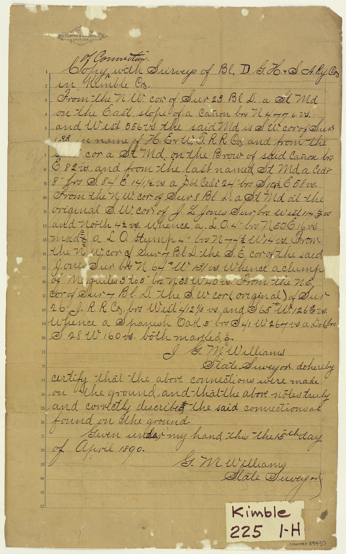
Copy of connection with surveys of Bl. D, GH&SA Ry. Co. in Kimble County
Kimble File 225 1-H
-
Map/Doc
89457
-
Collection
Barnes Railroad Collection
-
Object Dates
1890/4/15 (Creation Date)
-
People and Organizations
G.M. Williams (Surveyor/Engineer)
Randy Lea Barnes ()
-
Counties
Kimble
-
Subjects
Railroads
-
Height x Width
14.2 x 8.9 inches
36.1 x 22.6 cm
-
Medium
linen, manuscript
-
Comments
Measurements and description of property. Galveston, Harrisburg and San Antonio Railroad.
-
Features
GH&SA
Part of: Barnes Railroad Collection
[Hidalgo County]
![89517, [Hidalgo County], Barnes Railroad Collection](https://historictexasmaps.com/wmedia_w700/maps/89517.tif.jpg)
Print $20.00
- Digital $50.00
[Hidalgo County]
Size 44.7 x 26.0 inches
Map/Doc 89517

Copy of connection with surveys of Bl. D, GH&SA Ry. Co. in Kimble County

Print $6.00
- Digital $50.00
Copy of connection with surveys of Bl. D, GH&SA Ry. Co. in Kimble County
1890
Size 14.2 x 8.9 inches
Map/Doc 89457
[Railroad Map of Falfurias to Hidalgo, Hidalgo County]
![89422, [Railroad Map of Falfurias to Hidalgo, Hidalgo County], Barnes Railroad Collection](https://historictexasmaps.com/wmedia_w700/maps/89422-1.tif.jpg)
Print $40.00
- Digital $50.00
[Railroad Map of Falfurias to Hidalgo, Hidalgo County]
Size 25.0 x 146.5 inches
Map/Doc 89422
Map showing portion of 140 acre tract owned by Schriener Institute near Kerrville, Texas

Print $40.00
- Digital $50.00
Map showing portion of 140 acre tract owned by Schriener Institute near Kerrville, Texas
1922
Size 31.6 x 53.0 inches
Map/Doc 89443
[Knox County Blk. 44, H&TC]
![89463, [Knox County Blk. 44, H&TC], Barnes Railroad Collection](https://historictexasmaps.com/wmedia_w700/pdf_converted_jpg/qi_pdf_thumbnail_34701.jpg)
Print $42.00
- Digital $50.00
[Knox County Blk. 44, H&TC]
1892
Size 20.7 x 21.9 inches
Map/Doc 89463
You may also like
Smith County Working Sketch 13

Print $20.00
- Digital $50.00
Smith County Working Sketch 13
1962
Size 36.8 x 27.4 inches
Map/Doc 63898
Flight Mission No. DCL-7C, Frame 118, Kenedy County

Print $20.00
- Digital $50.00
Flight Mission No. DCL-7C, Frame 118, Kenedy County
1943
Size 18.4 x 22.3 inches
Map/Doc 86083
Parker County Working Sketch 21

Print $20.00
- Digital $50.00
Parker County Working Sketch 21
2006
Map/Doc 83655
Hutchinson County Rolled Sketch 15

Print $47.00
- Digital $50.00
Hutchinson County Rolled Sketch 15
1911
Size 28.9 x 27.0 inches
Map/Doc 10201
Uvalde County Working Sketch 28

Print $20.00
- Digital $50.00
Uvalde County Working Sketch 28
1957
Size 25.9 x 21.5 inches
Map/Doc 72098
Flight Mission No. BQR-20K, Frame 13, Brazoria County

Print $20.00
- Digital $50.00
Flight Mission No. BQR-20K, Frame 13, Brazoria County
1952
Size 18.6 x 22.3 inches
Map/Doc 84115
Trinity River, Eagle Ford Sheet/Trinity and Elm Fork of Trinity River

Print $20.00
- Digital $50.00
Trinity River, Eagle Ford Sheet/Trinity and Elm Fork of Trinity River
1917
Size 29.5 x 23.2 inches
Map/Doc 69685
St. Louis, Brownsville & Mexico

Print $40.00
- Digital $50.00
St. Louis, Brownsville & Mexico
1906
Size 21.2 x 130.5 inches
Map/Doc 89280
Leon County Working Sketch 55

Print $20.00
- Digital $50.00
Leon County Working Sketch 55
1989
Size 18.7 x 18.3 inches
Map/Doc 70455
Irion County Working Sketch 13

Print $40.00
- Digital $50.00
Irion County Working Sketch 13
1968
Size 88.1 x 31.6 inches
Map/Doc 66422
A Topographical Map of the City of Austin

Print $20.00
- Digital $50.00
A Topographical Map of the City of Austin
1872
Size 21.0 x 14.7 inches
Map/Doc 4821
[Surveys along the Nueces River, San Patricio District]
![69739, [Surveys along the Nueces River, San Patricio District], General Map Collection](https://historictexasmaps.com/wmedia_w700/maps/69739.tif.jpg)
Print $2.00
- Digital $50.00
[Surveys along the Nueces River, San Patricio District]
1842
Size 11.3 x 7.7 inches
Map/Doc 69739