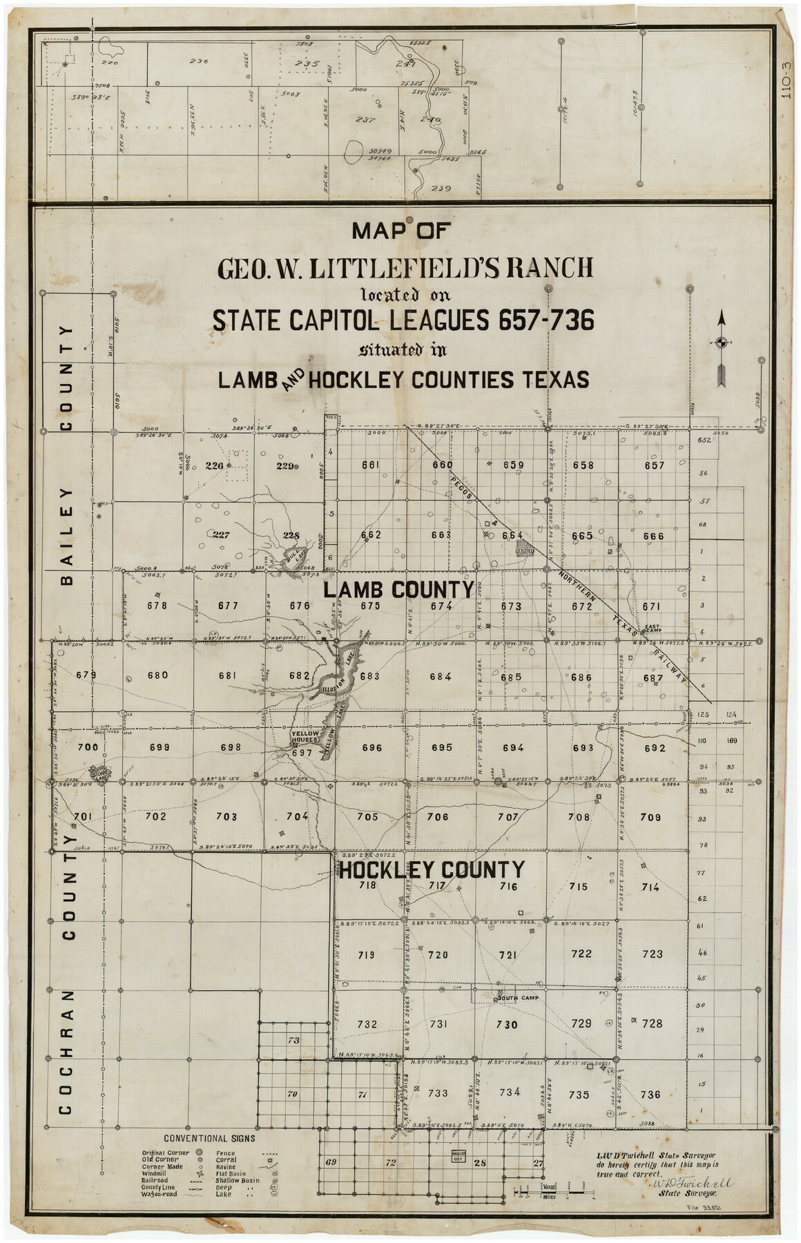
Map of Geo. W. Littlefield's Ranch Located on State Capitol Leagues 657-736 Situated in Lamb and Hockley Counties
110-3
-
Map/Doc
91223
-
Collection
Twichell Survey Records
-
People and Organizations
W.D. Twichell (Surveyor/Engineer)
-
Counties
Lamb Hockley
-
Height x Width
29.7 x 45.6 inches
75.4 x 115.8 cm
Part of: Twichell Survey Records
[North County Line]
![90522, [North County Line], Twichell Survey Records](https://historictexasmaps.com/wmedia_w700/maps/90522-1.tif.jpg)
Print $20.00
- Digital $50.00
[North County Line]
Size 18.5 x 7.0 inches
Map/Doc 90522
Map of Glasscock County

Print $20.00
- Digital $50.00
Map of Glasscock County
Size 18.8 x 25.1 inches
Map/Doc 90783
[Sketch showing PSL Block AX and C. C. S. D. & R. G. N. G. RR. Co. Block G]
![90838, [Sketch showing PSL Block AX and C. C. S. D. & R. G. N. G. RR. Co. Block G], Twichell Survey Records](https://historictexasmaps.com/wmedia_w700/maps/90838-2.tif.jpg)
Print $20.00
- Digital $50.00
[Sketch showing PSL Block AX and C. C. S. D. & R. G. N. G. RR. Co. Block G]
Size 25.8 x 16.6 inches
Map/Doc 90838
Gomez Section 1, Block D-12

Print $20.00
- Digital $50.00
Gomez Section 1, Block D-12
1955
Size 15.8 x 16.8 inches
Map/Doc 92321
[K. N. Hapgood's Pasture and surrounding surveys]
![90432, [K. N. Hapgood's Pasture and surrounding surveys], Twichell Survey Records](https://historictexasmaps.com/wmedia_w700/maps/90432-1.tif.jpg)
Print $2.00
- Digital $50.00
[K. N. Hapgood's Pasture and surrounding surveys]
1923
Size 8.7 x 11.5 inches
Map/Doc 90432
![92632, [League 280], Twichell Survey Records](https://historictexasmaps.com/wmedia_w700/maps/92632-1.tif.jpg)
Map of Block 1, H. & G. N. RR. Co.

Print $20.00
- Digital $50.00
Map of Block 1, H. & G. N. RR. Co.
1908
Size 26.3 x 32.0 inches
Map/Doc 90899
Amherst Independent School District Situated in Lamb County, Texas

Print $20.00
- Digital $50.00
Amherst Independent School District Situated in Lamb County, Texas
Size 25.0 x 18.9 inches
Map/Doc 92203
[Block M-19, and G. & M. Blocks 4 and 5]
![91784, [Block M-19, and G. & M. Blocks 4 and 5], Twichell Survey Records](https://historictexasmaps.com/wmedia_w700/maps/91784-1.tif.jpg)
Print $20.00
- Digital $50.00
[Block M-19, and G. & M. Blocks 4 and 5]
Size 22.4 x 17.7 inches
Map/Doc 91784
[Blk. B, Secs. 111-114 and vicinity]
![90340, [Blk. B, Secs. 111-114 and vicinity], Twichell Survey Records](https://historictexasmaps.com/wmedia_w700/maps/90340-1.tif.jpg)
Print $20.00
- Digital $50.00
[Blk. B, Secs. 111-114 and vicinity]
Size 31.3 x 38.7 inches
Map/Doc 90340
Eastern Heights Addition - Preliminary Plat Showing Subdivision of SW/4 of SW/4 - Sectin 5 Block O as Proposed by Mr. H. Sieber 38.43 Ac.

Print $20.00
- Digital $50.00
Eastern Heights Addition - Preliminary Plat Showing Subdivision of SW/4 of SW/4 - Sectin 5 Block O as Proposed by Mr. H. Sieber 38.43 Ac.
1952
Size 23.8 x 19.8 inches
Map/Doc 92811
Map of Stephens County, Texas

Print $20.00
- Digital $50.00
Map of Stephens County, Texas
Size 36.8 x 40.1 inches
Map/Doc 93026
You may also like
Montgomery County Working Sketch 10

Print $20.00
- Digital $50.00
Montgomery County Working Sketch 10
1933
Size 36.5 x 38.6 inches
Map/Doc 71117
La Salle County Sketch File 19

Print $32.00
- Digital $50.00
La Salle County Sketch File 19
1885
Size 14.2 x 8.7 inches
Map/Doc 29509
Matagorda Bay and Approaches

Print $20.00
- Digital $50.00
Matagorda Bay and Approaches
1961
Size 35.0 x 45.0 inches
Map/Doc 73382
Cameron County Aerial Photograph Index Sheet 3

Print $20.00
- Digital $50.00
Cameron County Aerial Photograph Index Sheet 3
1955
Size 21.1 x 17.4 inches
Map/Doc 83675
Travis County Boundary File 2

Print $42.00
- Digital $50.00
Travis County Boundary File 2
Size 9.3 x 7.2 inches
Map/Doc 59406
[Jack County School Land, Limestone County School Land and surveys in vicinity]
![90433, [Jack County School Land, Limestone County School Land and surveys in vicinity], Twichell Survey Records](https://historictexasmaps.com/wmedia_w700/maps/90433-1.tif.jpg)
Print $3.00
- Digital $50.00
[Jack County School Land, Limestone County School Land and surveys in vicinity]
1892
Size 10.2 x 15.1 inches
Map/Doc 90433
The Republic County of Bexar. December 2, 1841

Print $20.00
The Republic County of Bexar. December 2, 1841
2020
Size 14.8 x 21.7 inches
Map/Doc 96098
Webb County Rolled Sketch 20

Print $20.00
- Digital $50.00
Webb County Rolled Sketch 20
1928
Size 38.1 x 29.0 inches
Map/Doc 8182
Titus County Working Sketch 7

Print $20.00
- Digital $50.00
Titus County Working Sketch 7
1970
Size 31.5 x 28.7 inches
Map/Doc 69368
Working Sketch, Goliad & Bee Counties

Print $20.00
- Digital $50.00
Working Sketch, Goliad & Bee Counties
1936
Size 35.0 x 43.1 inches
Map/Doc 2453
Flight Mission No. DQN-1K, Frame 125, Calhoun County

Print $20.00
- Digital $50.00
Flight Mission No. DQN-1K, Frame 125, Calhoun County
1953
Size 18.4 x 22.1 inches
Map/Doc 84191
Crockett County Working Sketch 94

Print $20.00
- Digital $50.00
Crockett County Working Sketch 94
1979
Size 43.1 x 28.7 inches
Map/Doc 68427