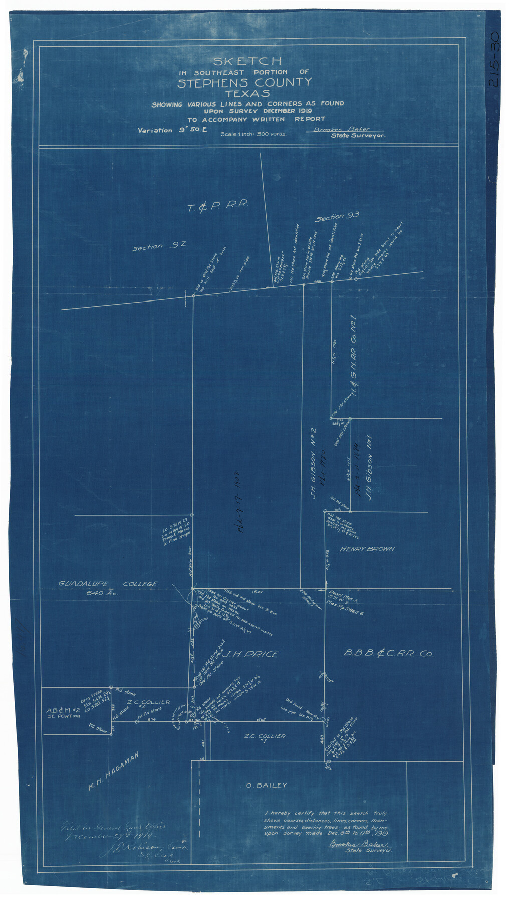
Sketch in Southeast Portion of Stephens County, Texas showing various lines and corners as found upon survey
215-30
-
Map/Doc
91842
-
Collection
Twichell Survey Records
-
Object Dates
12/11/1919 (Creation Date)
-
People and Organizations
Brookes Baker (Surveyor/Engineer)
-
Counties
Stephens
-
Height x Width
19.2 x 34.3 inches
48.8 x 87.1 cm
Part of: Twichell Survey Records
[Sketch Showing Wm. T. Brewer, John R. Taylor, Wm. F. Butler, Timothy DeVore, L. M. Thorn and adjoining surveys]
![89745, [Sketch Showing Wm. T. Brewer, John R. Taylor, Wm. F. Butler, Timothy DeVore, L. M. Thorn and adjoining surveys], Twichell Survey Records](https://historictexasmaps.com/wmedia_w700/maps/89745-1.tif.jpg)
Print $40.00
- Digital $50.00
[Sketch Showing Wm. T. Brewer, John R. Taylor, Wm. F. Butler, Timothy DeVore, L. M. Thorn and adjoining surveys]
Size 37.1 x 56.1 inches
Map/Doc 89745
Lubbock County Lines

Print $20.00
- Digital $50.00
Lubbock County Lines
1892
Size 22.7 x 22.6 inches
Map/Doc 91308
[Sketch of Block A1 in Hartley County]
![90762, [Sketch of Block A1 in Hartley County], Twichell Survey Records](https://historictexasmaps.com/wmedia_w700/maps/90762-1.tif.jpg)
Print $20.00
- Digital $50.00
[Sketch of Block A1 in Hartley County]
1902
Size 11.3 x 21.4 inches
Map/Doc 90762
[Blks. Z, C4, 194, 178, C3, A2, 179 and 207]
![89837, [Blks. Z, C4, 194, 178, C3, A2, 179 and 207], Twichell Survey Records](https://historictexasmaps.com/wmedia_w700/maps/89837-1.tif.jpg)
Print $40.00
- Digital $50.00
[Blks. Z, C4, 194, 178, C3, A2, 179 and 207]
Size 61.6 x 37.5 inches
Map/Doc 89837
[Surrounding McCrummens Second Addition]
![92839, [Surrounding McCrummens Second Addition], Twichell Survey Records](https://historictexasmaps.com/wmedia_w700/maps/92839-1.tif.jpg)
Print $20.00
- Digital $50.00
[Surrounding McCrummens Second Addition]
Size 31.2 x 33.1 inches
Map/Doc 92839
Map of Escarpment Section through Webb County, Texas (North half of Webb County)

Print $40.00
- Digital $50.00
Map of Escarpment Section through Webb County, Texas (North half of Webb County)
1925
Size 43.3 x 76.3 inches
Map/Doc 93162
Sketch Showing Portion of League 4, Wilson County School Land in Lynn County

Print $20.00
- Digital $50.00
Sketch Showing Portion of League 4, Wilson County School Land in Lynn County
Size 20.9 x 22.6 inches
Map/Doc 92941
[Sketch of Survey 9, Block Z3]
![93089, [Sketch of Survey 9, Block Z3], Twichell Survey Records](https://historictexasmaps.com/wmedia_w700/maps/93089-1.tif.jpg)
Print $2.00
- Digital $50.00
[Sketch of Survey 9, Block Z3]
Size 8.9 x 7.3 inches
Map/Doc 93089
[Connection to Block M-13]
![93040, [Connection to Block M-13], Twichell Survey Records](https://historictexasmaps.com/wmedia_w700/maps/93040-1.tif.jpg)
Print $40.00
- Digital $50.00
[Connection to Block M-13]
Size 27.1 x 60.0 inches
Map/Doc 93040
F. Z. Bishop's Subdivision of C. C. Slaughter Ranch

Print $20.00
- Digital $50.00
F. Z. Bishop's Subdivision of C. C. Slaughter Ranch
Size 20.6 x 19.2 inches
Map/Doc 92305
[Sketch showing PSL Block AX and C. C. S. D. & R. G. N. G. RR. Co. Block G]
![90838, [Sketch showing PSL Block AX and C. C. S. D. & R. G. N. G. RR. Co. Block G], Twichell Survey Records](https://historictexasmaps.com/wmedia_w700/maps/90838-2.tif.jpg)
Print $20.00
- Digital $50.00
[Sketch showing PSL Block AX and C. C. S. D. & R. G. N. G. RR. Co. Block G]
Size 25.8 x 16.6 inches
Map/Doc 90838
[I. & G. N. Block 1, Runnels County School Land and adjacent areas]
![91615, [I. & G. N. Block 1, Runnels County School Land and adjacent areas], Twichell Survey Records](https://historictexasmaps.com/wmedia_w700/maps/91615-1.tif.jpg)
Print $20.00
- Digital $50.00
[I. & G. N. Block 1, Runnels County School Land and adjacent areas]
Size 34.2 x 28.0 inches
Map/Doc 91615
You may also like
Coryell County Sketch File 8

Print $6.00
- Digital $50.00
Coryell County Sketch File 8
1853
Size 16.0 x 10.2 inches
Map/Doc 19357
Jefferson County NRC Article 33.136 Location Key Sheet

Print $20.00
- Digital $50.00
Jefferson County NRC Article 33.136 Location Key Sheet
1974
Size 27.0 x 23.0 inches
Map/Doc 77029
Tyler County Sketch File 9

Print $4.00
- Digital $50.00
Tyler County Sketch File 9
Size 8.6 x 6.7 inches
Map/Doc 38644
Flight Mission No. DCL-6C, Frame 95, Kenedy County

Print $20.00
- Digital $50.00
Flight Mission No. DCL-6C, Frame 95, Kenedy County
1943
Size 18.6 x 22.3 inches
Map/Doc 85925
Frio County Working Sketch 10

Print $20.00
- Digital $50.00
Frio County Working Sketch 10
1951
Size 27.0 x 27.3 inches
Map/Doc 69284
Flight Mission No. CUG-1P, Frame 86, Kleberg County

Print $20.00
- Digital $50.00
Flight Mission No. CUG-1P, Frame 86, Kleberg County
1956
Size 18.5 x 22.2 inches
Map/Doc 86151

[Cotton Belt, St. Louis Southwestern Railway of Texas, Alignment through Smith County]
![64374, [Cotton Belt, St. Louis Southwestern Railway of Texas, Alignment through Smith County], General Map Collection](https://historictexasmaps.com/wmedia_w700/maps/64374.tif.jpg)
Print $20.00
- Digital $50.00
[Cotton Belt, St. Louis Southwestern Railway of Texas, Alignment through Smith County]
1903
Size 21.5 x 29.3 inches
Map/Doc 64374
Crockett County Working Sketch 48

Print $20.00
- Digital $50.00
Crockett County Working Sketch 48
1938
Size 23.8 x 13.2 inches
Map/Doc 68381
Robertson County Sketch File 10

Print $22.00
Robertson County Sketch File 10
1846
Size 12.8 x 8.4 inches
Map/Doc 35392
Orange County Rolled Sketch 13

Print $20.00
- Digital $50.00
Orange County Rolled Sketch 13
Size 19.0 x 24.2 inches
Map/Doc 7180
Flight Mission No. BRA-8M, Frame 79, Jefferson County

Print $20.00
- Digital $50.00
Flight Mission No. BRA-8M, Frame 79, Jefferson County
1953
Size 15.8 x 15.5 inches
Map/Doc 85599