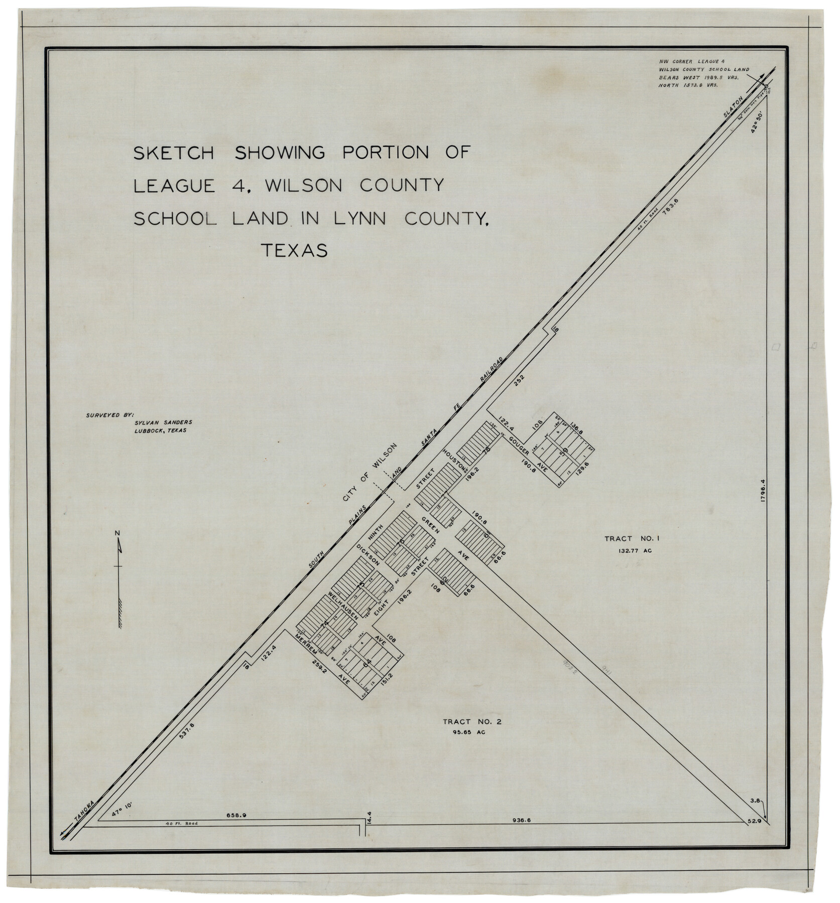
Sketch Showing Portion of League 4, Wilson County School Land in Lynn County
-
Map/Doc
92941
-
Collection
Twichell Survey Records
-
People and Organizations
Sylvan Sanders (Surveyor/Engineer)
-
Counties
Lynn
-
Height x Width
20.9 x 22.6 inches
53.1 x 57.4 cm
Part of: Twichell Survey Records
Working Sketch, Garza County

Print $20.00
- Digital $50.00
Working Sketch, Garza County
1904
Size 13.9 x 14.7 inches
Map/Doc 92693
[Parts of PSL Blocks B18, B19, B28, B20 and B29]
![91952, [Parts of PSL Blocks B18, B19, B28, B20 and B29], Twichell Survey Records](https://historictexasmaps.com/wmedia_w700/maps/91952-1.tif.jpg)
Print $20.00
- Digital $50.00
[Parts of PSL Blocks B18, B19, B28, B20 and B29]
Size 21.4 x 28.0 inches
Map/Doc 91952
[Blocks M19, M3 & M20]
![91819, [Blocks M19, M3 & M20], Twichell Survey Records](https://historictexasmaps.com/wmedia_w700/maps/91819-1.tif.jpg)
Print $20.00
- Digital $50.00
[Blocks M19, M3 & M20]
Size 47.3 x 20.0 inches
Map/Doc 91819
Map of a Part of Lea County, New Mexico

Print $40.00
- Digital $50.00
Map of a Part of Lea County, New Mexico
Size 60.5 x 42.0 inches
Map/Doc 89910

[Southern Part of County]
![91905, [Southern Part of County], Twichell Survey Records](https://historictexasmaps.com/wmedia_w700/maps/91905-1.tif.jpg)
Print $2.00
- Digital $50.00
[Southern Part of County]
Size 9.8 x 7.6 inches
Map/Doc 91905
Lubbock County Sketch

Print $20.00
- Digital $50.00
Lubbock County Sketch
1945
Size 19.0 x 29.8 inches
Map/Doc 92797
"L" Sketch from Ward and Crane Cos.

Print $20.00
- Digital $50.00
"L" Sketch from Ward and Crane Cos.
Size 28.7 x 20.8 inches
Map/Doc 91961
[Block RG, Block C, San Augustine School Land]
![92863, [Block RG, Block C, San Augustine School Land], Twichell Survey Records](https://historictexasmaps.com/wmedia_w700/maps/92863-1.tif.jpg)
Print $20.00
- Digital $50.00
[Block RG, Block C, San Augustine School Land]
Size 32.8 x 38.7 inches
Map/Doc 92863
Famous Heights Addn. Amarillo, Texas

Print $2.00
- Digital $50.00
Famous Heights Addn. Amarillo, Texas
Size 8.3 x 9.8 inches
Map/Doc 91700
South Part Brewster Co.

Print $40.00
- Digital $50.00
South Part Brewster Co.
1915
Size 50.0 x 35.2 inches
Map/Doc 89723
[North line of T. & P. Block 31, Township 6N]
![90554, [North line of T. & P. Block 31, Township 6N], Twichell Survey Records](https://historictexasmaps.com/wmedia_w700/maps/90554-1.tif.jpg)
Print $2.00
- Digital $50.00
[North line of T. & P. Block 31, Township 6N]
Size 7.5 x 4.7 inches
Map/Doc 90554
You may also like
Interpretative map of wind erodibility. Gaines County, Texas

Interpretative map of wind erodibility. Gaines County, Texas
1986
Size 27.6 x 36.2 inches
Map/Doc 93561

[Blocks 1, 2, 8, B4, B5 and others in vicinity]
![91816, [Blocks 1, 2, 8, B4, B5 and others in vicinity], Twichell Survey Records](https://historictexasmaps.com/wmedia_w700/maps/91816-1.tif.jpg)
Print $20.00
- Digital $50.00
[Blocks 1, 2, 8, B4, B5 and others in vicinity]
Size 29.1 x 32.6 inches
Map/Doc 91816
Fannin County Boundary File 10a and 10b and 10c

Print $2.00
- Digital $50.00
Fannin County Boundary File 10a and 10b and 10c
Size 11.2 x 9.1 inches
Map/Doc 53327
Jackson County Boundary File 1

Print $24.00
- Digital $50.00
Jackson County Boundary File 1
Size 9.0 x 3.9 inches
Map/Doc 55420
Map of Texas compiled from surveys recorded in the Land Office of Texas, and other official surveys

Print $20.00
Map of Texas compiled from surveys recorded in the Land Office of Texas, and other official surveys
1841
Size 25.1 x 20.4 inches
Map/Doc 76253
Montgomery County Rolled Sketch 42

Print $20.00
- Digital $50.00
Montgomery County Rolled Sketch 42
1939
Size 14.1 x 20.3 inches
Map/Doc 6815
San Patricio County Rolled Sketch 54

Print $20.00
- Digital $50.00
San Patricio County Rolled Sketch 54
1995
Size 25.3 x 36.5 inches
Map/Doc 7740
Ector County Working Sketch 33

Print $20.00
- Digital $50.00
Ector County Working Sketch 33
1982
Size 24.7 x 29.0 inches
Map/Doc 68876
T. L. Morris Farm Rt. 6

Print $20.00
- Digital $50.00
T. L. Morris Farm Rt. 6
Size 16.3 x 13.2 inches
Map/Doc 92341
Edwards County Rolled Sketch 33

Print $20.00
- Digital $50.00
Edwards County Rolled Sketch 33
1890
Size 25.0 x 25.8 inches
Map/Doc 5815
Somervell County

Print $20.00
- Digital $50.00
Somervell County
1941
Size 29.2 x 27.1 inches
Map/Doc 95642