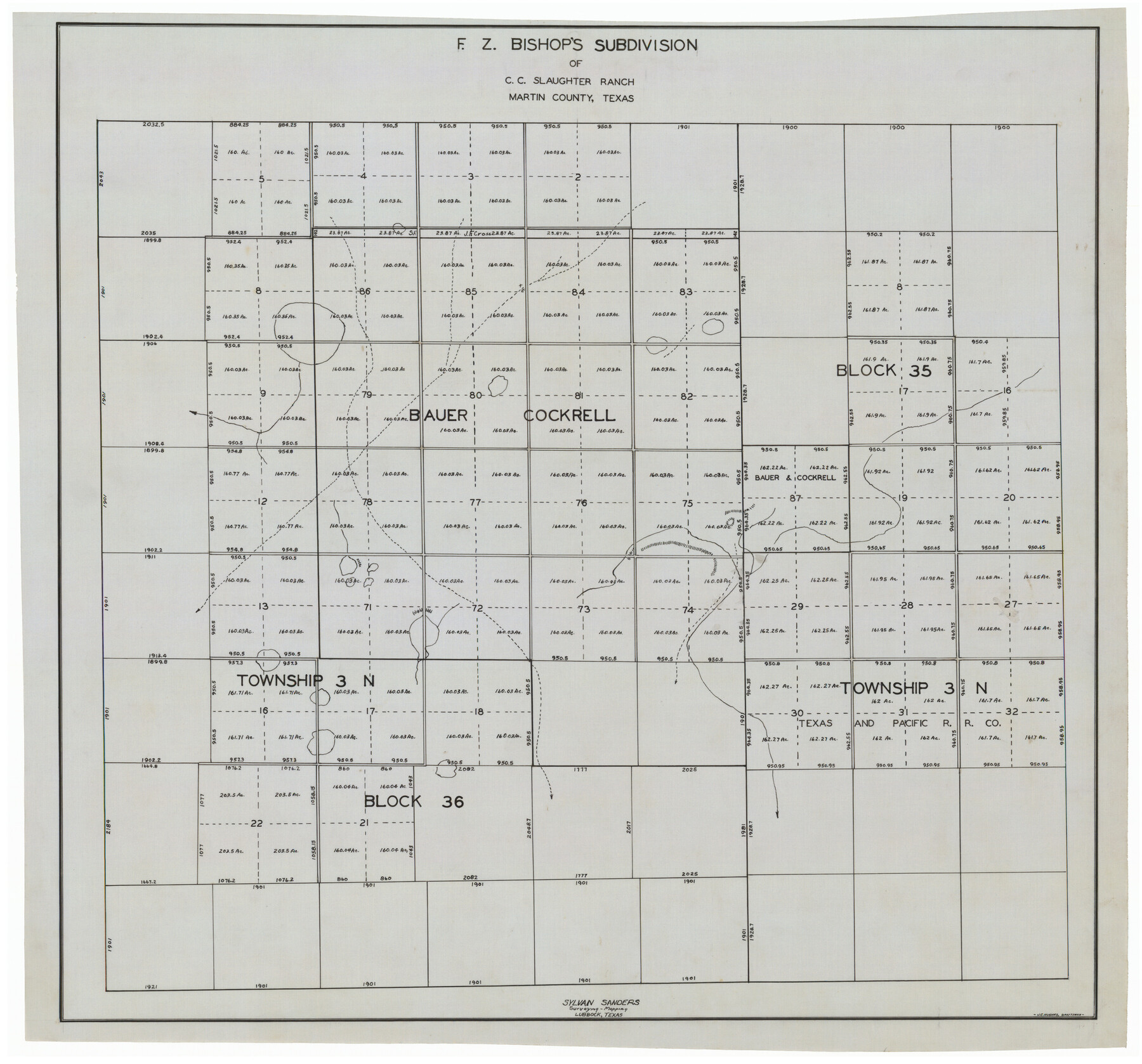
F. Z. Bishop's Subdivision of C. C. Slaughter Ranch
-
Map/Doc
92305
-
Collection
Twichell Survey Records
-
People and Organizations
Sylvan Sanders (Surveyor/Engineer)
J.C. Hughes (Draftsman)
-
Counties
Martin
-
Height x Width
20.6 x 19.2 inches
52.3 x 48.8 cm
Part of: Twichell Survey Records
Famous Heights Addition to Amarillo, Potter Co. Texas

Print $20.00
- Digital $50.00
Famous Heights Addition to Amarillo, Potter Co. Texas
Size 18.6 x 10.0 inches
Map/Doc 91744
[Leagues 589-598, 627-630, part of Black Water Pasture]
![90259, [Leagues 589-598, 627-630, part of Black Water Pasture], Twichell Survey Records](https://historictexasmaps.com/wmedia_w700/maps/90259-1.tif.jpg)
Print $3.00
- Digital $50.00
[Leagues 589-598, 627-630, part of Black Water Pasture]
Size 14.5 x 11.5 inches
Map/Doc 90259
Soash-White Industrial Properties

Print $20.00
- Digital $50.00
Soash-White Industrial Properties
Size 37.4 x 24.9 inches
Map/Doc 92776
Abernathy Quadrangle

Print $20.00
- Digital $50.00
Abernathy Quadrangle
Size 17.6 x 21.4 inches
Map/Doc 92813
[T. & N. O. Railroad Company Blocks 2T and 3T]
![91489, [T. & N. O. Railroad Company Blocks 2T and 3T], Twichell Survey Records](https://historictexasmaps.com/wmedia_w700/maps/91489-1.tif.jpg)
Print $20.00
- Digital $50.00
[T. & N. O. Railroad Company Blocks 2T and 3T]
Size 24.4 x 8.8 inches
Map/Doc 91489
Dr. S. C. Arnett Farm Part Section 22, Block JS

Print $20.00
- Digital $50.00
Dr. S. C. Arnett Farm Part Section 22, Block JS
Size 16.0 x 18.7 inches
Map/Doc 92306
Ownership Map Lamb County

Print $20.00
- Digital $50.00
Ownership Map Lamb County
1934
Size 37.6 x 45.0 inches
Map/Doc 89847
[Sketch showing North line of James Stewart survey and vicinity]
![90116, [Sketch showing North line of James Stewart survey and vicinity], Twichell Survey Records](https://historictexasmaps.com/wmedia_w700/maps/90116-1.tif.jpg)
Print $20.00
- Digital $50.00
[Sketch showing North line of James Stewart survey and vicinity]
Size 30.0 x 9.0 inches
Map/Doc 90116
![91836, [Block IT], Twichell Survey Records](https://historictexasmaps.com/wmedia_w700/maps/91836-1.tif.jpg)
Map of Independence Area, Washington County, Texas

Print $20.00
- Digital $50.00
Map of Independence Area, Washington County, Texas
1935
Size 24.0 x 19.1 inches
Map/Doc 91989
Hutchinson County

Print $20.00
- Digital $50.00
Hutchinson County
1922
Size 14.8 x 17.9 inches
Map/Doc 92168
[Part of Eastern Texas RR. Co. Block 1]
![91921, [Part of Eastern Texas RR. Co. Block 1], Twichell Survey Records](https://historictexasmaps.com/wmedia_w700/maps/91921-1.tif.jpg)
Print $20.00
- Digital $50.00
[Part of Eastern Texas RR. Co. Block 1]
Size 23.9 x 43.1 inches
Map/Doc 91921
You may also like
Red River County Working Sketch 60

Print $20.00
- Digital $50.00
Red River County Working Sketch 60
1973
Size 27.1 x 40.0 inches
Map/Doc 72043
[Gulf Coast portion of] Map of the State of Texas
![72707, [Gulf Coast portion of] Map of the State of Texas, General Map Collection](https://historictexasmaps.com/wmedia_w700/maps/72707.tif.jpg)
Print $20.00
- Digital $50.00
[Gulf Coast portion of] Map of the State of Texas
1865
Size 27.4 x 18.1 inches
Map/Doc 72707
Comanche County Boundary File 2b

Print $12.00
- Digital $50.00
Comanche County Boundary File 2b
Size 14.3 x 8.9 inches
Map/Doc 51790
Runnels County Boundary File 1

Print $42.00
- Digital $50.00
Runnels County Boundary File 1
Size 9.3 x 7.7 inches
Map/Doc 58504
Kendall County Working Sketch 7

Print $20.00
- Digital $50.00
Kendall County Working Sketch 7
1950
Size 30.8 x 32.4 inches
Map/Doc 66679
General Highway Map. Detail of Cities and Towns in Grayson County, Texas [Denison and Sherman]
![79487, General Highway Map. Detail of Cities and Towns in Grayson County, Texas [Denison and Sherman], Texas State Library and Archives](https://historictexasmaps.com/wmedia_w700/maps/79487.tif.jpg)
Print $20.00
General Highway Map. Detail of Cities and Towns in Grayson County, Texas [Denison and Sherman]
1961
Size 18.2 x 24.6 inches
Map/Doc 79487
Flight Mission No. BRA-7M, Frame 137, Jefferson County

Print $20.00
- Digital $50.00
Flight Mission No. BRA-7M, Frame 137, Jefferson County
1953
Size 18.7 x 22.4 inches
Map/Doc 85531
Travis County Appraisal District Plat Map 2_3216

Print $20.00
- Digital $50.00
Travis County Appraisal District Plat Map 2_3216
Size 21.5 x 26.4 inches
Map/Doc 94223
[Tie line from Northeast Block 36, Township 5N to Northwest corner Block M]
![90559, [Tie line from Northeast Block 36, Township 5N to Northwest corner Block M], Twichell Survey Records](https://historictexasmaps.com/wmedia_w700/maps/90559-1.tif.jpg)
Print $20.00
- Digital $50.00
[Tie line from Northeast Block 36, Township 5N to Northwest corner Block M]
Size 22.3 x 10.3 inches
Map/Doc 90559
Harris County NRC Article 33.136 Sketch 12

Print $30.00
- Digital $50.00
Harris County NRC Article 33.136 Sketch 12
2007
Size 24.0 x 17.5 inches
Map/Doc 94627
Hemphill County Working Sketch 34

Print $40.00
- Digital $50.00
Hemphill County Working Sketch 34
1976
Size 33.9 x 64.2 inches
Map/Doc 66129
El Paso County Boundary File 22

Print $4.00
- Digital $50.00
El Paso County Boundary File 22
Size 13.6 x 8.6 inches
Map/Doc 53216