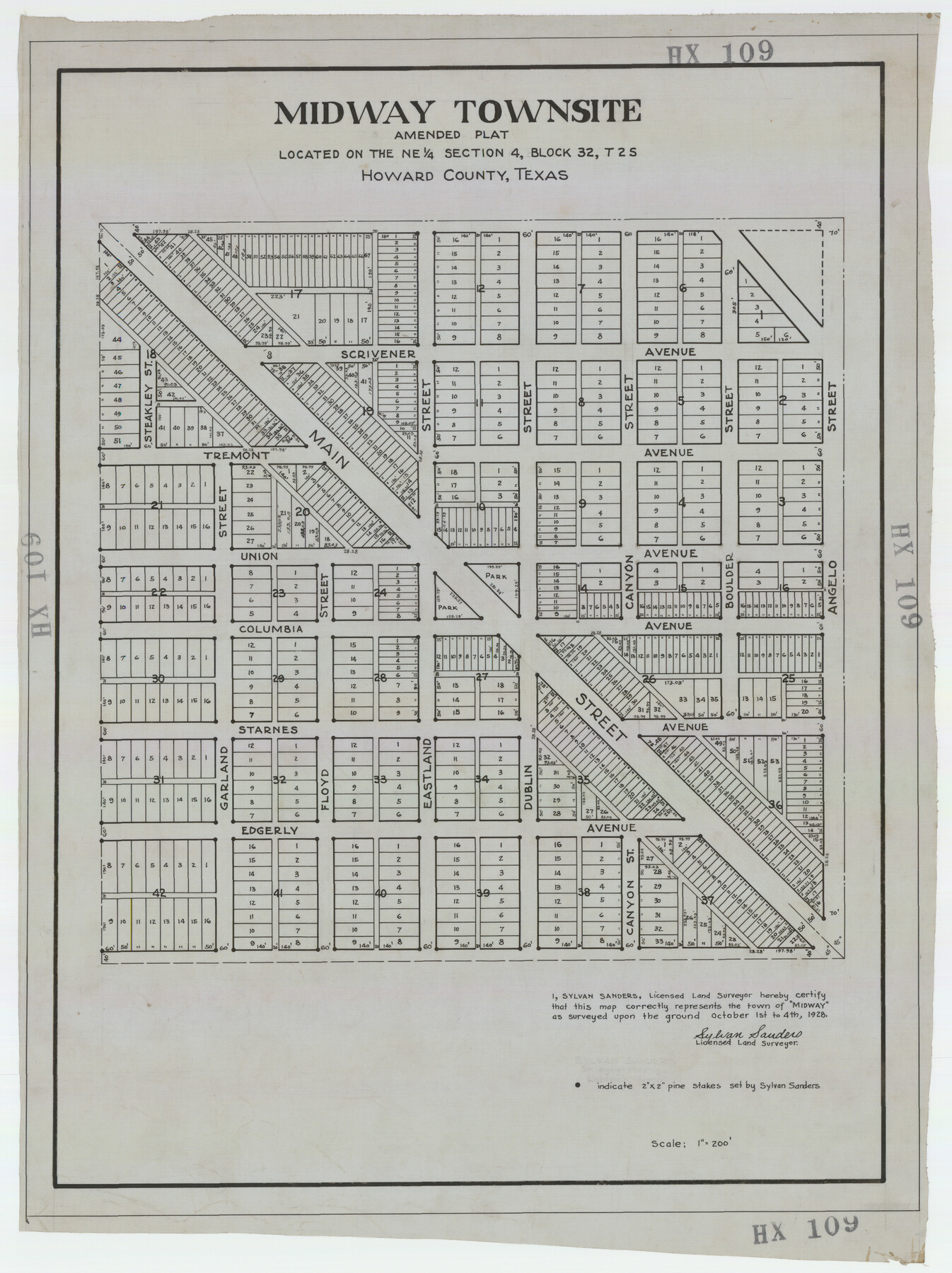
Midway Townsite Located on the Northeast Quarter Section 4, Block 32, T 2 S, Howard County, Texas
HX109
-
Map/Doc
92184
-
Collection
Twichell Survey Records
-
Object Dates
10/4/1928 (Creation Date)
-
People and Organizations
Sylvan Sanders (Surveyor/Engineer)
-
Counties
Howard
-
Height x Width
11.4 x 15.3 inches
29.0 x 38.9 cm
Part of: Twichell Survey Records
[Kent County Block 4, Sections 33 and 46, Block 97, Sections 771 and 772]
![92192, [Kent County Block 4, Sections 33 and 46, Block 97, Sections 771 and 772], Twichell Survey Records](https://historictexasmaps.com/wmedia_w700/maps/92192-1.tif.jpg)
Print $2.00
- Digital $50.00
[Kent County Block 4, Sections 33 and 46, Block 97, Sections 771 and 772]
1951
Size 8.7 x 15.6 inches
Map/Doc 92192
Olton, Texas Voted County Seat of Lamb County

Print $20.00
- Digital $50.00
Olton, Texas Voted County Seat of Lamb County
Size 23.2 x 24.1 inches
Map/Doc 92151
[Area north of League 1, Morris County School Land]
![90351, [Area north of League 1, Morris County School Land], Twichell Survey Records](https://historictexasmaps.com/wmedia_w700/maps/90351-1.tif.jpg)
Print $20.00
- Digital $50.00
[Area north of League 1, Morris County School Land]
Size 12.9 x 14.1 inches
Map/Doc 90351
[I. & G. N. Block 1, sections 57-70]
![91668, [I. & G. N. Block 1, sections 57-70], Twichell Survey Records](https://historictexasmaps.com/wmedia_w700/maps/91668-1.tif.jpg)
Print $20.00
- Digital $50.00
[I. & G. N. Block 1, sections 57-70]
Size 28.8 x 22.1 inches
Map/Doc 91668
[John W. Carpenter and Surrounding Surveys]
![91085, [John W. Carpenter and Surrounding Surveys], Twichell Survey Records](https://historictexasmaps.com/wmedia_w700/maps/91085-1.tif.jpg)
Print $20.00
- Digital $50.00
[John W. Carpenter and Surrounding Surveys]
1922
Size 17.7 x 29.6 inches
Map/Doc 91085
Soash-White Industrial Properties

Print $20.00
- Digital $50.00
Soash-White Industrial Properties
Size 37.4 x 24.9 inches
Map/Doc 92776
Plat Showing Survey made in Block A-25 Public School Land, Gaines County, Texas

Print $20.00
- Digital $50.00
Plat Showing Survey made in Block A-25 Public School Land, Gaines County, Texas
Size 35.7 x 30.3 inches
Map/Doc 92656
[Pencil sketch of Wm. Rivers survey]
![91968, [Pencil sketch of Wm. Rivers survey], Twichell Survey Records](https://historictexasmaps.com/wmedia_w700/maps/91968-1.tif.jpg)
Print $3.00
- Digital $50.00
[Pencil sketch of Wm. Rivers survey]
Size 10.1 x 16.5 inches
Map/Doc 91968
40 Acre Lease Units Anton Townsite Hockley County, Texas

Print $20.00
- Digital $50.00
40 Acre Lease Units Anton Townsite Hockley County, Texas
Size 17.1 x 18.5 inches
Map/Doc 92248
San Augustine County School Land for sale by Lubbock Irrigation Company

Print $20.00
- Digital $50.00
San Augustine County School Land for sale by Lubbock Irrigation Company
Size 23.4 x 24.8 inches
Map/Doc 92826
[Township 2 North, Block 33]
![91209, [Township 2 North, Block 33], Twichell Survey Records](https://historictexasmaps.com/wmedia_w700/maps/91209-1.tif.jpg)
Print $3.00
- Digital $50.00
[Township 2 North, Block 33]
Size 11.2 x 13.4 inches
Map/Doc 91209
[Stone, Kyle and Kyle Block M6]
![90414, [Stone, Kyle and Kyle Block M6], Twichell Survey Records](https://historictexasmaps.com/wmedia_w700/maps/90414-1.tif.jpg)
Print $20.00
- Digital $50.00
[Stone, Kyle and Kyle Block M6]
1908
Size 18.6 x 25.5 inches
Map/Doc 90414
You may also like
Bandera County Working Sketch 35

Print $20.00
- Digital $50.00
Bandera County Working Sketch 35
1965
Size 20.8 x 21.6 inches
Map/Doc 67631
San Augustine County Working Sketch 3

Print $20.00
- Digital $50.00
San Augustine County Working Sketch 3
1934
Size 22.9 x 13.6 inches
Map/Doc 63690
Upton County Working Sketch 29

Print $40.00
- Digital $50.00
Upton County Working Sketch 29
1956
Size 50.6 x 36.0 inches
Map/Doc 69525
Uvalde County Working Sketch 20

Print $20.00
- Digital $50.00
Uvalde County Working Sketch 20
1950
Size 41.5 x 32.4 inches
Map/Doc 72090
United States - Gulf Coast Texas - Southern part of Laguna Madre

Print $20.00
- Digital $50.00
United States - Gulf Coast Texas - Southern part of Laguna Madre
1933
Size 27.1 x 18.3 inches
Map/Doc 72950
Cottle County Sketch File 11

Print $40.00
- Digital $50.00
Cottle County Sketch File 11
Size 12.9 x 13.3 inches
Map/Doc 19489
Aransas County Rolled Sketch 25

Print $20.00
- Digital $50.00
Aransas County Rolled Sketch 25
1983
Size 18.4 x 24.5 inches
Map/Doc 5061
Throckmorton County Rolled Sketch 3

Print $20.00
- Digital $50.00
Throckmorton County Rolled Sketch 3
1987
Size 31.2 x 36.3 inches
Map/Doc 7986
Erath County Sketch File 35

Print $8.00
- Digital $50.00
Erath County Sketch File 35
1992
Size 14.5 x 8.8 inches
Map/Doc 22326
[Mrs. May Vinson Survey]
![91943, [Mrs. May Vinson Survey], Twichell Survey Records](https://historictexasmaps.com/wmedia_w700/maps/91943-1.tif.jpg)
Print $20.00
- Digital $50.00
[Mrs. May Vinson Survey]
Size 25.0 x 14.6 inches
Map/Doc 91943
Tarrant County Rolled Sketch 2

Print $40.00
- Digital $50.00
Tarrant County Rolled Sketch 2
Size 91.5 x 13.4 inches
Map/Doc 78246
Map of Eastland County, the portion on the waters of Colorado River Travis the balance- Milam- Land District

Print $20.00
- Digital $50.00
Map of Eastland County, the portion on the waters of Colorado River Travis the balance- Milam- Land District
1875
Size 24.6 x 22.2 inches
Map/Doc 3500