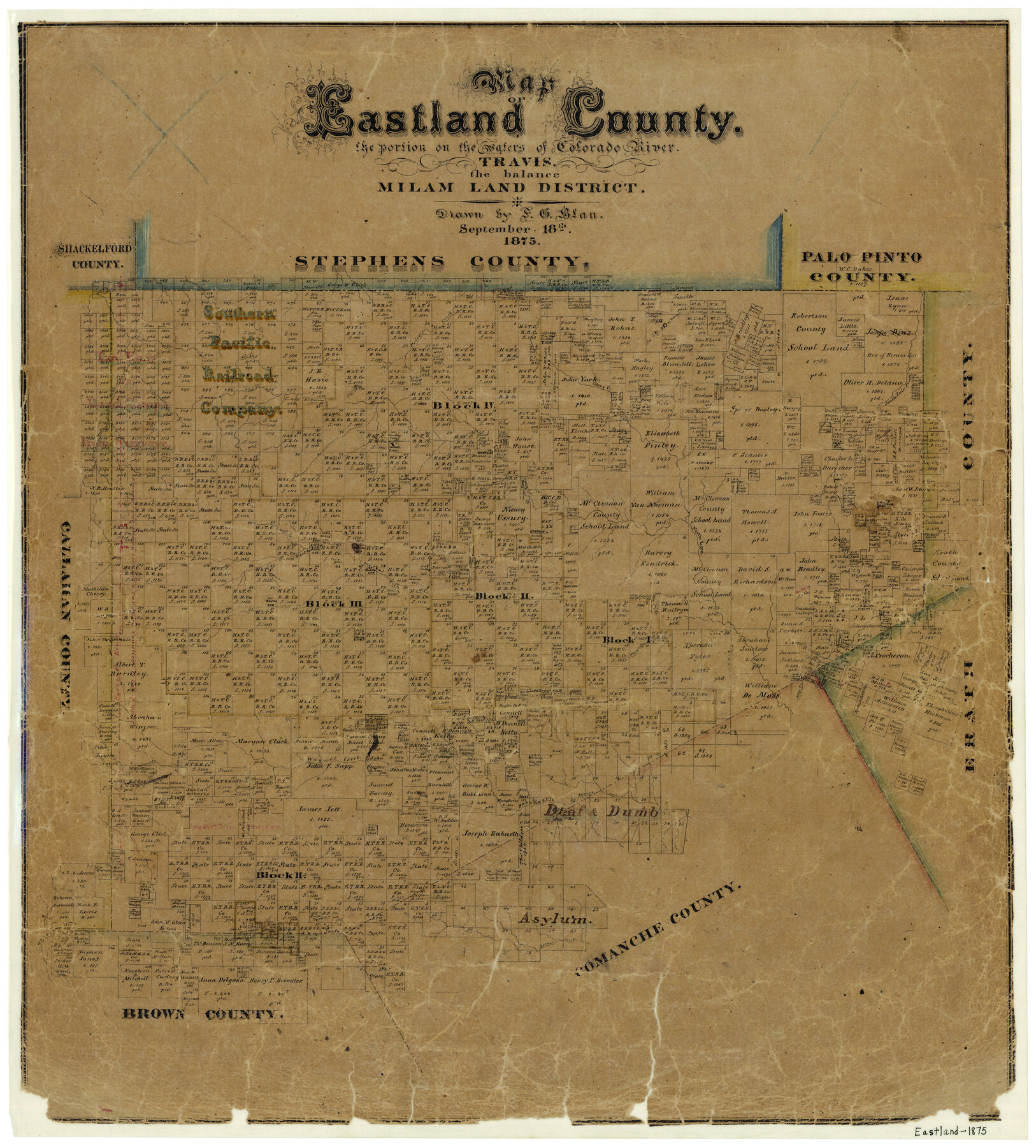
Map of Eastland County, the portion on the waters of Colorado River Travis the balance- Milam- Land District
-
Map/Doc
3500
-
Collection
General Map Collection
-
Object Dates
9/18/1875 (Creation Date)
-
People and Organizations
Texas General Land Office (Publisher)
F.G. Blau (Draftsman)
-
Counties
Eastland
-
Subjects
County
-
Height x Width
24.6 x 22.2 inches
62.5 x 56.4 cm
-
Features
Bush Creek
East Fork of Hubbard's Creek
Fish Creek
Price's Creek
Colony Creek
South Palo Pinto Creek
North Leon River
Coal Creek
Nash's Creek
Hog Creek
Wayne's Creek
Sabana Creek
Red Haw Creek
Eastland
Part of: General Map Collection
Nolan County Working Sketch 7

Print $20.00
- Digital $50.00
Nolan County Working Sketch 7
1954
Size 33.9 x 24.3 inches
Map/Doc 71298
Kenedy County Aerial Photograph Index Sheet 5

Print $20.00
- Digital $50.00
Kenedy County Aerial Photograph Index Sheet 5
1943
Size 23.5 x 19.6 inches
Map/Doc 89046
Menard County Working Sketch 28

Print $20.00
- Digital $50.00
Menard County Working Sketch 28
1963
Size 24.3 x 37.7 inches
Map/Doc 70975
Motley County Sketch File 28 (S)

Print $4.00
- Digital $50.00
Motley County Sketch File 28 (S)
Size 8.8 x 7.9 inches
Map/Doc 32211
[San Antonio & Galveston RR]
![64149, [San Antonio & Galveston RR], General Map Collection](https://historictexasmaps.com/wmedia_w700/maps/64149.tif.jpg)
Print $20.00
- Digital $50.00
[San Antonio & Galveston RR]
Size 37.6 x 11.2 inches
Map/Doc 64149
Orange County Boundary File 7

Print $10.00
- Digital $50.00
Orange County Boundary File 7
Size 4.1 x 7.6 inches
Map/Doc 57775
Austin County Sketch File 13

Print $40.00
- Digital $50.00
Austin County Sketch File 13
Size 13.9 x 13.2 inches
Map/Doc 10877
Mississippi River to Galveston

Print $40.00
- Digital $50.00
Mississippi River to Galveston
1973
Size 37.2 x 51.2 inches
Map/Doc 69946
Duval County Working Sketch 2

Print $20.00
- Digital $50.00
Duval County Working Sketch 2
1919
Size 16.4 x 15.0 inches
Map/Doc 76443
Railroad Track Map, H&TCRRCo., Falls County, Texas

Print $4.00
- Digital $50.00
Railroad Track Map, H&TCRRCo., Falls County, Texas
1918
Size 11.3 x 18.5 inches
Map/Doc 62847
Hudspeth County Rolled Sketch 17

Print $40.00
- Digital $50.00
Hudspeth County Rolled Sketch 17
1886
Size 22.3 x 118.5 inches
Map/Doc 9203
Carta Orografica

Print $20.00
- Digital $50.00
Carta Orografica
Size 26.0 x 34.4 inches
Map/Doc 96802
You may also like
Northeast Part of Crockett County

Print $20.00
- Digital $50.00
Northeast Part of Crockett County
1976
Size 35.6 x 46.1 inches
Map/Doc 73120
Rusk County Working Sketch 7

Print $20.00
- Digital $50.00
Rusk County Working Sketch 7
1982
Size 22.3 x 36.7 inches
Map/Doc 63642
Flight Mission No. CRE-2R, Frame 80, Jackson County

Print $20.00
- Digital $50.00
Flight Mission No. CRE-2R, Frame 80, Jackson County
1956
Size 18.7 x 22.3 inches
Map/Doc 85352
Jackson County Sketch File 3

Print $34.00
- Digital $50.00
Jackson County Sketch File 3
1875
Size 7.9 x 7.7 inches
Map/Doc 27621
Kendall County Sketch File 9

Print $6.00
- Digital $50.00
Kendall County Sketch File 9
1879
Size 4.6 x 9.3 inches
Map/Doc 28692
Colorado River, Shoal Creek from 12th to 34th Street/Austin, Texas

Print $40.00
- Digital $50.00
Colorado River, Shoal Creek from 12th to 34th Street/Austin, Texas
1929
Size 61.5 x 28.6 inches
Map/Doc 65327
Nueces County Rolled Sketch 136

Print $40.00
- Digital $50.00
Nueces County Rolled Sketch 136
2006
Size 37.5 x 50.0 inches
Map/Doc 83556
Flight Mission No. CGN-3P, Frame 53, San Patricio County

Print $20.00
- Digital $50.00
Flight Mission No. CGN-3P, Frame 53, San Patricio County
1956
Size 18.6 x 22.3 inches
Map/Doc 86983
Township No. 1 South Range No. 25 West of the Indian Meridian

Print $20.00
- Digital $50.00
Township No. 1 South Range No. 25 West of the Indian Meridian
1875
Size 19.2 x 24.3 inches
Map/Doc 75248
Titus County Sketch File 1

Print $4.00
- Digital $50.00
Titus County Sketch File 1
Size 13.3 x 8.2 inches
Map/Doc 38130
Flight Mission No. CRC-4R, Frame 92, Chambers County

Print $20.00
- Digital $50.00
Flight Mission No. CRC-4R, Frame 92, Chambers County
1956
Size 18.5 x 22.4 inches
Map/Doc 84889
Isogonic Chart for 1950, United States. Including Isoporic Lines

Print $20.00
- Digital $50.00
Isogonic Chart for 1950, United States. Including Isoporic Lines
1950
Size 32.2 x 47.2 inches
Map/Doc 75921