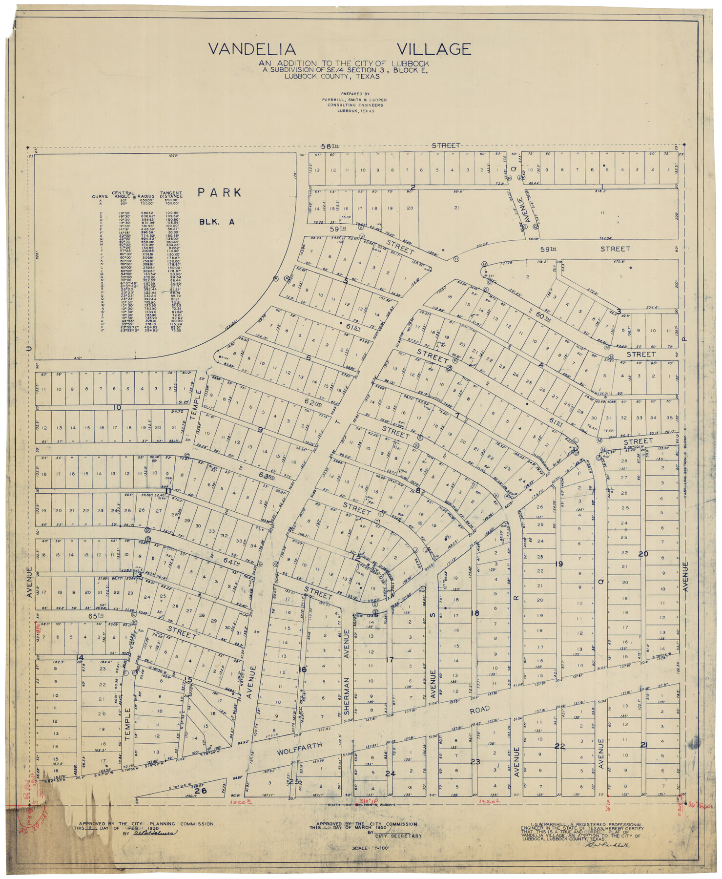
Vandelia Village an Addition to the City of Lubbock, a Subdivision of Southeast Quarter, Section 3, Block E
-
Map/Doc
92725
-
Collection
Twichell Survey Records
-
Object Dates
2/9/1950 (Creation Date)
-
People and Organizations
Parkhill, Smith and Cooper (Draftsman)
G.W. Parkhill (Surveyor/Engineer)
-
Counties
Lubbock
-
Height x Width
29.6 x 36.0 inches
75.2 x 91.4 cm
Part of: Twichell Survey Records
[Area along West County Line]
![90832, [Area along West County Line], Twichell Survey Records](https://historictexasmaps.com/wmedia_w700/maps/90832-2.tif.jpg)
Print $2.00
- Digital $50.00
[Area along West County Line]
Size 6.0 x 9.6 inches
Map/Doc 90832
[Stone, Kyle and Kyle Block M6]
![90392, [Stone, Kyle and Kyle Block M6], Twichell Survey Records](https://historictexasmaps.com/wmedia_w700/maps/90392-1.tif.jpg)
Print $3.00
- Digital $50.00
[Stone, Kyle and Kyle Block M6]
Size 11.9 x 15.2 inches
Map/Doc 90392
[Sketch of Railroad Switchyard stretching from Ross to Monroe Streets, Amarillo, Texas]
![91830, [Sketch of Railroad Switchyard stretching from Ross to Monroe Streets, Amarillo, Texas], Twichell Survey Records](https://historictexasmaps.com/wmedia_w700/maps/91830-1.tif.jpg)
Print $20.00
- Digital $50.00
[Sketch of Railroad Switchyard stretching from Ross to Monroe Streets, Amarillo, Texas]
Size 10.0 x 36.1 inches
Map/Doc 91830
[Map of Resurvey of Block 34 and 35, Township 5 N]
![90551, [Map of Resurvey of Block 34 and 35, Township 5 N], Twichell Survey Records](https://historictexasmaps.com/wmedia_w700/maps/90551-1.tif.jpg)
Print $20.00
- Digital $50.00
[Map of Resurvey of Block 34 and 35, Township 5 N]
1915
Size 25.5 x 16.4 inches
Map/Doc 90551
St Francis situated in Potter and Carson Counties, Texas

Print $20.00
- Digital $50.00
St Francis situated in Potter and Carson Counties, Texas
Size 21.8 x 28.0 inches
Map/Doc 93083
[East County Line]
![90225, [East County Line], Twichell Survey Records](https://historictexasmaps.com/wmedia_w700/maps/90225-1.tif.jpg)
Print $20.00
- Digital $50.00
[East County Line]
Size 38.2 x 11.7 inches
Map/Doc 90225
[Area between H. & T. C. Block 34, PSL Block B19 and University Lands Block 16]
![91957, [Area between H. & T. C. Block 34, PSL Block B19 and University Lands Block 16], Twichell Survey Records](https://historictexasmaps.com/wmedia_w700/maps/91957-1.tif.jpg)
Print $20.00
- Digital $50.00
[Area between H. & T. C. Block 34, PSL Block B19 and University Lands Block 16]
1929
Size 40.4 x 29.3 inches
Map/Doc 91957
Magnetic Declination in the United States - Epoch 1980

Print $20.00
- Digital $50.00
Magnetic Declination in the United States - Epoch 1980
1980
Size 41.4 x 33.3 inches
Map/Doc 92368
Part of west line of Dawson County rough sketch from surveyor's blueprint

Print $20.00
- Digital $50.00
Part of west line of Dawson County rough sketch from surveyor's blueprint
1915
Size 14.0 x 20.2 inches
Map/Doc 90628
Potter County Sketch

Print $20.00
- Digital $50.00
Potter County Sketch
Size 16.3 x 20.9 inches
Map/Doc 91808
[Section 114, Block Z2]
![90371, [Section 114, Block Z2], Twichell Survey Records](https://historictexasmaps.com/wmedia_w700/maps/90371-1.tif.jpg)
Print $2.00
- Digital $50.00
[Section 114, Block Z2]
1907
Size 8.9 x 10.1 inches
Map/Doc 90371
[Blocks N and B]
![90498, [Blocks N and B], Twichell Survey Records](https://historictexasmaps.com/wmedia_w700/maps/90498-1.tif.jpg)
Print $3.00
- Digital $50.00
[Blocks N and B]
Size 10.0 x 11.4 inches
Map/Doc 90498
You may also like
Oldham County Boundary File 1d

Print $68.00
- Digital $50.00
Oldham County Boundary File 1d
Size 14.0 x 8.5 inches
Map/Doc 57759
Harris County NRC Article 33.136 Sketch 2

Print $30.00
- Digital $50.00
Harris County NRC Article 33.136 Sketch 2
2000
Size 30.6 x 42.2 inches
Map/Doc 61596
Nueces County Rolled Sketch 113B

Print $20.00
- Digital $50.00
Nueces County Rolled Sketch 113B
1972
Size 18.6 x 24.2 inches
Map/Doc 7123
Hansford County, Texas

Print $20.00
- Digital $50.00
Hansford County, Texas
1888
Size 22.6 x 18.6 inches
Map/Doc 5033
King County Rolled Sketch 8

Print $20.00
- Digital $50.00
King County Rolled Sketch 8
1902
Size 34.8 x 29.8 inches
Map/Doc 6531
Coryell County Rolled Sketch 1

Print $20.00
- Digital $50.00
Coryell County Rolled Sketch 1
1943
Size 22.7 x 21.4 inches
Map/Doc 5565
L'Amerique Meridionale et Septentrionale

Print $20.00
- Digital $50.00
L'Amerique Meridionale et Septentrionale
1731
Size 20.0 x 28.3 inches
Map/Doc 93825
Flight Mission No. DQO-6K, Frame 21, Galveston County

Print $20.00
- Digital $50.00
Flight Mission No. DQO-6K, Frame 21, Galveston County
1952
Size 18.7 x 22.3 inches
Map/Doc 85094
Sketch Showing Lands Conveyed to Texas State Park Board by the City of Lubbock, Texas for the Location of MacKenzie State Park

Print $20.00
- Digital $50.00
Sketch Showing Lands Conveyed to Texas State Park Board by the City of Lubbock, Texas for the Location of MacKenzie State Park
1935
Size 26.4 x 33.1 inches
Map/Doc 92724
Plan of the City of Indianola, Texas

Print $40.00
- Digital $50.00
Plan of the City of Indianola, Texas
1868
Size 37.5 x 55.3 inches
Map/Doc 4835

Flight Mission No. BRA-16M, Frame 60, Jefferson County

Print $20.00
- Digital $50.00
Flight Mission No. BRA-16M, Frame 60, Jefferson County
1953
Size 18.6 x 22.3 inches
Map/Doc 85677