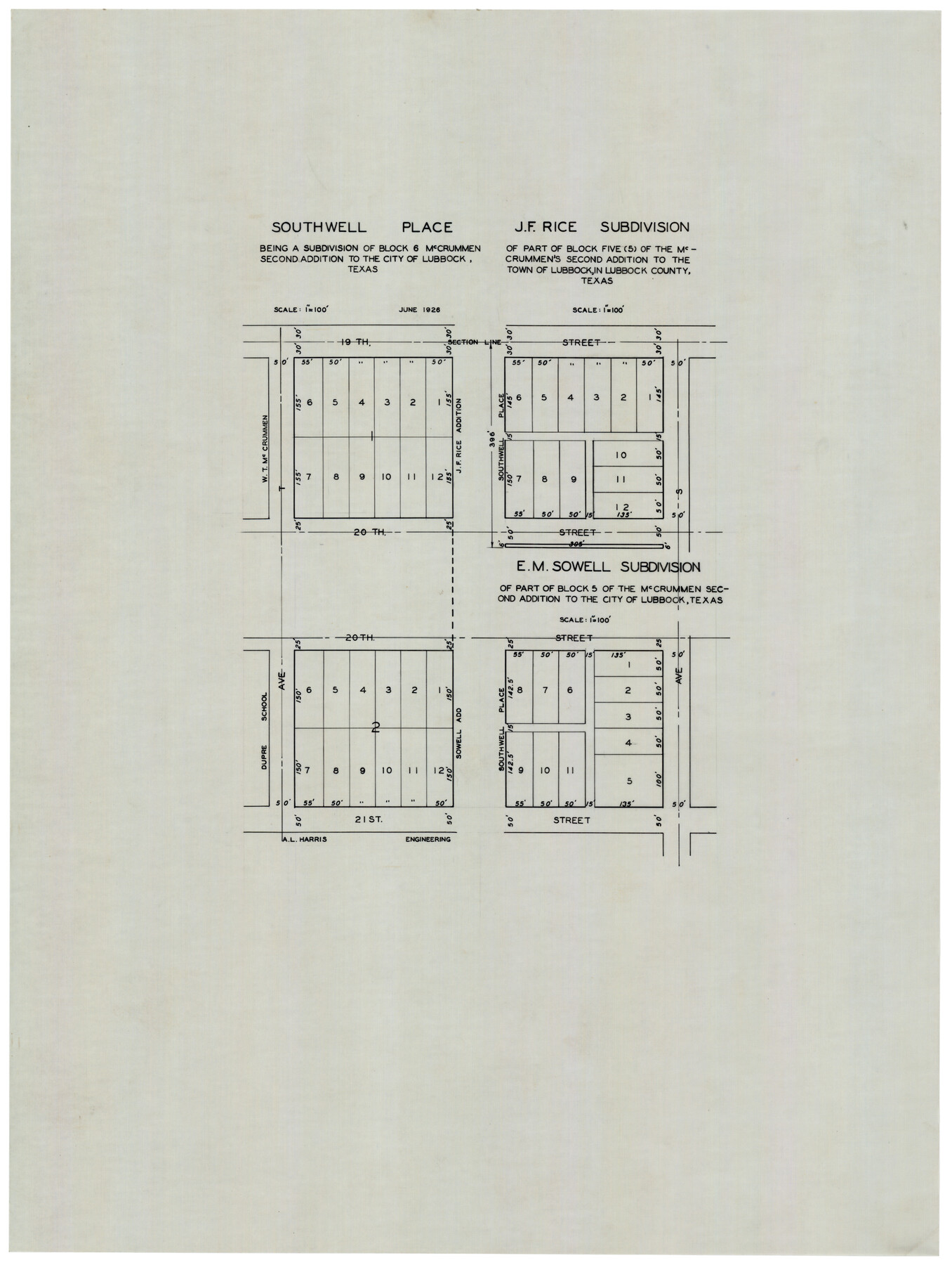
Southwell Place and J. F. Rice Subdivision
-
Map/Doc
92745
-
Collection
Twichell Survey Records
-
Object Dates
6/1926 (Creation Date)
-
Counties
Lubbock
-
Height x Width
19.1 x 24.8 inches
48.5 x 63.0 cm
Part of: Twichell Survey Records
[S. M. Walker, D. P. Allen, J. C. Guinn, J. R. Lamar and surrounding surveys]
![90335, [S. M. Walker, D. P. Allen, J. C. Guinn, J. R. Lamar and surrounding surveys], Twichell Survey Records](https://historictexasmaps.com/wmedia_w700/maps/90335-1.tif.jpg)
Print $3.00
- Digital $50.00
[S. M. Walker, D. P. Allen, J. C. Guinn, J. R. Lamar and surrounding surveys]
1912
Size 9.8 x 11.3 inches
Map/Doc 90335
[Capitol Leagues 294, 295, 301, 302, 303, and 304]
![91422, [Capitol Leagues 294, 295, 301, 302, 303, and 304], Twichell Survey Records](https://historictexasmaps.com/wmedia_w700/maps/91422-1.tif.jpg)
Print $20.00
- Digital $50.00
[Capitol Leagues 294, 295, 301, 302, 303, and 304]
1883
Size 16.1 x 12.5 inches
Map/Doc 91422
Lgs. 276 thru 280-289, 333, 336, 345, 355 thru 357, 367, Blk. K11

Print $20.00
- Digital $50.00
Lgs. 276 thru 280-289, 333, 336, 345, 355 thru 357, 367, Blk. K11
Size 28.0 x 12.3 inches
Map/Doc 91429
[T. & P. Blocks 43-45, Townships 1S and 1N]
![90878, [T. & P. Blocks 43-45, Townships 1S and 1N], Twichell Survey Records](https://historictexasmaps.com/wmedia_w700/maps/90878-2.tif.jpg)
Print $20.00
- Digital $50.00
[T. & P. Blocks 43-45, Townships 1S and 1N]
Size 22.9 x 18.0 inches
Map/Doc 90878
[G. & M. Block O, M. B. & A. Block N, PSL Blocks B-19 and B-29 showing alleged vacancy]
![89812, [G. & M. Block O, M. B. & A. Block N, PSL Blocks B-19 and B-29 showing alleged vacancy], Twichell Survey Records](https://historictexasmaps.com/wmedia_w700/maps/89812-1.tif.jpg)
Print $40.00
- Digital $50.00
[G. & M. Block O, M. B. & A. Block N, PSL Blocks B-19 and B-29 showing alleged vacancy]
Size 72.2 x 36.9 inches
Map/Doc 89812
![91463, [Block B7], Twichell Survey Records](https://historictexasmaps.com/wmedia_w700/maps/91463-1.tif.jpg)
[Blocks 71 and C-8]
![91778, [Blocks 71 and C-8], Twichell Survey Records](https://historictexasmaps.com/wmedia_w700/maps/91778-1.tif.jpg)
Print $20.00
- Digital $50.00
[Blocks 71 and C-8]
Size 29.7 x 21.1 inches
Map/Doc 91778
[Texas and New Orleans Railroad Company, Block 2]
![92702, [Texas and New Orleans Railroad Company, Block 2], Twichell Survey Records](https://historictexasmaps.com/wmedia_w700/maps/92702-1.tif.jpg)
Print $20.00
- Digital $50.00
[Texas and New Orleans Railroad Company, Block 2]
1906
Size 21.1 x 14.4 inches
Map/Doc 92702
Map Showing Lands Surveyed by Sylvan Sanders, Block D

Print $20.00
- Digital $50.00
Map Showing Lands Surveyed by Sylvan Sanders, Block D
Size 28.2 x 23.5 inches
Map/Doc 92440

Lubbock County Hale County

Print $20.00
- Digital $50.00
Lubbock County Hale County
Size 18.0 x 22.4 inches
Map/Doc 92833
[Sketch showing the Northwest part of Hale County and the Northeast part of Lamb County]
![93205, [Sketch showing the Northwest part of Hale County and the Northeast part of Lamb County], Twichell Survey Records](https://historictexasmaps.com/wmedia_w700/maps/93205-1.tif.jpg)
Print $40.00
- Digital $50.00
[Sketch showing the Northwest part of Hale County and the Northeast part of Lamb County]
Size 55.3 x 56.7 inches
Map/Doc 93205
You may also like
Flight Mission No. BRA-7M, Frame 14, Jefferson County

Print $20.00
- Digital $50.00
Flight Mission No. BRA-7M, Frame 14, Jefferson County
1953
Size 18.6 x 22.3 inches
Map/Doc 85465
Flight Mission No. CRK-3P, Frame 68, Refugio County

Print $20.00
- Digital $50.00
Flight Mission No. CRK-3P, Frame 68, Refugio County
1956
Size 18.7 x 22.5 inches
Map/Doc 86910
Layout of the porciones as described in the Visita General of Laredo, 1767

Layout of the porciones as described in the Visita General of Laredo, 1767
2009
Size 11.0 x 8.5 inches
Map/Doc 94042
Kendall County Working Sketch 27

Print $20.00
- Digital $50.00
Kendall County Working Sketch 27
1994
Size 25.0 x 37.5 inches
Map/Doc 66700
[Cotton Belt, St. Louis Southwestern Railway of Texas, Alignment through Smith County]
![64374, [Cotton Belt, St. Louis Southwestern Railway of Texas, Alignment through Smith County], General Map Collection](https://historictexasmaps.com/wmedia_w700/maps/64374.tif.jpg)
Print $20.00
- Digital $50.00
[Cotton Belt, St. Louis Southwestern Railway of Texas, Alignment through Smith County]
1903
Size 21.5 x 29.3 inches
Map/Doc 64374
Glasscock County

Print $20.00
- Digital $50.00
Glasscock County
1933
Size 41.1 x 34.7 inches
Map/Doc 77290
The Republic County of Gonzales. May 24, 1838

Print $20.00
The Republic County of Gonzales. May 24, 1838
2020
Size 14.7 x 21.7 inches
Map/Doc 96156
Hansford County Working Sketch 5

Print $20.00
- Digital $50.00
Hansford County Working Sketch 5
1967
Size 30.2 x 28.3 inches
Map/Doc 63377
Deaf Smith County Sketch File 5

Print $9.00
- Digital $50.00
Deaf Smith County Sketch File 5
1905
Size 11.3 x 8.9 inches
Map/Doc 20648
[Map of Grayson County]
![4551, [Map of Grayson County], General Map Collection](https://historictexasmaps.com/wmedia_w700/maps/4551-1.tif.jpg)
Print $20.00
- Digital $50.00
[Map of Grayson County]
1848
Size 25.6 x 20.0 inches
Map/Doc 4551
Vacancy Application - John H. Tyler near T.C. Ry. Co. Block 1 Surveys 101, 102, 103, & 104. Letters and Maps, Pecos County

Print $279.00
- Digital $50.00
Vacancy Application - John H. Tyler near T.C. Ry. Co. Block 1 Surveys 101, 102, 103, & 104. Letters and Maps, Pecos County
1934
Size 18.1 x 21.1 inches
Map/Doc 2048
General Highway Map, Ellis County, Texas

Print $20.00
General Highway Map, Ellis County, Texas
1961
Size 18.2 x 24.6 inches
Map/Doc 79453