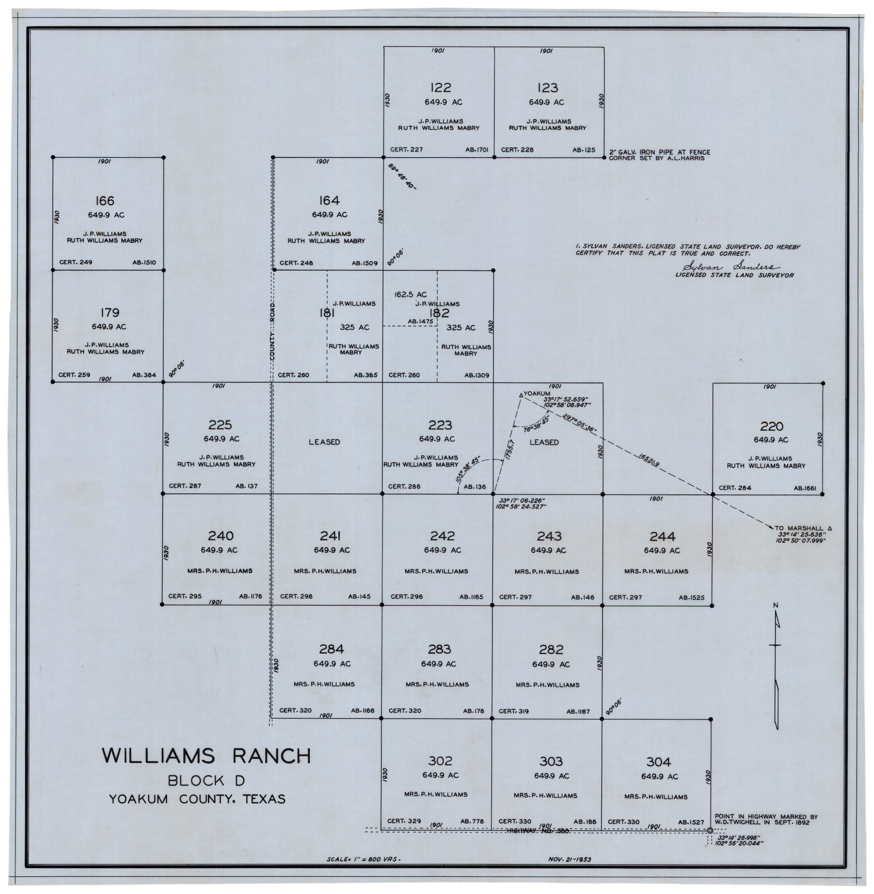
Williams Ranch Block D
-
Map/Doc
92850
-
Collection
Twichell Survey Records
-
Object Dates
11/21/1953 (Creation Date)
-
People and Organizations
Sylvan Sanders (Surveyor/Engineer)
-
Counties
Yoakum
-
Height x Width
19.3 x 19.6 inches
49.0 x 49.8 cm
Part of: Twichell Survey Records
[Blocks 47, Z, XO2, M18, M23, M25, and H]
![91186, [Blocks 47, Z, XO2, M18, M23, M25, and H], Twichell Survey Records](https://historictexasmaps.com/wmedia_w700/maps/91186-1.tif.jpg)
Print $20.00
- Digital $50.00
[Blocks 47, Z, XO2, M18, M23, M25, and H]
Size 30.1 x 23.5 inches
Map/Doc 91186
[Sketch between Wheeler County and Oklahoma]
![89674, [Sketch between Wheeler County and Oklahoma], Twichell Survey Records](https://historictexasmaps.com/wmedia_w700/maps/89674-1.tif.jpg)
Print $40.00
- Digital $50.00
[Sketch between Wheeler County and Oklahoma]
Size 64.9 x 10.2 inches
Map/Doc 89674
Leagues 218, 220, 238- 241, 226- 229]
![91066, Leagues 218, 220, 238- 241, 226- 229], Twichell Survey Records](https://historictexasmaps.com/wmedia_w700/maps/91066-1.tif.jpg)
Print $20.00
- Digital $50.00
Leagues 218, 220, 238- 241, 226- 229]
Size 10.3 x 33.7 inches
Map/Doc 91066
[Sketch showing part of Blk. M6]
![89642, [Sketch showing part of Blk. M6], Twichell Survey Records](https://historictexasmaps.com/wmedia_w700/maps/89642-1.tif.jpg)
Print $40.00
- Digital $50.00
[Sketch showing part of Blk. M6]
1913
Size 64.8 x 30.3 inches
Map/Doc 89642
Amended Plat New Hobbs Addition to New Hobbs, Lea County, New Mexico

Print $20.00
- Digital $50.00
Amended Plat New Hobbs Addition to New Hobbs, Lea County, New Mexico
Size 24.1 x 18.5 inches
Map/Doc 92418
[Randall County School Land League 152 and vicinity]
![92998, [Randall County School Land League 152 and vicinity], Twichell Survey Records](https://historictexasmaps.com/wmedia_w700/maps/92998.tif.jpg)
Print $3.00
- Digital $50.00
[Randall County School Land League 152 and vicinity]
1949
Size 15.0 x 10.9 inches
Map/Doc 92998
[King, Knox & Stonewall Counties]
![92917, [King, Knox & Stonewall Counties], Twichell Survey Records](https://historictexasmaps.com/wmedia_w700/maps/92917-1.tif.jpg)
Print $20.00
- Digital $50.00
[King, Knox & Stonewall Counties]
1902
Size 19.6 x 28.2 inches
Map/Doc 92917
[Blocks T1, T2, T3, and Vicinity]
![90982, [Blocks T1, T2, T3, and Vicinity], Twichell Survey Records](https://historictexasmaps.com/wmedia_w700/maps/90982-1.tif.jpg)
Print $20.00
- Digital $50.00
[Blocks T1, T2, T3, and Vicinity]
Size 30.6 x 32.7 inches
Map/Doc 90982
[H. & G. N. Block 1]
![90939, [H. & G. N. Block 1], Twichell Survey Records](https://historictexasmaps.com/wmedia_w700/maps/90939-1.tif.jpg)
Print $20.00
- Digital $50.00
[H. & G. N. Block 1]
1902
Size 13.5 x 16.4 inches
Map/Doc 90939
[H. & T. C. Block 47 and part of G. & M. Block 3]
![91817, [H. & T. C. Block 47 and part of G. & M. Block 3], Twichell Survey Records](https://historictexasmaps.com/wmedia_w700/maps/91817-1.tif.jpg)
Print $20.00
- Digital $50.00
[H. & T. C. Block 47 and part of G. & M. Block 3]
Size 29.4 x 27.9 inches
Map/Doc 91817
[Northeast Portion of Moore County]
![91517, [Northeast Portion of Moore County], Twichell Survey Records](https://historictexasmaps.com/wmedia_w700/maps/91517-1.tif.jpg)
Print $20.00
- Digital $50.00
[Northeast Portion of Moore County]
Size 31.7 x 8.5 inches
Map/Doc 91517
Southwell Place and J. F. Rice Subdivision

Print $20.00
- Digital $50.00
Southwell Place and J. F. Rice Subdivision
1926
Size 19.1 x 24.8 inches
Map/Doc 92745
You may also like
2017 Official Travel Map, Texas

2017 Official Travel Map, Texas
2017
Size 33.5 x 36.4 inches
Map/Doc 94414
Map Exhibiting the Leading Transportation Lines of the Pacific Coast, prepared for the report of the Chief of the Bureau of Statistics on the internal commerce of the United States

Print $20.00
- Digital $50.00
Map Exhibiting the Leading Transportation Lines of the Pacific Coast, prepared for the report of the Chief of the Bureau of Statistics on the internal commerce of the United States
1887
Size 22.2 x 24.5 inches
Map/Doc 95905
Clayton Carter Addition, North 84.9 Acres of Section 77, Block A

Print $20.00
- Digital $50.00
Clayton Carter Addition, North 84.9 Acres of Section 77, Block A
1945
Size 30.1 x 9.6 inches
Map/Doc 92767
Brewster County Sketch File 50

Print $32.00
- Digital $50.00
Brewster County Sketch File 50
1995
Size 14.8 x 8.5 inches
Map/Doc 16336
[Surveys in the Travis District along the Colorado and Pedernales Rivers]
![113, [Surveys in the Travis District along the Colorado and Pedernales Rivers], General Map Collection](https://historictexasmaps.com/wmedia_w700/maps/113.tif.jpg)
Print $2.00
- Digital $50.00
[Surveys in the Travis District along the Colorado and Pedernales Rivers]
1841
Size 9.9 x 8.2 inches
Map/Doc 113
Plat showing proposed counties to be taken from Zapata, Starr & Hidalgo Counties

Print $20.00
- Digital $50.00
Plat showing proposed counties to be taken from Zapata, Starr & Hidalgo Counties
1911
Size 24.8 x 27.8 inches
Map/Doc 2660
Duval County Sketch File 54

Print $20.00
- Digital $50.00
Duval County Sketch File 54
1937
Size 19.0 x 26.4 inches
Map/Doc 11403


Atascosa County Working Sketch 32

Print $20.00
- Digital $50.00
Atascosa County Working Sketch 32
1981
Size 12.9 x 11.8 inches
Map/Doc 67228
San Jacinto River, Buff Lake Sheet 2/Caney Creek

Print $4.00
- Digital $50.00
San Jacinto River, Buff Lake Sheet 2/Caney Creek
1937
Size 24.1 x 24.7 inches
Map/Doc 65148
Liberty County Working Sketch 62

Print $20.00
- Digital $50.00
Liberty County Working Sketch 62
1969
Size 22.1 x 28.3 inches
Map/Doc 70522