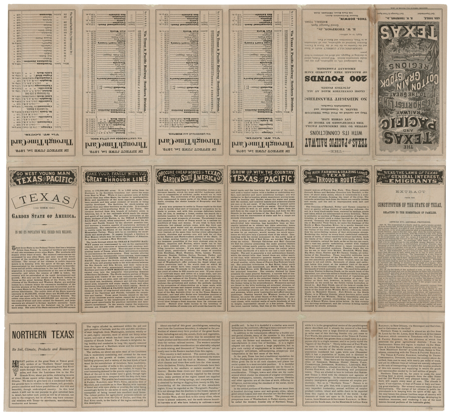
A Geographically Correct Map of the State of Texas
[verso]
-
Map/Doc
93398
-
Collection
General Map Collection
-
Object Dates
1876 (Creation Date)
-
People and Organizations
Texas and Pacific Railway Company (Publisher)
Woodward, Tiernan and Hale (Printer)
-
Subjects
State of Texas
-
Height x Width
20.0 x 21.5 inches
50.8 x 54.6 cm
-
Medium
paper, etching/engraving/lithograph
-
Comments
See 93397 for map on reverse.
Related maps
A Geographically Correct Map of the State of Texas

Print $20.00
- Digital $50.00
A Geographically Correct Map of the State of Texas
1876
Size 20.0 x 21.5 inches
Map/Doc 93397
Part of: General Map Collection
Edwards County Working Sketch 81

Print $40.00
- Digital $50.00
Edwards County Working Sketch 81
1964
Size 61.4 x 39.6 inches
Map/Doc 68957
Bandera County Working Sketch 44

Print $20.00
- Digital $50.00
Bandera County Working Sketch 44
1980
Size 14.0 x 20.4 inches
Map/Doc 67640
Map of Zapata County

Print $20.00
- Digital $50.00
Map of Zapata County
1880
Size 27.1 x 25.7 inches
Map/Doc 4177
Walker County Working Sketch 17

Print $20.00
- Digital $50.00
Walker County Working Sketch 17
Size 19.9 x 20.8 inches
Map/Doc 72297
Montgomery County Working Sketch 49

Print $20.00
- Digital $50.00
Montgomery County Working Sketch 49
1959
Size 13.8 x 12.0 inches
Map/Doc 71156
Jack County Sketch File 18c

Print $60.00
- Digital $50.00
Jack County Sketch File 18c
Size 20.0 x 30.7 inches
Map/Doc 11828
Kaufman County Sketch File A

Print $4.00
- Digital $50.00
Kaufman County Sketch File A
1879
Size 14.1 x 8.8 inches
Map/Doc 28630
Archer County Working Sketch 4

Print $40.00
- Digital $50.00
Archer County Working Sketch 4
1918
Size 49.9 x 68.3 inches
Map/Doc 67144
Ochiltree County Sketch File 8

Print $16.00
- Digital $50.00
Ochiltree County Sketch File 8
1933
Size 11.2 x 8.7 inches
Map/Doc 33186
Val Verde County Sketch File Z9

Print $20.00
- Digital $50.00
Val Verde County Sketch File Z9
1891
Size 15.9 x 24.8 inches
Map/Doc 12554
Crane County Working Sketch 21

Print $20.00
- Digital $50.00
Crane County Working Sketch 21
1961
Size 34.5 x 37.1 inches
Map/Doc 68298
Kimble County Working Sketch 5

Print $20.00
- Digital $50.00
Kimble County Working Sketch 5
1915
Size 17.0 x 13.4 inches
Map/Doc 70073
You may also like
The Republic County of Refugio. Proposed, Late Fall 1837

Print $20.00
The Republic County of Refugio. Proposed, Late Fall 1837
2020
Size 22.3 x 21.6 inches
Map/Doc 96256
Webb County Sketch File 71

Print $44.00
- Digital $50.00
Webb County Sketch File 71
Size 14.4 x 7.6 inches
Map/Doc 39888
Sutton County Rolled Sketch 49
Print $20.00
- Digital $50.00
Sutton County Rolled Sketch 49
Size 19.2 x 19.3 inches
Map/Doc 7890
Sutton County Working Sketch 18

Print $20.00
- Digital $50.00
Sutton County Working Sketch 18
Size 39.9 x 31.5 inches
Map/Doc 62361
General Highway Map, Mills County, Texas

Print $20.00
General Highway Map, Mills County, Texas
1940
Size 18.4 x 24.8 inches
Map/Doc 79199
Flight Mission No. DQN-4K, Frame 6, Calhoun County

Print $20.00
- Digital $50.00
Flight Mission No. DQN-4K, Frame 6, Calhoun County
1953
Size 18.6 x 22.4 inches
Map/Doc 84371
Map of Galveston West Bay and Part of Galveston Island

Print $40.00
- Digital $50.00
Map of Galveston West Bay and Part of Galveston Island
1851
Size 31.2 x 52.6 inches
Map/Doc 69923
Texas-Indian Territory Gainesville Quadrangle

Print $20.00
- Digital $50.00
Texas-Indian Territory Gainesville Quadrangle
1902
Size 20.4 x 16.9 inches
Map/Doc 75102
Kent County Working Sketch 19

Print $40.00
- Digital $50.00
Kent County Working Sketch 19
1980
Size 36.8 x 51.5 inches
Map/Doc 70026
Flight Mission No. BQR-5K, Frame 65, Brazoria County

Print $20.00
- Digital $50.00
Flight Mission No. BQR-5K, Frame 65, Brazoria County
1952
Size 18.8 x 22.5 inches
Map/Doc 84010
Washington County Texas

Print $20.00
- Digital $50.00
Washington County Texas
1879
Size 13.2 x 21.3 inches
Map/Doc 4124
Sketch T [showing Capitol Reserve]
![89631, Sketch T [showing Capitol Reserve], Twichell Survey Records](https://historictexasmaps.com/wmedia_w700/maps/89631-1.tif.jpg)
Print $40.00
- Digital $50.00
Sketch T [showing Capitol Reserve]
1903
Size 22.0 x 48.9 inches
Map/Doc 89631