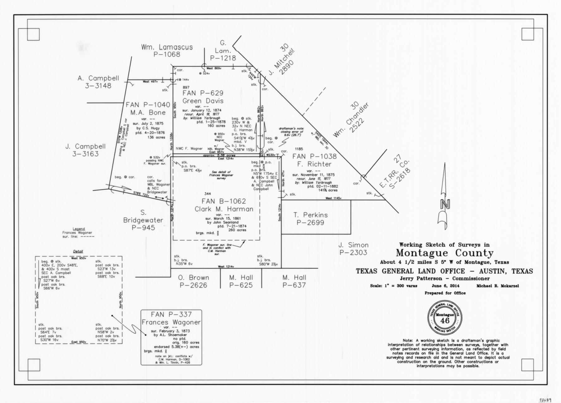
Montague County Working Sketch 46
-
Map/Doc
93689
-
Collection
General Map Collection
-
Object Dates
6/6/2014 (Creation Date)
-
People and Organizations
Jerry E. Patterson (GLO Commissioner)
Michael R. Mokarzel (Draftsman)
-
Counties
Montague
-
Subjects
Surveying Working Sketch
-
Height x Width
14.7 x 20.4 inches
37.3 x 51.8 cm
-
Scale
1" = 300 varas
Part of: General Map Collection
Tarrant County Sketch File 2

Print $4.00
- Digital $50.00
Tarrant County Sketch File 2
1857
Size 7.0 x 6.5 inches
Map/Doc 37674
Montgomery County Working Sketch 2

Print $20.00
- Digital $50.00
Montgomery County Working Sketch 2
1914
Size 14.5 x 23.2 inches
Map/Doc 71108
Briscoe County Rolled Sketch 6

Print $20.00
- Digital $50.00
Briscoe County Rolled Sketch 6
Size 27.0 x 31.4 inches
Map/Doc 5326
Map of the District of San Patricio and Nueces

Print $40.00
- Digital $50.00
Map of the District of San Patricio and Nueces
1847
Size 52.6 x 44.2 inches
Map/Doc 1956
Wood County Sketch File 6

Print $8.00
- Digital $50.00
Wood County Sketch File 6
1877
Size 8.2 x 5.4 inches
Map/Doc 40641
Flight Mission No. DIX-10P, Frame 147, Aransas County

Print $20.00
- Digital $50.00
Flight Mission No. DIX-10P, Frame 147, Aransas County
1956
Size 18.7 x 22.4 inches
Map/Doc 83949
Map of Jasper County Republic of Texas

Print $20.00
- Digital $50.00
Map of Jasper County Republic of Texas
1841
Size 36.1 x 30.0 inches
Map/Doc 3712
Newton County Sketch File 44

Print $8.00
- Digital $50.00
Newton County Sketch File 44
1945
Size 11.2 x 8.6 inches
Map/Doc 32441
Grayson County Sketch File 7

Print $40.00
- Digital $50.00
Grayson County Sketch File 7
1856
Size 12.3 x 12.1 inches
Map/Doc 24470
Sutton County Working Sketch 13

Print $40.00
- Digital $50.00
Sutton County Working Sketch 13
1972
Size 58.8 x 37.0 inches
Map/Doc 62356
Blanco County Sketch File 27

Print $6.00
- Digital $50.00
Blanco County Sketch File 27
1888
Size 14.1 x 11.2 inches
Map/Doc 14621
Austin County

Print $20.00
- Digital $50.00
Austin County
1943
Size 38.5 x 41.3 inches
Map/Doc 77205
You may also like
Upton County Sketch File 10

Print $18.00
- Digital $50.00
Upton County Sketch File 10
1919
Size 13.5 x 8.7 inches
Map/Doc 38839
Ochiltree County

Print $20.00
- Digital $50.00
Ochiltree County
1888
Size 17.3 x 22.6 inches
Map/Doc 91401
Map of Hardeman Co., Texas

Print $20.00
- Digital $50.00
Map of Hardeman Co., Texas
1903
Size 36.8 x 25.6 inches
Map/Doc 4559
Castro County Texas

Print $20.00
- Digital $50.00
Castro County Texas
Size 34.0 x 37.5 inches
Map/Doc 92618
Galveston Co.

Print $40.00
- Digital $50.00
Galveston Co.
1891
Size 38.5 x 53.8 inches
Map/Doc 66834
Wichita County Boundary File 2

Print $30.00
- Digital $50.00
Wichita County Boundary File 2
Size 9.1 x 4.7 inches
Map/Doc 59900
Map of Maryland, Virginia, North Carolina and South Carolina

Print $20.00
- Digital $50.00
Map of Maryland, Virginia, North Carolina and South Carolina
1885
Size 12.2 x 9.0 inches
Map/Doc 93517
Atascosa County Sketch File 3c

Print $4.00
- Digital $50.00
Atascosa County Sketch File 3c
1858
Size 14.3 x 7.3 inches
Map/Doc 13743
[Texas Boundary Line]
![92070, [Texas Boundary Line], Twichell Survey Records](https://historictexasmaps.com/wmedia_w700/maps/92070-1.tif.jpg)
Print $20.00
- Digital $50.00
[Texas Boundary Line]
Size 21.5 x 12.0 inches
Map/Doc 92070
Mason County Working Sketch 19

Print $20.00
- Digital $50.00
Mason County Working Sketch 19
1981
Size 27.0 x 37.1 inches
Map/Doc 70855
McMullen County Sketch File 15

Print $4.00
- Digital $50.00
McMullen County Sketch File 15
1876
Size 10.0 x 8.0 inches
Map/Doc 31363
Culberson County Working Sketch 44

Print $40.00
- Digital $50.00
Culberson County Working Sketch 44
1970
Size 53.4 x 36.4 inches
Map/Doc 68498