Kleberg County Rolled Sketch 10-2
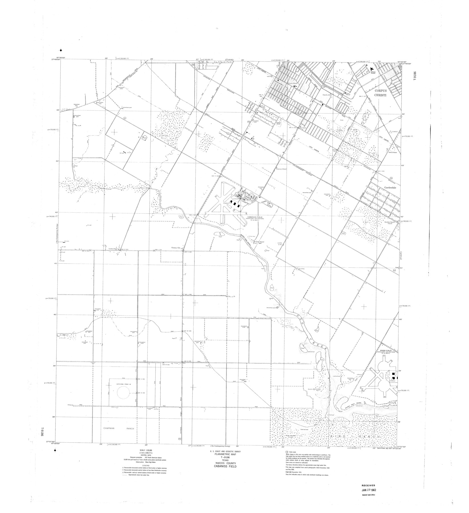
Planimetric Map T-9186, Texas, Nueces County, Cabaniss Field
-
Map/Doc
9377
-
Collection
General Map Collection
-
Object Dates
1951 (Creation Date)
1962/1/29 (File Date)
-
Counties
Nueces
-
Subjects
Surveying Rolled Sketch
-
Height x Width
36.5 x 33.4 inches
92.7 x 84.8 cm
Part of: General Map Collection
Brewster County Rolled Sketch 118

Print $20.00
- Digital $50.00
Brewster County Rolled Sketch 118
1971
Size 25.3 x 37.2 inches
Map/Doc 5295
[Surveys in the Bexar District along the Sabinal River and Rancheros Creek]
![95, [Surveys in the Bexar District along the Sabinal River and Rancheros Creek], General Map Collection](https://historictexasmaps.com/wmedia_w700/maps/95.tif.jpg)
Print $2.00
- Digital $50.00
[Surveys in the Bexar District along the Sabinal River and Rancheros Creek]
1846
Size 8.6 x 7.8 inches
Map/Doc 95
Northwest Part Crockett County

Print $40.00
- Digital $50.00
Northwest Part Crockett County
1983
Size 38.1 x 48.8 inches
Map/Doc 73121
St. Louis, Brownsville & Mexico Railway Location Map from Mile 20 to Mile 40

Print $40.00
- Digital $50.00
St. Louis, Brownsville & Mexico Railway Location Map from Mile 20 to Mile 40
1905
Size 19.2 x 61.4 inches
Map/Doc 64078
Baylor County Sketch File 1

Print $6.00
- Digital $50.00
Baylor County Sketch File 1
Size 17.5 x 11.4 inches
Map/Doc 14117
A Portion of the State's Submerged Oil Field, Goose Creek - Harris County - Texas

Print $20.00
- Digital $50.00
A Portion of the State's Submerged Oil Field, Goose Creek - Harris County - Texas
1919
Size 14.2 x 17.3 inches
Map/Doc 3165
Wharton County Boundary File 1b

Print $20.00
- Digital $50.00
Wharton County Boundary File 1b
Size 15.1 x 26.6 inches
Map/Doc 59855
Dallas County Working Sketch 3

Print $20.00
- Digital $50.00
Dallas County Working Sketch 3
1922
Size 14.2 x 12.2 inches
Map/Doc 68569

Coryell County

Print $20.00
- Digital $50.00
Coryell County
1936
Size 45.4 x 41.4 inches
Map/Doc 95466
Sutton County Sketch File 7

Print $4.00
- Digital $50.00
Sutton County Sketch File 7
Size 10.6 x 8.7 inches
Map/Doc 37365
Mitchell County Working Sketch 3

Print $20.00
- Digital $50.00
Mitchell County Working Sketch 3
1925
Size 30.4 x 33.9 inches
Map/Doc 71060
You may also like
Map of Sutton County

Print $20.00
- Digital $50.00
Map of Sutton County
1887
Size 24.5 x 29.5 inches
Map/Doc 4061
Palo Pinto County Working Sketch 6

Print $20.00
- Digital $50.00
Palo Pinto County Working Sketch 6
1921
Map/Doc 71389
Sutton County Sketch File 27B

Print $20.00
- Digital $50.00
Sutton County Sketch File 27B
Size 19.1 x 14.6 inches
Map/Doc 12384
Padre Island National Seashore, Texas - Dependent Resurvey

Print $4.00
- Digital $50.00
Padre Island National Seashore, Texas - Dependent Resurvey
2001
Size 18.3 x 24.2 inches
Map/Doc 60546
Orange County Sketch File 44

Print $4.00
- Digital $50.00
Orange County Sketch File 44
1895
Size 10.9 x 8.8 inches
Map/Doc 33387

Cooke County Working Sketch 13

Print $20.00
- Digital $50.00
Cooke County Working Sketch 13
1944
Size 29.1 x 38.2 inches
Map/Doc 68250
San Augustine County Rolled Sketch 4

Print $20.00
- Digital $50.00
San Augustine County Rolled Sketch 4
2004
Size 24.5 x 36.7 inches
Map/Doc 83422
Coryell County Sketch File 24

Print $24.00
- Digital $50.00
Coryell County Sketch File 24
1965
Size 11.2 x 8.8 inches
Map/Doc 19389
Bandera County Sketch File 29

Print $40.00
- Digital $50.00
Bandera County Sketch File 29
1939
Size 17.3 x 17.4 inches
Map/Doc 10898
Concho County Rolled Sketch 26

Print $20.00
- Digital $50.00
Concho County Rolled Sketch 26
1979
Size 15.1 x 18.1 inches
Map/Doc 5558
Flight Mission No. CUG-1P, Frame 114, Kleberg County

Print $20.00
- Digital $50.00
Flight Mission No. CUG-1P, Frame 114, Kleberg County
1956
Size 18.5 x 22.1 inches
Map/Doc 86164