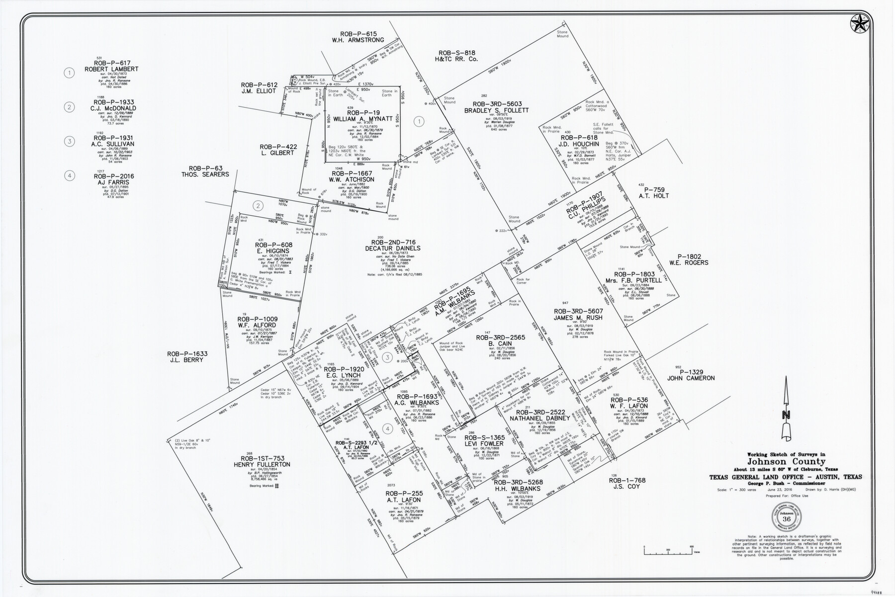
Johnson County Working Sketch 36
-
Map/Doc
94088
-
Collection
General Map Collection
-
Object Dates
6/23/2016 (Creation Date)
-
People and Organizations
David Harris (Draftsman)
-
Counties
Johnson
-
Subjects
Surveying Working Sketch
-
Height x Width
24.1 x 36.1 inches
61.2 x 91.7 cm
-
Medium
mylar, print
-
Scale
1" = 300 varas
Part of: General Map Collection
Proposed bombing and machine gun restricted areas along Gulf of Mexico from San Luis Pass to Aransas Pass

Print $20.00
- Digital $50.00
Proposed bombing and machine gun restricted areas along Gulf of Mexico from San Luis Pass to Aransas Pass
1941
Size 11.1 x 24.1 inches
Map/Doc 3024
McLennan County Sketch File 19

Print $18.00
- Digital $50.00
McLennan County Sketch File 19
1889
Size 12.8 x 7.9 inches
Map/Doc 31284
Dallam County Working Sketch 2

Print $20.00
- Digital $50.00
Dallam County Working Sketch 2
1906
Size 38.5 x 24.1 inches
Map/Doc 68587
Young County Sketch File 17

Print $20.00
- Digital $50.00
Young County Sketch File 17
Size 18.5 x 24.3 inches
Map/Doc 12713
Jefferson County Sketch File 42

Print $20.00
- Digital $50.00
Jefferson County Sketch File 42
1945
Size 25.5 x 35.1 inches
Map/Doc 11876
Nueces County Sketch File 23

Print $36.00
- Digital $50.00
Nueces County Sketch File 23
1886
Size 11.2 x 8.6 inches
Map/Doc 32563
[Maps of surveys in Reeves & Culberson Cos]
![61133, [Maps of surveys in Reeves & Culberson Cos], General Map Collection](https://historictexasmaps.com/wmedia_w700/maps/61133.tif.jpg)
Print $20.00
- Digital $50.00
[Maps of surveys in Reeves & Culberson Cos]
1937
Size 30.7 x 24.8 inches
Map/Doc 61133
Stephens County Sketch File 23

Print $12.00
- Digital $50.00
Stephens County Sketch File 23
1919
Size 11.1 x 8.8 inches
Map/Doc 37084
Flight Mission No. CGI-4N, Frame 190, Cameron County

Print $20.00
- Digital $50.00
Flight Mission No. CGI-4N, Frame 190, Cameron County
1955
Size 18.5 x 22.2 inches
Map/Doc 84693
Donley County Sketch File 13

Print $8.00
- Digital $50.00
Donley County Sketch File 13
1881
Size 5.8 x 9.0 inches
Map/Doc 21249
Flight Mission No. DAG-28K, Frame 32, Matagorda County

Print $20.00
- Digital $50.00
Flight Mission No. DAG-28K, Frame 32, Matagorda County
1953
Size 16.2 x 16.0 inches
Map/Doc 86600
Flight Mission No. CRC-3R, Frame 51, Chambers County

Print $20.00
- Digital $50.00
Flight Mission No. CRC-3R, Frame 51, Chambers County
1956
Size 18.7 x 22.4 inches
Map/Doc 84824
You may also like
Flight Mission No. CGI-3N, Frame 165, Cameron County

Print $20.00
- Digital $50.00
Flight Mission No. CGI-3N, Frame 165, Cameron County
1954
Size 18.5 x 22.2 inches
Map/Doc 84629
Zapata County Rolled Sketch 28

Print $20.00
- Digital $50.00
Zapata County Rolled Sketch 28
Size 35.5 x 35.3 inches
Map/Doc 10174
Morris County Rolled Sketch 2A

Print $20.00
- Digital $50.00
Morris County Rolled Sketch 2A
Size 22.7 x 17.7 inches
Map/Doc 10227
Webb County Working Sketch 61

Print $20.00
- Digital $50.00
Webb County Working Sketch 61
1960
Size 24.7 x 28.0 inches
Map/Doc 72427
Red River County Working Sketch 3

Print $20.00
- Digital $50.00
Red River County Working Sketch 3
1919
Size 14.2 x 12.8 inches
Map/Doc 71986
Leon County Rolled Sketch 14A

Print $200.00
- Digital $50.00
Leon County Rolled Sketch 14A
1975
Size 16.5 x 35.5 inches
Map/Doc 46535
[Area between H. & T. C. Block 34, PSL Block B19 and University Lands Block 16]
![91957, [Area between H. & T. C. Block 34, PSL Block B19 and University Lands Block 16], Twichell Survey Records](https://historictexasmaps.com/wmedia_w700/maps/91957-1.tif.jpg)
Print $20.00
- Digital $50.00
[Area between H. & T. C. Block 34, PSL Block B19 and University Lands Block 16]
1929
Size 40.4 x 29.3 inches
Map/Doc 91957
Montague County Sketch File 9

Print $18.00
- Digital $50.00
Montague County Sketch File 9
1872
Size 12.6 x 11.7 inches
Map/Doc 31724
Starr County Sketch File 30A

Print $20.00
- Digital $50.00
Starr County Sketch File 30A
1935
Size 21.2 x 23.6 inches
Map/Doc 12334
[West line of B. & B. Block 1]
![90584, [West line of B. & B. Block 1], Twichell Survey Records](https://historictexasmaps.com/wmedia_w700/maps/90584-1.tif.jpg)
Print $20.00
- Digital $50.00
[West line of B. & B. Block 1]
Size 12.7 x 15.2 inches
Map/Doc 90584
[Sketch of Fred Turner Survey 7]
![91542, [Sketch of Fred Turner Survey 7], Twichell Survey Records](https://historictexasmaps.com/wmedia_w700/maps/91542-1.tif.jpg)
Print $2.00
- Digital $50.00
[Sketch of Fred Turner Survey 7]
1928
Size 9.0 x 12.2 inches
Map/Doc 91542
Duval County Sketch File 60

Print $6.00
- Digital $50.00
Duval County Sketch File 60
1940
Size 11.3 x 9.0 inches
Map/Doc 21428