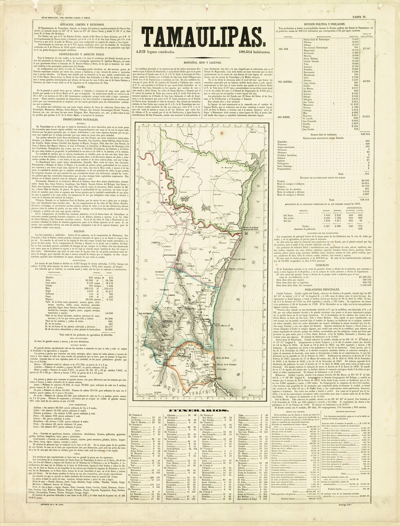
Tamaulipas
-
Map/Doc
94563
-
Collection
Non-GLO Digital Images
-
Object Dates
1858 (Creation Date)
-
People and Organizations
Antonio García y Cubas (Author)
-
Subjects
Mexico
-
Height x Width
29.3 x 22.3 inches
74.4 x 56.6 cm
-
Medium
digital image
-
Comments
Courtesy of the Mapoteca “Orozco y Berra” del Servicio de Información Agroalimentaria y Pesquera.
Reference: 1766-ATLAS-7216-A
Not available for duplication - for research purposes only. -
URLs
https://medium.com/save-texas-history/locating-the-in-between-south-texas-and-antonio-garc%C3%ADa-cubas-map-of-tamaulipas-1858-5f170e7d3006
Part of: Non-GLO Digital Images

Map of the United States Exhibiting the grants of lands made by the general government to aid in the construction of railroads and wagon roads

Print $20.00
Map of the United States Exhibiting the grants of lands made by the general government to aid in the construction of railroads and wagon roads
1878
Size 20.8 x 29.4 inches
Map/Doc 95286
A Geological Map of the United States and Canada

Print $20.00
A Geological Map of the United States and Canada
1853
Size 17.4 x 25.0 inches
Map/Doc 95189
Plano de la Sauteña. Indicando los terrenos irrigados en Texas

Plano de la Sauteña. Indicando los terrenos irrigados en Texas
Size 38.6 x 37.8 inches
Map/Doc 94566
Carta geográfica que comprende en su extensión mucha parte del arzobispado de México, y alguna de los obispados de Puebla, Valladolid de Michoacán, Guadalajara y Durango, confinantes entre si

Carta geográfica que comprende en su extensión mucha parte del arzobispado de México, y alguna de los obispados de Puebla, Valladolid de Michoacán, Guadalajara y Durango, confinantes entre si
1779
Size 33.9 x 22.0 inches
Map/Doc 97079
Carta Esférica del Seno Mexicano y Canales Viexo y de Bama

Carta Esférica del Seno Mexicano y Canales Viexo y de Bama
1797
Size 26.7 x 47.1 inches
Map/Doc 94569
City of Round Rock, Texas

Print $20.00
City of Round Rock, Texas
1958
Size 25.3 x 31.5 inches
Map/Doc 87359


Descripción y Mapa de la Nueva Provincia, poblada de Bárbaros, situada en la Costa del Seno Mexicano, desde el puerto de Tampico hasta la Provincia de Texas

Descripción y Mapa de la Nueva Provincia, poblada de Bárbaros, situada en la Costa del Seno Mexicano, desde el puerto de Tampico hasta la Provincia de Texas
1744
Size 32.0 x 29.1 inches
Map/Doc 94558
[WWI Topographic Planning Map of the Ardennes department] - Verso
![94130, [WWI Topographic Planning Map of the Ardennes department] - Verso, Non-GLO Digital Images](https://historictexasmaps.com/wmedia_w700/maps/94130-1.tif.jpg)
Print $20.00
[WWI Topographic Planning Map of the Ardennes department] - Verso
1918
Size 35.9 x 20.4 inches
Map/Doc 94130
Map of Texas from the most recent authorities

Print $20.00
Map of Texas from the most recent authorities
1845
Size 13.5 x 17.1 inches
Map/Doc 94574
You may also like
English Field Notes of the Spanish Archives - Book 7

English Field Notes of the Spanish Archives - Book 7
1835
Map/Doc 96533

Marion County Rolled Sketch 8

Print $20.00
- Digital $50.00
Marion County Rolled Sketch 8
1998
Size 33.0 x 22.1 inches
Map/Doc 6661
Terrell County Working Sketch 19

Print $20.00
- Digital $50.00
Terrell County Working Sketch 19
1932
Size 18.8 x 25.7 inches
Map/Doc 62169
Bell County Working Sketch 15

Print $20.00
- Digital $50.00
Bell County Working Sketch 15
1979
Size 15.7 x 16.2 inches
Map/Doc 67355
Real County Working Sketch 16

Print $20.00
- Digital $50.00
Real County Working Sketch 16
1941
Size 28.2 x 40.1 inches
Map/Doc 71908
Concho County Sketch File 51

Print $24.00
- Digital $50.00
Concho County Sketch File 51
1971
Size 11.1 x 8.6 inches
Map/Doc 19218
The Peters Colony. January 20, 1843

Print $20.00
The Peters Colony. January 20, 1843
2020
Size 17.2 x 21.7 inches
Map/Doc 96365
Wharton County Working Sketch 9

Print $3.00
- Digital $50.00
Wharton County Working Sketch 9
1982
Size 12.4 x 10.4 inches
Map/Doc 72473
San Patricio County Sketch File 11

Print $6.00
San Patricio County Sketch File 11
1846
Size 13.3 x 8.3 inches
Map/Doc 36044
Map Exhibiting the line of the Southern Trans-Continental R.R. from Marshall to Texarkana from Texarkana to Forth Worth

Print $20.00
- Digital $50.00
Map Exhibiting the line of the Southern Trans-Continental R.R. from Marshall to Texarkana from Texarkana to Forth Worth
1872
Size 24.6 x 47.8 inches
Map/Doc 64241
Flight Mission No. CGI-3N, Frame 111, Cameron County

Print $20.00
- Digital $50.00
Flight Mission No. CGI-3N, Frame 111, Cameron County
1954
Size 18.6 x 22.2 inches
Map/Doc 84591