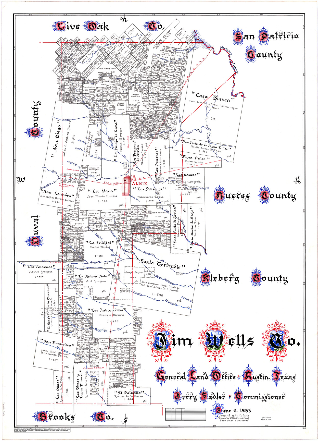
Jim Wells Co.
General Land Office Official County Map
-
Map/Doc
95548
-
Collection
General Map Collection
-
Object Dates
2019/8/31 (Revision Date)
1966/6/8 (Creation Date)
-
People and Organizations
Cheyenne Betancourt (Draftsman)
Eltea Armstrong (Draftsman)
M. L. Liles (Compiler)
Jerry Sadler (GLO Commissioner)
-
Counties
Jim Wells
-
Subjects
County OCM
-
Height x Width
43.8 x 32.4 inches
111.3 x 82.3 cm
-
Medium
digital image
-
Scale
1" = 3000 varas
Part of: General Map Collection
Terrell County Sketch File 24a

Print $20.00
- Digital $50.00
Terrell County Sketch File 24a
1932
Size 30.4 x 42.2 inches
Map/Doc 10388
Atascosa County Sketch File 6

Print $26.00
- Digital $50.00
Atascosa County Sketch File 6
Size 12.2 x 7.8 inches
Map/Doc 13752
Fort Bend County Rolled Sketch A

Print $20.00
- Digital $50.00
Fort Bend County Rolled Sketch A
1900
Size 19.8 x 29.7 inches
Map/Doc 5903
Harrison County Sketch File 14

Print $32.00
- Digital $50.00
Harrison County Sketch File 14
1880
Size 11.2 x 8.8 inches
Map/Doc 26053
Supreme Court of the United States, October Term, 1930, No.2, Original - The State of New Mexico, Complainant vs. The State of Texas, Defendant

Print $138.00
- Digital $50.00
Supreme Court of the United States, October Term, 1930, No.2, Original - The State of New Mexico, Complainant vs. The State of Texas, Defendant
Size 9.2 x 6.0 inches
Map/Doc 95287
Flight Mission No. DAG-23K, Frame 166, Matagorda County

Print $20.00
- Digital $50.00
Flight Mission No. DAG-23K, Frame 166, Matagorda County
1953
Size 15.9 x 19.1 inches
Map/Doc 86504
Texas-Oklahoma Paris Quadrangle

Print $20.00
- Digital $50.00
Texas-Oklahoma Paris Quadrangle
Size 22.3 x 18.4 inches
Map/Doc 75107
Texas Intracoastal Waterway - Stover Point to Port Brownsville including Brazos Santiago

Print $20.00
- Digital $50.00
Texas Intracoastal Waterway - Stover Point to Port Brownsville including Brazos Santiago
1965
Size 27.5 x 38.9 inches
Map/Doc 73521
Dickens County Rolled Sketch C

Print $20.00
- Digital $50.00
Dickens County Rolled Sketch C
1895
Size 20.5 x 25.5 inches
Map/Doc 5710
Flight Mission No. CRE-3R, Frame 40, Jackson County

Print $20.00
- Digital $50.00
Flight Mission No. CRE-3R, Frame 40, Jackson County
1956
Size 18.6 x 22.3 inches
Map/Doc 85387
Harris County Working Sketch Graphic Index, Sheet 1 (Sketches 1 to 68)

Print $20.00
- Digital $50.00
Harris County Working Sketch Graphic Index, Sheet 1 (Sketches 1 to 68)
1940
Size 38.4 x 46.1 inches
Map/Doc 76568
El Paso County Working Sketch 6

Print $20.00
- Digital $50.00
El Paso County Working Sketch 6
1928
Size 25.4 x 16.7 inches
Map/Doc 69028
You may also like
The Republic County of Rusk. February 1, 1845

Print $20.00
The Republic County of Rusk. February 1, 1845
2020
Size 19.1 x 21.7 inches
Map/Doc 96267
[G. H. & H. Block 2]
![90714, [G. H. & H. Block 2], Twichell Survey Records](https://historictexasmaps.com/wmedia_w700/maps/90714-1.tif.jpg)
Print $20.00
- Digital $50.00
[G. H. & H. Block 2]
Size 24.1 x 18.5 inches
Map/Doc 90714
Borden County Rolled Sketch 3

Print $20.00
- Digital $50.00
Borden County Rolled Sketch 3
1908
Size 29.0 x 33.6 inches
Map/Doc 5155
Bowie County Sketch File 8e

Print $12.00
- Digital $50.00
Bowie County Sketch File 8e
1928
Size 8.0 x 5.2 inches
Map/Doc 14896
Kerr County Sketch File 1c

Print $4.00
- Digital $50.00
Kerr County Sketch File 1c
1951
Size 12.3 x 8.3 inches
Map/Doc 28851
[Blocks A-23, A-26, and A-31]
![92673, [Blocks A-23, A-26, and A-31], Twichell Survey Records](https://historictexasmaps.com/wmedia_w700/maps/92673-1.tif.jpg)
Print $20.00
- Digital $50.00
[Blocks A-23, A-26, and A-31]
1954
Size 18.1 x 9.0 inches
Map/Doc 92673
Map of Titus County

Print $20.00
- Digital $50.00
Map of Titus County
1857
Size 23.8 x 34.3 inches
Map/Doc 4857
Blanco County Sketch File 21b

Print $40.00
- Digital $50.00
Blanco County Sketch File 21b
1882
Size 16.9 x 17.8 inches
Map/Doc 10930
Tarrant County Sketch File 33

Print $48.00
- Digital $50.00
Tarrant County Sketch File 33
1954
Size 11.6 x 8.8 inches
Map/Doc 37759
Zavala County Working Sketch 19

Print $40.00
- Digital $50.00
Zavala County Working Sketch 19
1978
Size 16.2 x 59.1 inches
Map/Doc 62094
Nacogdoches County Sketch File 10

Print $6.00
- Digital $50.00
Nacogdoches County Sketch File 10
1886
Size 12.9 x 11.0 inches
Map/Doc 32253
City and Harbor of Port Arthur Texas, Bird's Eye View Looking South to the Gulf of Mexico

Print $20.00
City and Harbor of Port Arthur Texas, Bird's Eye View Looking South to the Gulf of Mexico
1912
Size 17.4 x 39.9 inches
Map/Doc 93483