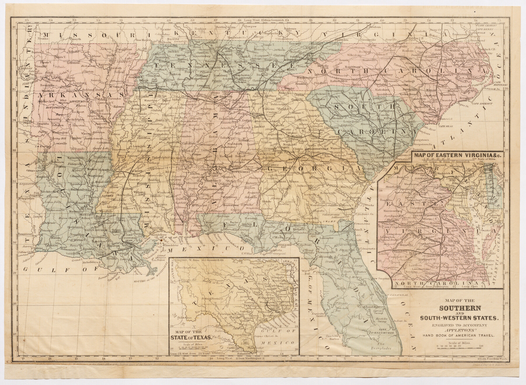
Map of the Southern and South-western States engraved to accompany Appletons' hand book of American travel
[Inset 1:] Map of Eastern Virginia & c. [Inset 2:] Map of the State of Texas
-
Map/Doc
95902
-
Collection
Cobb Digital Map Collection
-
Object Dates
1849 (Creation Date)
-
People and Organizations
W. Williams (Printer)
W. Williams (Draftsman)
W. Williams (Engraver)
-
Subjects
Railroads State of Texas United States
-
Height x Width
13.0 x 17.8 inches
33.0 x 45.2 cm
-
Medium
digital image
-
Comments
Courtesy of John & Diana Cobb.
Part of: Cobb Digital Map Collection
Souvenir of Galveston the Sea Wall City

Souvenir of Galveston the Sea Wall City
Size 5.7 x 7.6 inches
Map/Doc 97051
Southern Pacific Lines Map of Texas

Print $20.00
- Digital $50.00
Southern Pacific Lines Map of Texas
1928
Size 27.4 x 22.4 inches
Map/Doc 95774
The Texas and Oklahoma Official Railway & Hotel Guide Map

Print $20.00
- Digital $50.00
The Texas and Oklahoma Official Railway & Hotel Guide Map
1918
Size 23.4 x 24.0 inches
Map/Doc 95893
The Lower Valley of the Rio Grande Irrigated Farm Lands

Print $20.00
- Digital $50.00
The Lower Valley of the Rio Grande Irrigated Farm Lands
1918
Size 24.5 x 18.7 inches
Map/Doc 96730
Geographically Correct County Map showing the lines of the Cotton Belt Route and connections

Print $20.00
- Digital $50.00
Geographically Correct County Map showing the lines of the Cotton Belt Route and connections
1902
Size 35.9 x 30.7 inches
Map/Doc 95840
New and Correct Map of the Great Rock Island Route - Chicago, Rock Island, & Pacific Railway

Print $20.00
- Digital $50.00
New and Correct Map of the Great Rock Island Route - Chicago, Rock Island, & Pacific Railway
1892
Size 20.0 x 42.2 inches
Map/Doc 95865
[Map 1:] A Geographically Correct County Map of States Traversed by the St. Louis, Iron Mountain and Southern Railway and its connections / [Map 2:] Map of the St. Louis, Iron Mountain and Southern Railway, and connections
![95784, [Map 1:] A Geographically Correct County Map of States Traversed by the St. Louis, Iron Mountain and Southern Railway and its connections / [Map 2:] Map of the St. Louis, Iron Mountain and Southern Railway, and connections, Cobb Digital Map Collection - 1](https://historictexasmaps.com/wmedia_w700/maps/95784.tif.jpg)
Print $20.00
- Digital $50.00
[Map 1:] A Geographically Correct County Map of States Traversed by the St. Louis, Iron Mountain and Southern Railway and its connections / [Map 2:] Map of the St. Louis, Iron Mountain and Southern Railway, and connections
1878
Size 18.9 x 32.2 inches
Map/Doc 95784

Map of Texas with population and location of principal towns and cities according to latest reliable statistics

Print $20.00
- Digital $50.00
Map of Texas with population and location of principal towns and cities according to latest reliable statistics
1908
Size 18.5 x 20.4 inches
Map/Doc 95873
Correct Map of the Missouri, Kansas & Texas Railway and connections

Print $20.00
- Digital $50.00
Correct Map of the Missouri, Kansas & Texas Railway and connections
1895
Size 17.9 x 39.8 inches
Map/Doc 95808
The Principal Transportation Lines extending west from Boston, New York, Philadelphia, and Baltimore

Print $20.00
- Digital $50.00
The Principal Transportation Lines extending west from Boston, New York, Philadelphia, and Baltimore
1881
Size 17.1 x 24.4 inches
Map/Doc 95908
Houston - Where Seventeen Railroads Meet the Sea

Houston - Where Seventeen Railroads Meet the Sea
1913
Size 6.1 x 8.2 inches
Map/Doc 97069
You may also like
Nolan County Rolled Sketch W

Print $20.00
- Digital $50.00
Nolan County Rolled Sketch W
1902
Size 16.5 x 38.0 inches
Map/Doc 6863
Flight Mission No. CRE-2R, Frame 168, Jackson County

Print $20.00
- Digital $50.00
Flight Mission No. CRE-2R, Frame 168, Jackson County
1956
Size 18.5 x 22.3 inches
Map/Doc 85378
Map of Survey in Dimmit and Webb Counties

Print $40.00
- Digital $50.00
Map of Survey in Dimmit and Webb Counties
1913
Size 31.3 x 71.0 inches
Map/Doc 75829
Current Miscellaneous File 36

Print $12.00
- Digital $50.00
Current Miscellaneous File 36
Size 10.3 x 12.4 inches
Map/Doc 73952
Brazoria County Rolled Sketch 49

Print $20.00
- Digital $50.00
Brazoria County Rolled Sketch 49
1948
Size 23.8 x 36.1 inches
Map/Doc 5182
Hudspeth County Sketch File 31

Print $20.00
- Digital $50.00
Hudspeth County Sketch File 31
1908
Size 18.7 x 17.7 inches
Map/Doc 11805
Map of County Roads in Moore County

Print $20.00
- Digital $50.00
Map of County Roads in Moore County
Size 22.2 x 21.2 inches
Map/Doc 93005
Flight Mission No. DAG-21K, Frame 129, Matagorda County

Print $20.00
- Digital $50.00
Flight Mission No. DAG-21K, Frame 129, Matagorda County
1952
Size 18.6 x 22.5 inches
Map/Doc 86455
Austin County Boundary File 5a

Print $6.00
- Digital $50.00
Austin County Boundary File 5a
Size 14.1 x 8.7 inches
Map/Doc 50252
A New Map of Texas, Oregon, and California with the regions adjoining compiled from the most recent authorities

Print $20.00
- Digital $50.00
A New Map of Texas, Oregon, and California with the regions adjoining compiled from the most recent authorities
1846
Size 23.0 x 21.2 inches
Map/Doc 95748
Map of a Part of Robertson Colony

Print $20.00
- Digital $50.00
Map of a Part of Robertson Colony
1843
Size 32.2 x 22.6 inches
Map/Doc 168
Minutes of the Ayuntamiento of San Felipe de Austin Vol. 2

Minutes of the Ayuntamiento of San Felipe de Austin Vol. 2
Size 13.3 x 10.5 inches
Map/Doc 94261