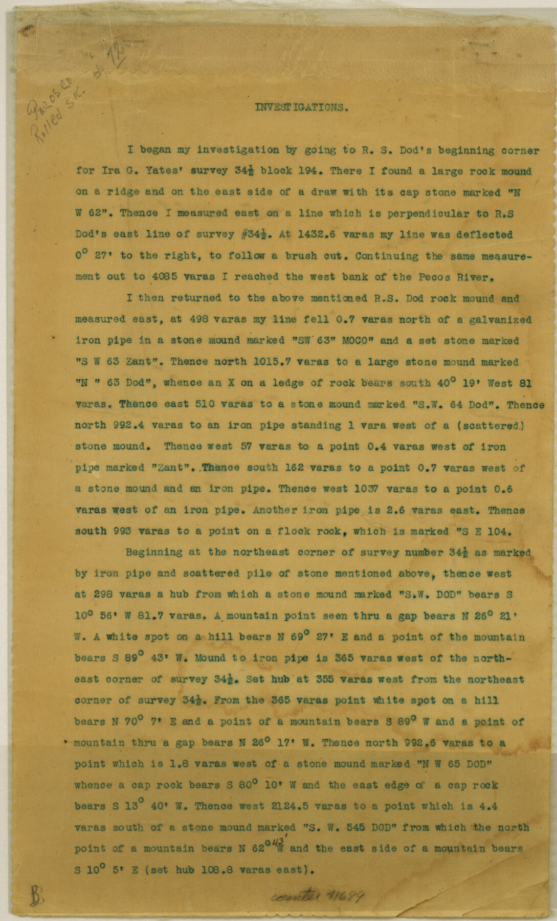
Pecos County Rolled Sketch 72
[Sketch and investigation of area around Runnels County School Land no. 3]
-
Map/Doc
9704
-
Collection
General Map Collection
-
Object Dates
1934/10/29 (Creation Date)
-
People and Organizations
A.N. Lea (Surveyor/Engineer)
-
Counties
Pecos
-
Subjects
Surveying Rolled Sketch
-
Height x Width
35.8 x 45.1 inches
90.9 x 114.6 cm
-
Medium
multi-page, multi-format
Part of: General Map Collection
Kenedy County Working Sketch 2a

Print $20.00
- Digital $50.00
Kenedy County Working Sketch 2a
1907
Size 22.2 x 20.9 inches
Map/Doc 70003

City of Washington

Print $20.00
- Digital $50.00
City of Washington
1846
Size 14.1 x 18.0 inches
Map/Doc 95358
King County Rolled Sketch 13

Print $40.00
- Digital $50.00
King County Rolled Sketch 13
Size 50.5 x 29.3 inches
Map/Doc 9353
Angelina County Working Sketch 29

Print $20.00
- Digital $50.00
Angelina County Working Sketch 29
1955
Size 24.9 x 23.3 inches
Map/Doc 67111
Flight Mission No. DQN-2K, Frame 144, Calhoun County

Print $20.00
- Digital $50.00
Flight Mission No. DQN-2K, Frame 144, Calhoun County
1953
Size 18.7 x 22.4 inches
Map/Doc 84313
Brooks County Rolled Sketch 22

Print $20.00
- Digital $50.00
Brooks County Rolled Sketch 22
1943
Size 15.1 x 32.2 inches
Map/Doc 5343
Sutton County Working Sketch 51

Print $20.00
- Digital $50.00
Sutton County Working Sketch 51
1955
Size 12.1 x 27.7 inches
Map/Doc 62394
Chambers County Rolled Sketch 21

Print $20.00
- Digital $50.00
Chambers County Rolled Sketch 21
1940
Size 40.9 x 41.0 inches
Map/Doc 8589
Wheeler County Working Sketch 2

Print $40.00
- Digital $50.00
Wheeler County Working Sketch 2
1957
Size 35.2 x 58.5 inches
Map/Doc 72491
Nueces County Navigation District Number One, Submerged Lands Maintained for Navigational Purposes Persuant to Sub-Section G of Section 61.117 Texas Water Code

Print $20.00
- Digital $50.00
Nueces County Navigation District Number One, Submerged Lands Maintained for Navigational Purposes Persuant to Sub-Section G of Section 61.117 Texas Water Code
1975
Size 23.3 x 29.9 inches
Map/Doc 61806
Garza County Sketch File G-1

Print $20.00
- Digital $50.00
Garza County Sketch File G-1
1904
Size 20.4 x 20.6 inches
Map/Doc 11554
You may also like
Edwards County Rolled Sketch 17

Print $20.00
- Digital $50.00
Edwards County Rolled Sketch 17
1945
Size 27.6 x 19.4 inches
Map/Doc 5806

Old Miscellaneous File 25

Print $40.00
- Digital $50.00
Old Miscellaneous File 25
Size 17.8 x 15.2 inches
Map/Doc 75632
Zavala County Working Sketch 13

Print $20.00
- Digital $50.00
Zavala County Working Sketch 13
1975
Size 20.1 x 27.4 inches
Map/Doc 62088
Tyler County Rolled Sketch 9

Print $20.00
- Digital $50.00
Tyler County Rolled Sketch 9
Size 43.3 x 25.6 inches
Map/Doc 8059
Map of Parts of Dawson and Borden Counties

Print $20.00
- Digital $50.00
Map of Parts of Dawson and Borden Counties
Size 22.7 x 17.6 inches
Map/Doc 92034
Runnels County Rolled Sketch 35

Print $20.00
- Digital $50.00
Runnels County Rolled Sketch 35
1950
Size 34.1 x 44.6 inches
Map/Doc 7523
Morris County Rolled Sketch 2A

Print $20.00
- Digital $50.00
Morris County Rolled Sketch 2A
Size 24.1 x 18.9 inches
Map/Doc 10278
Travis County Appraisal District Plat Map 1_0204

Print $20.00
- Digital $50.00
Travis County Appraisal District Plat Map 1_0204
Size 21.7 x 26.6 inches
Map/Doc 94207

[Brooks & Burleson Block 4, Hartley County]
![5037, [Brooks & Burleson Block 4, Hartley County], Maddox Collection](https://historictexasmaps.com/wmedia_w700/maps/5037.tif.jpg)
Print $3.00
- Digital $50.00
[Brooks & Burleson Block 4, Hartley County]
Size 10.3 x 9.5 inches
Map/Doc 5037
Hardin County Sketch File AB

Print $4.00
- Digital $50.00
Hardin County Sketch File AB
Size 13.5 x 7.3 inches
Map/Doc 25071