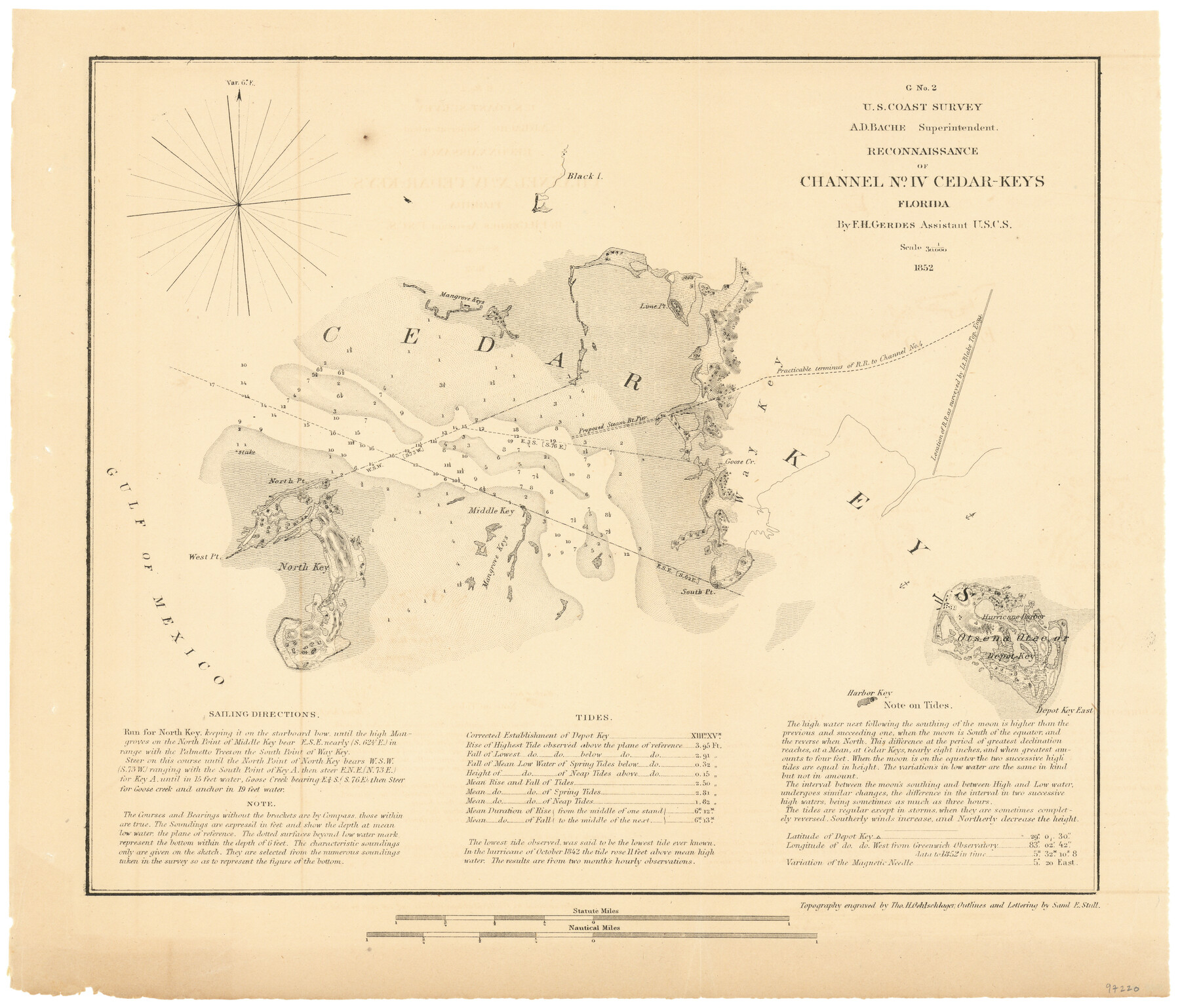
G No. 2 - Reconnaissance of Channel No. IV Cedar-Keys, Florida
-
Map/Doc
97220
-
Collection
General Map Collection
-
Object Dates
1852 (Creation Date)
-
People and Organizations
A.D. Bache (Superintendent)
F.H. Gerdes (Surveyor/Engineer)
U.S. Coast Survey (Publisher)
-
Subjects
Coastal
-
Height x Width
10.8 x 12.6 inches
27.4 x 32.0 cm
-
Comments
Sketch from the book "Report of the Superintendent of the Coast Survey Showing the Progress of the Survey in the year 1852" (81738)
Related maps
Report of the Superintendent of the Coast Survey showing the progress of the survey during the year 1852

Report of the Superintendent of the Coast Survey showing the progress of the survey during the year 1852
1853
Map/Doc 81738
Part of: General Map Collection
Gulf Intracoastal Waterway, Tex. - Aransas Bay to Corpus Christi Bay - Modified Route of Main Channel/Dredging

Print $20.00
- Digital $50.00
Gulf Intracoastal Waterway, Tex. - Aransas Bay to Corpus Christi Bay - Modified Route of Main Channel/Dredging
1958
Size 31.3 x 42.8 inches
Map/Doc 61899
Polk County Sketch File 38

Print $20.00
- Digital $50.00
Polk County Sketch File 38
Size 13.9 x 8.8 inches
Map/Doc 34268
Armstrong County Sketch File A-4

Print $40.00
- Digital $50.00
Armstrong County Sketch File A-4
Size 14.8 x 20.5 inches
Map/Doc 10845
Flight Mission No. DQN-1K, Frame 114, Calhoun County

Print $20.00
- Digital $50.00
Flight Mission No. DQN-1K, Frame 114, Calhoun County
1953
Size 18.5 x 22.3 inches
Map/Doc 84180
Hall County Sketch File 10

Print $20.00
- Digital $50.00
Hall County Sketch File 10
1884
Size 19.6 x 22.1 inches
Map/Doc 11605
Young County Sketch File 10a

Print $4.00
- Digital $50.00
Young County Sketch File 10a
1879
Size 8.0 x 7.5 inches
Map/Doc 40868

Coryell County Milam District

Print $20.00
- Digital $50.00
Coryell County Milam District
1883
Size 25.7 x 24.6 inches
Map/Doc 3446
Foard County Sketch File 26

Print $40.00
- Digital $50.00
Foard County Sketch File 26
Size 13.5 x 17.7 inches
Map/Doc 22856
Hunt County Sketch File 31

Print $6.00
- Digital $50.00
Hunt County Sketch File 31
1862
Size 9.8 x 8.0 inches
Map/Doc 27135
State of Texas

Print $40.00
- Digital $50.00
State of Texas
1965
Size 42.8 x 52.5 inches
Map/Doc 2095
Map of Colorado County

Print $20.00
- Digital $50.00
Map of Colorado County
1880
Size 21.8 x 21.1 inches
Map/Doc 3426
You may also like
Map of The Surveyed Part of Peters Colony Texas

Print $40.00
- Digital $50.00
Map of The Surveyed Part of Peters Colony Texas
1852
Size 56.5 x 41.0 inches
Map/Doc 1966
Terry County Sketch File 5

Print $40.00
- Digital $50.00
Terry County Sketch File 5
1916
Size 15.6 x 58.6 inches
Map/Doc 10391
Flight Mission No. CZW-1R, Frame 165, Hardeman County

Print $20.00
- Digital $50.00
Flight Mission No. CZW-1R, Frame 165, Hardeman County
1956
Size 18.7 x 22.4 inches
Map/Doc 85236
Rusk County Rolled Sketch 15

Print $40.00
- Digital $50.00
Rusk County Rolled Sketch 15
2000
Size 62.4 x 21.2 inches
Map/Doc 10636
Brewster County Working Sketch 118.2

Print $20.00
- Digital $50.00
Brewster County Working Sketch 118.2
Size 26.8 x 20.6 inches
Map/Doc 67871
Military Reconnaissance [showing forts along Rio Grande near Matamoros]
![72912, Military Reconnaissance [showing forts along Rio Grande near Matamoros], General Map Collection](https://historictexasmaps.com/wmedia_w700/maps/72912.tif.jpg)
Print $20.00
- Digital $50.00
Military Reconnaissance [showing forts along Rio Grande near Matamoros]
1846
Size 18.3 x 27.0 inches
Map/Doc 72912
Galveston County Rolled Sketch DB

Print $20.00
- Digital $50.00
Galveston County Rolled Sketch DB
Size 37.0 x 47.5 inches
Map/Doc 9854
Goliad County Sketch File 24

Print $16.00
- Digital $50.00
Goliad County Sketch File 24
1856
Size 12.9 x 8.2 inches
Map/Doc 24297
Frio County Rolled Sketch 5

Print $20.00
- Digital $50.00
Frio County Rolled Sketch 5
Size 25.7 x 23.0 inches
Map/Doc 5917
The Sunshine Special - Quickest of 'em all - Hosuton to St. Louis leaves Houston 12:45 p.m. San Antonio 9 a.m.

Print $20.00
- Digital $50.00
The Sunshine Special - Quickest of 'em all - Hosuton to St. Louis leaves Houston 12:45 p.m. San Antonio 9 a.m.
1925
Size 9.0 x 7.7 inches
Map/Doc 95780
Map of Henderson County

Print $40.00
- Digital $50.00
Map of Henderson County
1897
Size 27.7 x 56.8 inches
Map/Doc 16849
Live Oak County Working Sketch 34

Print $20.00
- Digital $50.00
Live Oak County Working Sketch 34
Size 31.0 x 42.6 inches
Map/Doc 78469