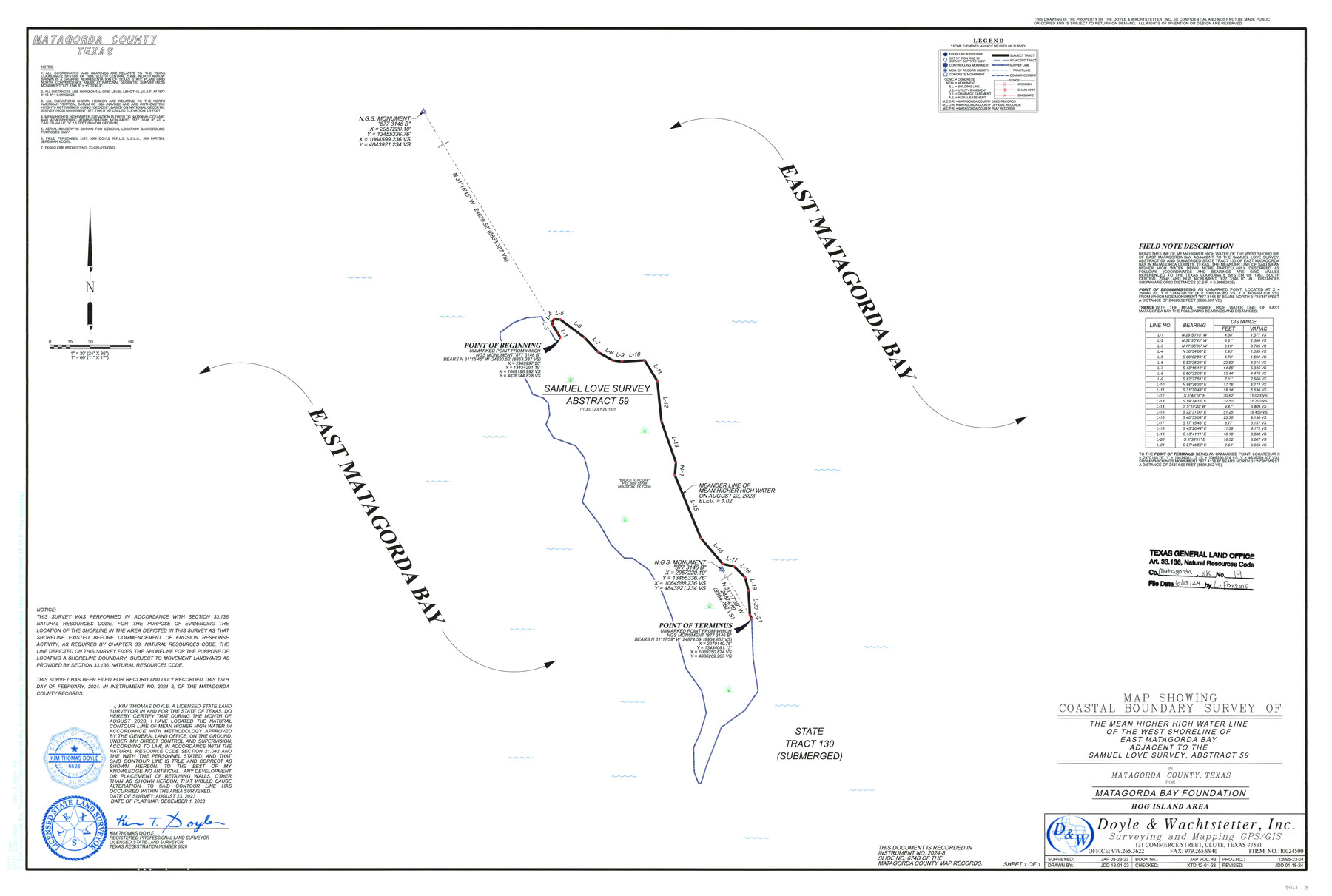
Matagorda County NRC Article 33.136 Sketch 19
Map showing Coastal Boundary Survey of the mean higher high water line of the west shoreline of East Matagorda Bay adjacent to the Samuel Love Survey, Abstract 59
-
Map/Doc
97268
-
Collection
General Map Collection
-
Object Dates
12/1/2023 (Creation Date)
6/13/2024 (File Date)
8/23/2023 (Survey Date)
1/18/2024 (Revision Date)
-
People and Organizations
Kim Thomas Doyle (Surveyor/Engineer)
-
Counties
Matagorda
-
Subjects
Surveying CBS
-
Scale
1"= 30 feet
-
Comments
Project: Matagorda Bay Foundation - Hog Island Area, Matagorda County
Project No.: TGLO CMP No. 23-020-013-D607
Part of: General Map Collection
Frio County Sketch File 16

Print $8.00
- Digital $50.00
Frio County Sketch File 16
1949
Size 11.3 x 8.8 inches
Map/Doc 23148

Concho County Working Sketch 3

Print $20.00
- Digital $50.00
Concho County Working Sketch 3
1918
Size 24.0 x 22.2 inches
Map/Doc 68185
Flight Mission No. CGI-3N, Frame 71, Cameron County

Print $20.00
- Digital $50.00
Flight Mission No. CGI-3N, Frame 71, Cameron County
1954
Size 18.4 x 22.3 inches
Map/Doc 84565
Haskell County Working Sketch 12

Print $20.00
- Digital $50.00
Haskell County Working Sketch 12
1979
Size 39.3 x 44.2 inches
Map/Doc 66070
Grayson County

Print $20.00
- Digital $50.00
Grayson County
1935
Size 42.4 x 39.5 inches
Map/Doc 73162
Orange County Working Sketch 47

Print $20.00
- Digital $50.00
Orange County Working Sketch 47
1987
Size 27.5 x 26.5 inches
Map/Doc 71379
[San Antonio & Aransas Pass Railway Co.]
![64261, [San Antonio & Aransas Pass Railway Co.], General Map Collection](https://historictexasmaps.com/wmedia_w700/maps/64261.tif.jpg)
Print $20.00
- Digital $50.00
[San Antonio & Aransas Pass Railway Co.]
Size 22.9 x 35.1 inches
Map/Doc 64261
Zavala County Rolled Sketch 23

Print $20.00
- Digital $50.00
Zavala County Rolled Sketch 23
1943
Size 17.0 x 25.6 inches
Map/Doc 8326
Upton County Working Sketch 33

Print $20.00
- Digital $50.00
Upton County Working Sketch 33
1955
Size 17.9 x 37.8 inches
Map/Doc 69529
Map of Chicago, Rock Island & Texas Railroad

Print $40.00
- Digital $50.00
Map of Chicago, Rock Island & Texas Railroad
1892
Size 23.9 x 122.0 inches
Map/Doc 64442
Sectional Map No. 3 of the lands and of the line of the Texas & Pacific Ry. Co. in Reeves and parts of Tom Green, Pecos, Presidio & El Paso Cos.

Print $20.00
- Digital $50.00
Sectional Map No. 3 of the lands and of the line of the Texas & Pacific Ry. Co. in Reeves and parts of Tom Green, Pecos, Presidio & El Paso Cos.
1885
Size 24.2 x 18.9 inches
Map/Doc 4858
You may also like

[F. W. & D. C. Ry. Co. Alignment and Right of Way Map, Clay County]
![64723, [F. W. & D. C. Ry. Co. Alignment and Right of Way Map, Clay County], General Map Collection](https://historictexasmaps.com/wmedia_w700/maps/64723-1.tif.jpg)
Print $20.00
- Digital $50.00
[F. W. & D. C. Ry. Co. Alignment and Right of Way Map, Clay County]
1927
Size 18.6 x 11.8 inches
Map/Doc 64723

Map of Blocks No. 46 and 47 made in the name of Houston and Texas Central RR. Co. in Oldham District

Print $20.00
- Digital $50.00
Map of Blocks No. 46 and 47 made in the name of Houston and Texas Central RR. Co. in Oldham District
1884
Size 40.8 x 27.0 inches
Map/Doc 91818
Flight Mission No. DCL-7C, Frame 62, Kenedy County

Print $20.00
- Digital $50.00
Flight Mission No. DCL-7C, Frame 62, Kenedy County
1943
Size 15.4 x 15.3 inches
Map/Doc 86050
Flight Mission No. DQN-1K, Frame 144, Calhoun County

Print $20.00
- Digital $50.00
Flight Mission No. DQN-1K, Frame 144, Calhoun County
1953
Size 18.5 x 22.2 inches
Map/Doc 84207
Baylor County

Print $20.00
- Digital $50.00
Baylor County
1961
Size 40.6 x 33.0 inches
Map/Doc 77209
Culberson County Sketch File 7

Print $8.00
- Digital $50.00
Culberson County Sketch File 7
1888
Size 14.5 x 8.8 inches
Map/Doc 20138
Oldham County Working Sketch 8

Print $20.00
- Digital $50.00
Oldham County Working Sketch 8
1982
Size 33.4 x 35.8 inches
Map/Doc 71330
Hudspeth County Sketch File 54

Print $4.00
- Digital $50.00
Hudspeth County Sketch File 54
1993
Size 8.9 x 14.2 inches
Map/Doc 27079
Map of a part of Fisher and Miller's Colony - Harvey's District

Print $20.00
- Digital $50.00
Map of a part of Fisher and Miller's Colony - Harvey's District
1856
Size 19.0 x 24.7 inches
Map/Doc 4657
2016 Official Travel Map, Texas

2016 Official Travel Map, Texas
Size 33.3 x 36.2 inches
Map/Doc 94297