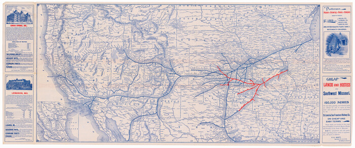
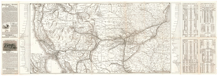
[The Frisco Line - St. Louis & San Francisco Railway through the Great West and South West]
Print $20.00
- Digital $50.00
[The Frisco Line - St. Louis & San Francisco Railway through the Great West and South West]
1893
Size: 16.8 x 40.2 inches
95794
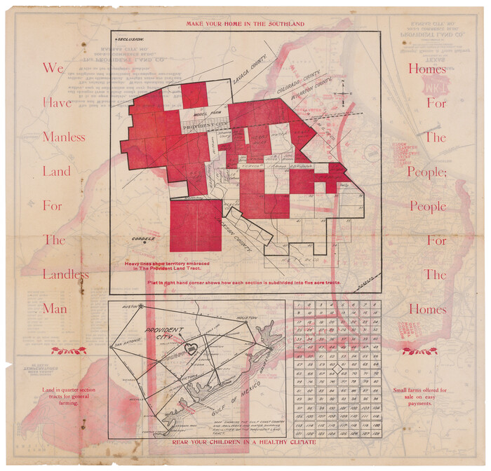
[Plat map of Provident City and surrounding] / Map showing the Gulf Coast Country and Railways and Water Shipping Facilities of the Provident Land Tract
Print $20.00
- Digital $50.00
[Plat map of Provident City and surrounding] / Map showing the Gulf Coast Country and Railways and Water Shipping Facilities of the Provident Land Tract
1908
Size: 22.0 x 22.9 inches
95819
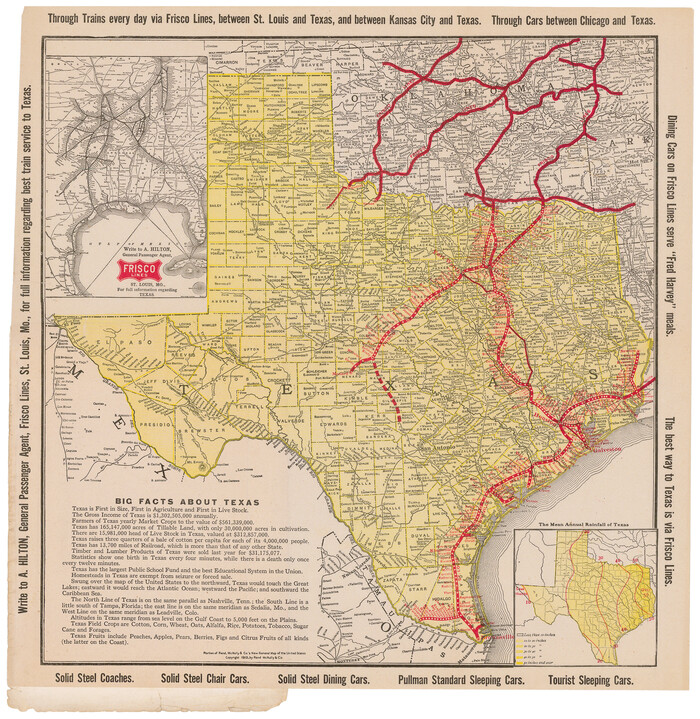
[Map of Texas showing Frisco Lines]
Print $20.00
- Digital $50.00
[Map of Texas showing Frisco Lines]
1910
Size: 19.8 x 19.2 inches
95796
[Map of Santa Fe Route - Atchison, Topeka, and Santa Fe Railroad]
Print $40.00
- Digital $50.00
[Map of Santa Fe Route - Atchison, Topeka, and Santa Fe Railroad]
1893
Size: 17.4 x 50.0 inches
95866
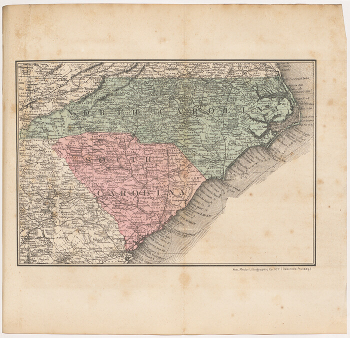
[Map of North Carolina and South Carolina]
Print $20.00
- Digital $50.00
[Map of North Carolina and South Carolina]
1869
Size: 8.9 x 9.2 inches
96621
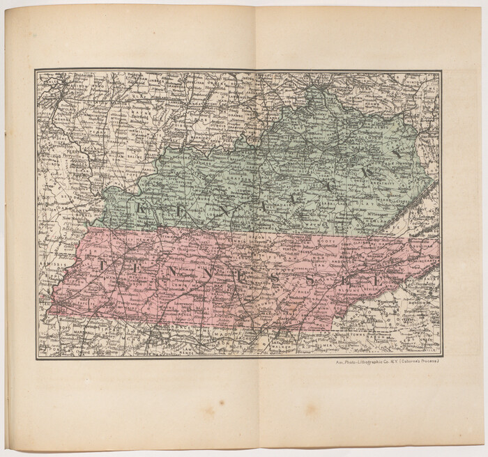
[Map of Kentucky and Tennessee]
Print $20.00
- Digital $50.00
[Map of Kentucky and Tennessee]
1869
Size: 8.9 x 9.5 inches
96623
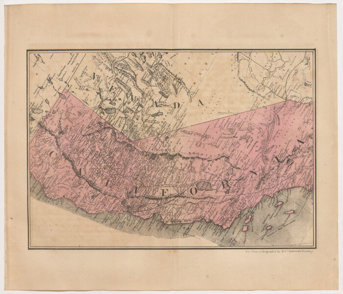
[Map of California and Nevada]
Print $20.00
- Digital $50.00
[Map of California and Nevada]
1869
Size: 9.1 x 10.6 inches
96620
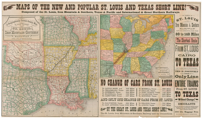
[Map 1:] A Geographically Correct County Map of States Traversed by the St. Louis, Iron Mountain and Southern Railway and its connections / [Map 2:] Map of the St. Louis, Iron Mountain and Southern Railway, and connections
Print $20.00
- Digital $50.00
[Map 1:] A Geographically Correct County Map of States Traversed by the St. Louis, Iron Mountain and Southern Railway and its connections / [Map 2:] Map of the St. Louis, Iron Mountain and Southern Railway, and connections
1878
Size: 18.9 x 32.2 inches
95784
Your Opportunity - the Magic Valley - Money Will Grow on Trees! Learn Where How and Why!

Your Opportunity - the Magic Valley - Money Will Grow on Trees! Learn Where How and Why!
1928
96740
Wright's Special Train between Kansas City and the Panhandle Country

Wright's Special Train between Kansas City and the Panhandle Country
1906
96752
What to See - Where to Go in El Paso, Texas

What to See - Where to Go in El Paso, Texas
1929
Size: 9.4 x 8.4 inches
97048
Victoria, Texas: The City of Roses

Victoria, Texas: The City of Roses
1910
Size: 3.6 x 4.8 inches
97056
Typical Scenes of Wichita Falls and District

Print $20.00
- Digital $50.00
Typical Scenes of Wichita Falls and District
1927
Size: 13.7 x 16.6 inches
96761
Tourists' Handbook Descriptive of Colorado, New Mexico and Utah

Tourists' Handbook Descriptive of Colorado, New Mexico and Utah
1898
Size: 9.4 x 6.4 inches
97075
Through Texas - a Series of Interesting and Instructive Letters

Through Texas - a Series of Interesting and Instructive Letters
1893
Size: 8.7 x 6.0 inches
96600
Three Through Trains for Texas Travelers via Katy Line - Missouri, Kansas and Texas Railway from Chicago, St. Louis, Kansas City and a comprehensive local service reaching all points in Missouri, Kansas, Texas and Indian Territory

Three Through Trains for Texas Travelers via Katy Line - Missouri, Kansas and Texas Railway from Chicago, St. Louis, Kansas City and a comprehensive local service reaching all points in Missouri, Kansas, Texas and Indian Territory
Size: 9.5 x 6.3 inches
96605
The Wonderful Lower Rio Grande Valley

Print $20.00
- Digital $50.00
The Wonderful Lower Rio Grande Valley
1909
Size: 21.6 x 22.9 inches
95798
The United States

Print $20.00
- Digital $50.00
The United States
1902
Size: 21.4 x 28.4 inches
95858
The United States

Print $20.00
- Digital $50.00
The United States
1907
Size: 21.1 x 28.3 inches
95859
[The Frisco Line - St. Louis & San Francisco Railway through the Great West and South West]
Print $20.00
- Digital $50.00
[The Frisco Line - St. Louis & San Francisco Railway through the Great West and South West]
1893
-
Size
16.8 x 40.2 inches
-
Map/Doc
95794
-
Creation Date
1893
[San Benito Promotional Booklet]
![[San Benito Promotional Booklet]](https://historictexasmaps.com/wmedia_w700/pdf_converted_jpg/qi_pdf_thumbnail_64211.jpg)
Print $16.00
[San Benito Promotional Booklet]
1913
-
Map/Doc
96728
-
Creation Date
1913
[Plat map of Provident City and surrounding] / Map showing the Gulf Coast Country and Railways and Water Shipping Facilities of the Provident Land Tract
Print $20.00
- Digital $50.00
[Plat map of Provident City and surrounding] / Map showing the Gulf Coast Country and Railways and Water Shipping Facilities of the Provident Land Tract
1908
-
Size
22.0 x 22.9 inches
-
Map/Doc
95819
-
Creation Date
1908
[Map of Texas]
![95882, [Map of Texas], Cobb Digital Map Collection - 1](https://historictexasmaps.com/wmedia_w700/maps/95882.tif.jpg)
Print $20.00
- Digital $50.00
[Map of Texas]
1908
-
Size
18.5 x 18.7 inches
-
Map/Doc
95882
-
Creation Date
1908
[Map of Texas]
![96624, [Map of Texas], Cobb Digital Map Collection](https://historictexasmaps.com/wmedia_w700/maps/96624.tif.jpg)
Print $20.00
- Digital $50.00
[Map of Texas]
1869
-
Size
9.9 x 8.8 inches
-
Map/Doc
96624
-
Creation Date
1869
[Map of Texas showing Frisco Lines]
Print $20.00
- Digital $50.00
[Map of Texas showing Frisco Lines]
1910
-
Size
19.8 x 19.2 inches
-
Map/Doc
95796
-
Creation Date
1910
[Map of Santa Fe Route - Atchison, Topeka, and Santa Fe Railroad]
Print $40.00
- Digital $50.00
[Map of Santa Fe Route - Atchison, Topeka, and Santa Fe Railroad]
1893
-
Size
17.4 x 50.0 inches
-
Map/Doc
95866
-
Creation Date
1893
[Map of North Carolina and South Carolina]
Print $20.00
- Digital $50.00
[Map of North Carolina and South Carolina]
1869
-
Size
8.9 x 9.2 inches
-
Map/Doc
96621
-
Creation Date
1869
[Map of Kentucky and Tennessee]
Print $20.00
- Digital $50.00
[Map of Kentucky and Tennessee]
1869
-
Size
8.9 x 9.5 inches
-
Map/Doc
96623
-
Creation Date
1869
[Map of Florida]
![96622, [Map of Florida], Cobb Digital Map Collection](https://historictexasmaps.com/wmedia_w700/maps/96622.tif.jpg)
Print $20.00
- Digital $50.00
[Map of Florida]
1869
-
Size
9.0 x 9.6 inches
-
Map/Doc
96622
-
Creation Date
1869
[Map of California and Nevada]
Print $20.00
- Digital $50.00
[Map of California and Nevada]
1869
-
Size
9.1 x 10.6 inches
-
Map/Doc
96620
-
Creation Date
1869
[Map 1:] A Geographically Correct County Map of States Traversed by the St. Louis, Iron Mountain and Southern Railway and its connections / [Map 2:] Map of the St. Louis, Iron Mountain and Southern Railway, and connections
Print $20.00
- Digital $50.00
[Map 1:] A Geographically Correct County Map of States Traversed by the St. Louis, Iron Mountain and Southern Railway and its connections / [Map 2:] Map of the St. Louis, Iron Mountain and Southern Railway, and connections
1878
-
Size
18.9 x 32.2 inches
-
Map/Doc
95784
-
Creation Date
1878
Your Opportunity - the Magic Valley - Money Will Grow on Trees! Learn Where How and Why!
Print $8.00
Your Opportunity - the Magic Valley - Money Will Grow on Trees! Learn Where How and Why!
1928
-
Map/Doc
96740
-
Creation Date
1928
Wright's Special Train between Kansas City and the Panhandle Country
Print $6.00
Wright's Special Train between Kansas City and the Panhandle Country
1906
-
Map/Doc
96752
-
Creation Date
1906
Where to Emigrate and Why

Where to Emigrate and Why
1869
-
Size
9.3 x 6.5 inches
-
Map/Doc
96610
-
Creation Date
1869
What to See - Where to Go in El Paso, Texas
What to See - Where to Go in El Paso, Texas
1929
-
Size
9.4 x 8.4 inches
-
Map/Doc
97048
-
Creation Date
1929
Wayside Notes East Bound Along Sunset Route

Print $40.00
Wayside Notes East Bound Along Sunset Route
1915
-
Map/Doc
96718
-
Creation Date
1915
Victoria, Texas: The City of Roses
Victoria, Texas: The City of Roses
1910
-
Size
3.6 x 4.8 inches
-
Map/Doc
97056
-
Creation Date
1910
Under Sapphire Skies in San Antonio

Under Sapphire Skies in San Antonio
1915
-
Map/Doc
96784
-
Creation Date
1915
Under Sapphire Skies San Antonio

Under Sapphire Skies San Antonio
1928
-
Size
9.4 x 6.4 inches
-
Map/Doc
97043
-
Creation Date
1928
Typical Scenes of Wichita Falls and District
Print $20.00
- Digital $50.00
Typical Scenes of Wichita Falls and District
1927
-
Size
13.7 x 16.6 inches
-
Map/Doc
96761
-
Creation Date
1927
Tourists' Handbook Descriptive of Colorado, New Mexico and Utah
Tourists' Handbook Descriptive of Colorado, New Mexico and Utah
1898
-
Size
9.4 x 6.4 inches
-
Map/Doc
97075
-
Creation Date
1898
Timely Tips to Texas Truckers

Timely Tips to Texas Truckers
1906
-
Size
9.3 x 6.2 inches
-
Map/Doc
96609
-
Creation Date
1906
Through Texas - a Series of Interesting and Instructive Letters
Through Texas - a Series of Interesting and Instructive Letters
1893
-
Size
8.7 x 6.0 inches
-
Map/Doc
96600
-
Creation Date
1893
Through Storyland to Sunset Seas

Through Storyland to Sunset Seas
1895
-
Size
8.9 x 6.7 inches
-
Map/Doc
96606
-
Creation Date
1895
Three Through Trains for Texas Travelers via Katy Line - Missouri, Kansas and Texas Railway from Chicago, St. Louis, Kansas City and a comprehensive local service reaching all points in Missouri, Kansas, Texas and Indian Territory
Three Through Trains for Texas Travelers via Katy Line - Missouri, Kansas and Texas Railway from Chicago, St. Louis, Kansas City and a comprehensive local service reaching all points in Missouri, Kansas, Texas and Indian Territory
-
Size
9.5 x 6.3 inches
-
Map/Doc
96605
The Wonderful Lower Rio Grande Valley
Print $20.00
- Digital $50.00
The Wonderful Lower Rio Grande Valley
1909
-
Size
21.6 x 22.9 inches
-
Map/Doc
95798
-
Creation Date
1909
The United States
Print $20.00
- Digital $50.00
The United States
1902
-
Size
21.4 x 28.4 inches
-
Map/Doc
95858
-
Creation Date
1902
The United States
Print $20.00
- Digital $50.00
The United States
1907
-
Size
21.1 x 28.3 inches
-
Map/Doc
95859
-
Creation Date
1907
The Truth about Texas

The Truth about Texas
1903
-
Size
7.2 x 5.2 inches
-
Map/Doc
96592
-
Creation Date
1903