Red River County, Texas

Print $20.00
- Digital $50.00
Red River County, Texas
Size: 22.2 x 17.2 inches
95756
Sectional map of Texas traversed by the Missouri, Kansas & Texas Railway, showing the crops adapted to each section, with the elevation and annual rainfall

Print $20.00
- Digital $50.00
Sectional map of Texas traversed by the Missouri, Kansas & Texas Railway, showing the crops adapted to each section, with the elevation and annual rainfall
Size: 21.9 x 22.8 inches
95818
Missouri, Kansas, & Texas Ry.

Print $20.00
- Digital $50.00
Missouri, Kansas, & Texas Ry.
Size: 6.7 x 5.4 inches
96598
Map of the Missouri, Kansas, & Texas Railway and Connecting Lines

Print $20.00
- Digital $50.00
Map of the Missouri, Kansas, & Texas Railway and Connecting Lines
Size: 11.2 x 17.2 inches
96599
Sectional Map of the Eastern Half of Texas traversed by the Missouri, Kansas & Texas Railway, showing the crops adapted to each section, with the elevation and average annual rainfall

Print $20.00
- Digital $50.00
Sectional Map of the Eastern Half of Texas traversed by the Missouri, Kansas & Texas Railway, showing the crops adapted to each section, with the elevation and average annual rainfall
Size: 18.3 x 14.7 inches
96602
Three Through Trains for Texas Travelers via Katy Line - Missouri, Kansas and Texas Railway from Chicago, St. Louis, Kansas City and a comprehensive local service reaching all points in Missouri, Kansas, Texas and Indian Territory

Three Through Trains for Texas Travelers via Katy Line - Missouri, Kansas and Texas Railway from Chicago, St. Louis, Kansas City and a comprehensive local service reaching all points in Missouri, Kansas, Texas and Indian Territory
Size: 9.5 x 6.3 inches
96605

Souvenir of Galveston the Sea Wall City

Souvenir of Galveston the Sea Wall City
Size: 5.7 x 7.6 inches
97051
Phelps's National Map of the United States, a Travellers Guide. Embracing the principal railroads, canals, steamboat & stage routes, throughout the Union

Print $20.00
- Digital $50.00
Phelps's National Map of the United States, a Travellers Guide. Embracing the principal railroads, canals, steamboat & stage routes, throughout the Union
1849
Size: 20.9 x 26.3 inches
95901
Map of the Southern and South-western States engraved to accompany Appletons' hand book of American travel

Print $20.00
- Digital $50.00
Map of the Southern and South-western States engraved to accompany Appletons' hand book of American travel
1849
Size: 13.0 x 17.8 inches
95902
Geological Map of the route explored by Lieut. A.W. Whipple, Corps of Topl. Engrs. near the Parallel of 35° North Latitude from the Mississippi River to the Pacific Ocean 1853-1854

Print $20.00
- Digital $50.00
Geological Map of the route explored by Lieut. A.W. Whipple, Corps of Topl. Engrs. near the Parallel of 35° North Latitude from the Mississippi River to the Pacific Ocean 1853-1854
1854
Size: 11.2 x 39.3 inches
95750
Geological Map of the route explored by Capt. Jno. Pope, Corps of Topl. Engrs. near the 32nd Parallel of North Latitude from the Red River to the Rio Grande

Print $20.00
- Digital $50.00
Geological Map of the route explored by Capt. Jno. Pope, Corps of Topl. Engrs. near the 32nd Parallel of North Latitude from the Red River to the Rio Grande
1854
Size: 11.1 x 24.8 inches
95751
Dinsmore & Company's New and Complete Map of the Railway System of the United States and Canada compiled from official sources, under the direction of the editor of the "American Railway Guide"

Print $20.00
- Digital $50.00
Dinsmore & Company's New and Complete Map of the Railway System of the United States and Canada compiled from official sources, under the direction of the editor of the "American Railway Guide"
1855
Size: 16.3 x 20.4 inches
95903
Map of the United States of America for Goddard's "Where to Emigrate and Why"

Print $20.00
- Digital $50.00
Map of the United States of America for Goddard's "Where to Emigrate and Why"
1869
Size: 12.4 x 18.8 inches
96619
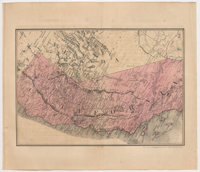
[Map of California and Nevada]
Print $20.00
- Digital $50.00
[Map of California and Nevada]
1869
Size: 9.1 x 10.6 inches
96620
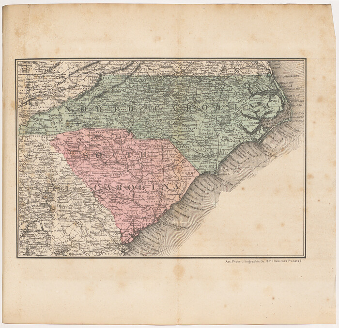
[Map of North Carolina and South Carolina]
Print $20.00
- Digital $50.00
[Map of North Carolina and South Carolina]
1869
Size: 8.9 x 9.2 inches
96621
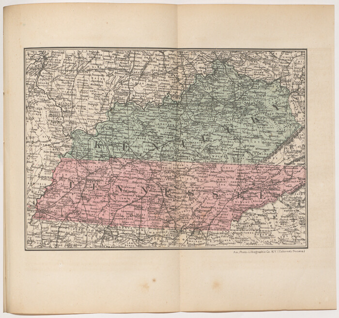
[Map of Kentucky and Tennessee]
Print $20.00
- Digital $50.00
[Map of Kentucky and Tennessee]
1869
Size: 8.9 x 9.5 inches
96623
County and Railroad Map of Texas

Print $20.00
- Digital $50.00
County and Railroad Map of Texas
1871
Size: 16.7 x 15.5 inches
95752
Map of the Houston & Texas Central Railway and connections

Print $20.00
- Digital $50.00
Map of the Houston & Texas Central Railway and connections
1871
Size: 16.6 x 15.4 inches
95753
Map of the N. Orleans, Mobile and Texas Railroad and Connections

Print $20.00
- Digital $50.00
Map of the N. Orleans, Mobile and Texas Railroad and Connections
1871
Size: 8.9 x 11.1 inches
96611
Correct Map of Texas

Print $20.00
- Digital $50.00
Correct Map of Texas
1873
Size: 21.5 x 16.9 inches
95775
Correct Map of Texas

Print $20.00
- Digital $50.00
Correct Map of Texas
1873
Size: 21.3 x 16.9 inches
95776
County and Railroad Map of Texas

Print $20.00
- Digital $50.00
County and Railroad Map of Texas
1875
Size: 17.4 x 16.0 inches
95754
Revised map of the State of Texas

Print $20.00
- Digital $50.00
Revised map of the State of Texas
1876
Size: 19.6 x 19.7 inches
95755
A Geographically Correct County Map of States Traversed by the St. Louis, Iron Mountain & Southern Railway and its Connections

Print $20.00
- Digital $50.00
A Geographically Correct County Map of States Traversed by the St. Louis, Iron Mountain & Southern Railway and its Connections
1876
Size: 18.6 x 15.9 inches
95781
The Great Texas Route via the Beautiful Indian Territory / The Great Kansas Route via the Picturesque Valley of the Neosho

Print $20.00
- Digital $50.00
The Great Texas Route via the Beautiful Indian Territory / The Great Kansas Route via the Picturesque Valley of the Neosho
1876
Size: 12.1 x 17.4 inches
95804
Map of the State of Texas

Print $20.00
- Digital $50.00
Map of the State of Texas
1876
Size: 13.0 x 16.3 inches
95891
Red River County, Texas
Print $20.00
- Digital $50.00
Red River County, Texas
-
Size
22.2 x 17.2 inches
-
Map/Doc
95756
Sectional map of Texas traversed by the Missouri, Kansas & Texas Railway, showing the crops adapted to each section, with the elevation and annual rainfall
Print $20.00
- Digital $50.00
Sectional map of Texas traversed by the Missouri, Kansas & Texas Railway, showing the crops adapted to each section, with the elevation and annual rainfall
-
Size
21.9 x 22.8 inches
-
Map/Doc
95818
Missouri, Kansas, & Texas Ry.
Print $20.00
- Digital $50.00
Missouri, Kansas, & Texas Ry.
-
Size
6.7 x 5.4 inches
-
Map/Doc
96598
Map of the Missouri, Kansas, & Texas Railway and Connecting Lines
Print $20.00
- Digital $50.00
Map of the Missouri, Kansas, & Texas Railway and Connecting Lines
-
Size
11.2 x 17.2 inches
-
Map/Doc
96599
Sectional Map of the Eastern Half of Texas traversed by the Missouri, Kansas & Texas Railway, showing the crops adapted to each section, with the elevation and average annual rainfall
Print $20.00
- Digital $50.00
Sectional Map of the Eastern Half of Texas traversed by the Missouri, Kansas & Texas Railway, showing the crops adapted to each section, with the elevation and average annual rainfall
-
Size
18.3 x 14.7 inches
-
Map/Doc
96602
Three Through Trains for Texas Travelers via Katy Line - Missouri, Kansas and Texas Railway from Chicago, St. Louis, Kansas City and a comprehensive local service reaching all points in Missouri, Kansas, Texas and Indian Territory
Three Through Trains for Texas Travelers via Katy Line - Missouri, Kansas and Texas Railway from Chicago, St. Louis, Kansas City and a comprehensive local service reaching all points in Missouri, Kansas, Texas and Indian Territory
-
Size
9.5 x 6.3 inches
-
Map/Doc
96605
Souvenir of Galveston the Sea Wall City
Souvenir of Galveston the Sea Wall City
-
Size
5.7 x 7.6 inches
-
Map/Doc
97051
Phelps's National Map of the United States, a Travellers Guide. Embracing the principal railroads, canals, steamboat & stage routes, throughout the Union
Print $20.00
- Digital $50.00
Phelps's National Map of the United States, a Travellers Guide. Embracing the principal railroads, canals, steamboat & stage routes, throughout the Union
1849
-
Size
20.9 x 26.3 inches
-
Map/Doc
95901
-
Creation Date
1849
Map of the Southern and South-western States engraved to accompany Appletons' hand book of American travel
Print $20.00
- Digital $50.00
Map of the Southern and South-western States engraved to accompany Appletons' hand book of American travel
1849
-
Size
13.0 x 17.8 inches
-
Map/Doc
95902
-
Creation Date
1849
Geological Map of the route explored by Lieut. A.W. Whipple, Corps of Topl. Engrs. near the Parallel of 35° North Latitude from the Mississippi River to the Pacific Ocean 1853-1854
Print $20.00
- Digital $50.00
Geological Map of the route explored by Lieut. A.W. Whipple, Corps of Topl. Engrs. near the Parallel of 35° North Latitude from the Mississippi River to the Pacific Ocean 1853-1854
1854
-
Size
11.2 x 39.3 inches
-
Map/Doc
95750
-
Creation Date
1854
Geological Map of the route explored by Capt. Jno. Pope, Corps of Topl. Engrs. near the 32nd Parallel of North Latitude from the Red River to the Rio Grande
Print $20.00
- Digital $50.00
Geological Map of the route explored by Capt. Jno. Pope, Corps of Topl. Engrs. near the 32nd Parallel of North Latitude from the Red River to the Rio Grande
1854
-
Size
11.1 x 24.8 inches
-
Map/Doc
95751
-
Creation Date
1854
Dinsmore & Company's New and Complete Map of the Railway System of the United States and Canada compiled from official sources, under the direction of the editor of the "American Railway Guide"
Print $20.00
- Digital $50.00
Dinsmore & Company's New and Complete Map of the Railway System of the United States and Canada compiled from official sources, under the direction of the editor of the "American Railway Guide"
1855
-
Size
16.3 x 20.4 inches
-
Map/Doc
95903
-
Creation Date
1855
Where to Emigrate and Why

Where to Emigrate and Why
1869
-
Size
9.3 x 6.5 inches
-
Map/Doc
96610
-
Creation Date
1869
Map of the United States of America for Goddard's "Where to Emigrate and Why"
Print $20.00
- Digital $50.00
Map of the United States of America for Goddard's "Where to Emigrate and Why"
1869
-
Size
12.4 x 18.8 inches
-
Map/Doc
96619
-
Creation Date
1869
[Map of California and Nevada]
Print $20.00
- Digital $50.00
[Map of California and Nevada]
1869
-
Size
9.1 x 10.6 inches
-
Map/Doc
96620
-
Creation Date
1869
[Map of North Carolina and South Carolina]
Print $20.00
- Digital $50.00
[Map of North Carolina and South Carolina]
1869
-
Size
8.9 x 9.2 inches
-
Map/Doc
96621
-
Creation Date
1869
[Map of Florida]
![96622, [Map of Florida], Cobb Digital Map Collection](https://historictexasmaps.com/wmedia_w700/maps/96622.tif.jpg)
Print $20.00
- Digital $50.00
[Map of Florida]
1869
-
Size
9.0 x 9.6 inches
-
Map/Doc
96622
-
Creation Date
1869
[Map of Kentucky and Tennessee]
Print $20.00
- Digital $50.00
[Map of Kentucky and Tennessee]
1869
-
Size
8.9 x 9.5 inches
-
Map/Doc
96623
-
Creation Date
1869
[Map of Texas]
![96624, [Map of Texas], Cobb Digital Map Collection](https://historictexasmaps.com/wmedia_w700/maps/96624.tif.jpg)
Print $20.00
- Digital $50.00
[Map of Texas]
1869
-
Size
9.9 x 8.8 inches
-
Map/Doc
96624
-
Creation Date
1869
County and Railroad Map of Texas
Print $20.00
- Digital $50.00
County and Railroad Map of Texas
1871
-
Size
16.7 x 15.5 inches
-
Map/Doc
95752
-
Creation Date
1871
Map of the Houston & Texas Central Railway and connections
Print $20.00
- Digital $50.00
Map of the Houston & Texas Central Railway and connections
1871
-
Size
16.6 x 15.4 inches
-
Map/Doc
95753
-
Creation Date
1871
Map of the N. Orleans, Mobile and Texas Railroad and Connections
Print $20.00
- Digital $50.00
Map of the N. Orleans, Mobile and Texas Railroad and Connections
1871
-
Size
8.9 x 11.1 inches
-
Map/Doc
96611
-
Creation Date
1871
Correct Map of Texas
Print $20.00
- Digital $50.00
Correct Map of Texas
1873
-
Size
21.5 x 16.9 inches
-
Map/Doc
95775
-
Creation Date
1873
Correct Map of Texas
Print $20.00
- Digital $50.00
Correct Map of Texas
1873
-
Size
21.3 x 16.9 inches
-
Map/Doc
95776
-
Creation Date
1873
County and Railroad Map of Texas
Print $20.00
- Digital $50.00
County and Railroad Map of Texas
1875
-
Size
17.4 x 16.0 inches
-
Map/Doc
95754
-
Creation Date
1875
Revised map of the State of Texas
Print $20.00
- Digital $50.00
Revised map of the State of Texas
1876
-
Size
19.6 x 19.7 inches
-
Map/Doc
95755
-
Creation Date
1876
A Geographically Correct County Map of States Traversed by the St. Louis, Iron Mountain & Southern Railway and its Connections
Print $20.00
- Digital $50.00
A Geographically Correct County Map of States Traversed by the St. Louis, Iron Mountain & Southern Railway and its Connections
1876
-
Size
18.6 x 15.9 inches
-
Map/Doc
95781
-
Creation Date
1876
The Great Texas Route via the Beautiful Indian Territory / The Great Kansas Route via the Picturesque Valley of the Neosho
Print $20.00
- Digital $50.00
The Great Texas Route via the Beautiful Indian Territory / The Great Kansas Route via the Picturesque Valley of the Neosho
1876
-
Size
12.1 x 17.4 inches
-
Map/Doc
95804
-
Creation Date
1876
Map of the State of Texas
Print $20.00
- Digital $50.00
Map of the State of Texas
1876
-
Size
13.0 x 16.3 inches
-
Map/Doc
95891
-
Creation Date
1876