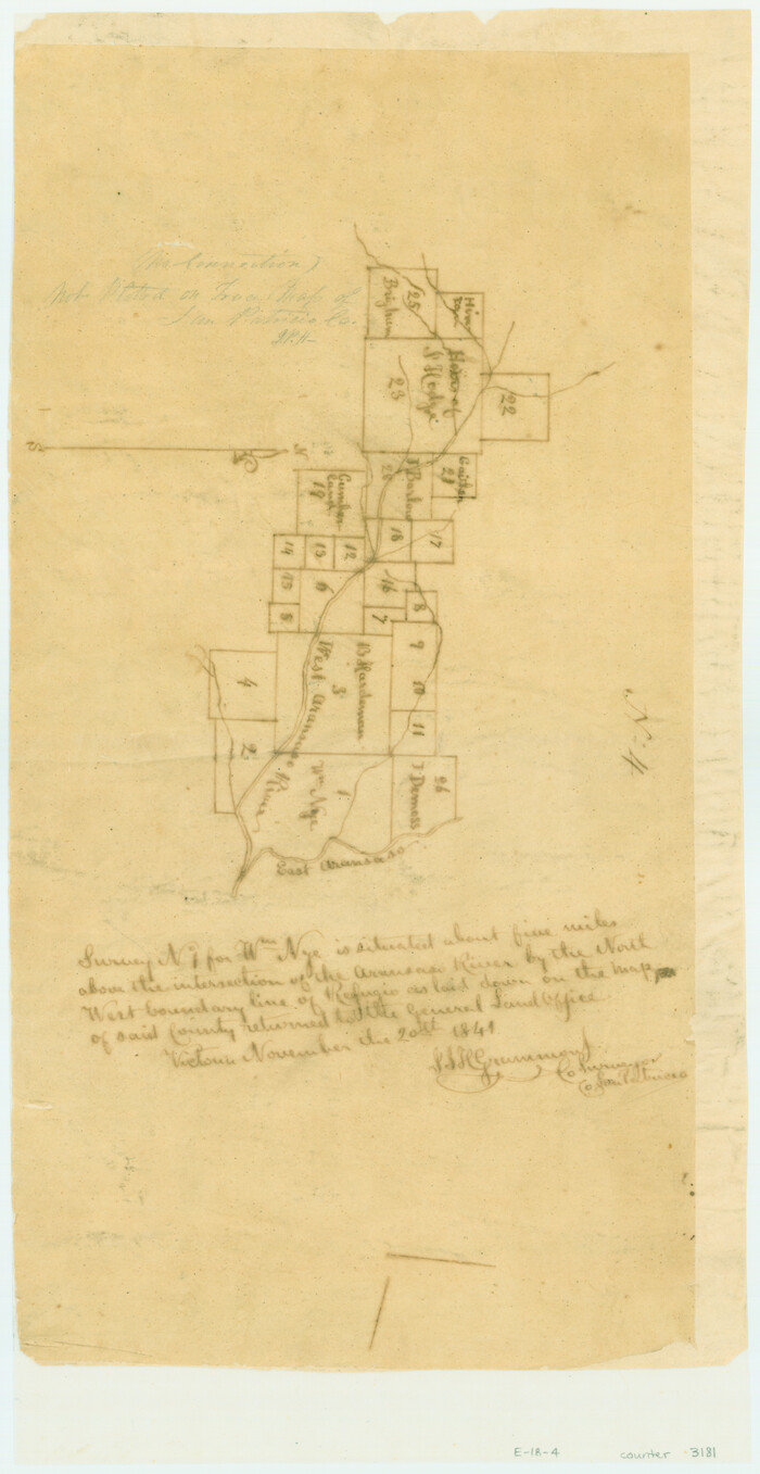
[Surveys in the San Patricio District along the West Aransas River]
Print $2.00
- Digital $50.00
[Surveys in the San Patricio District along the West Aransas River]
1841
Size: 16.1 x 8.3 inches
3181
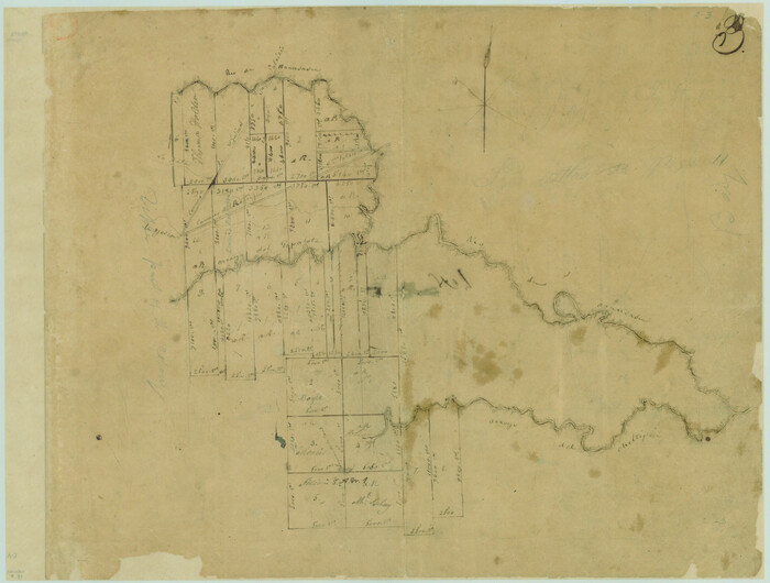
[Surveys in Power and Hewetson's Colony along the Aransas River, shown as Aransasu and Chiltipin Creek]
Print $20.00
- Digital $50.00
[Surveys in Power and Hewetson's Colony along the Aransas River, shown as Aransasu and Chiltipin Creek]
Size: 12.9 x 17.0 inches
31
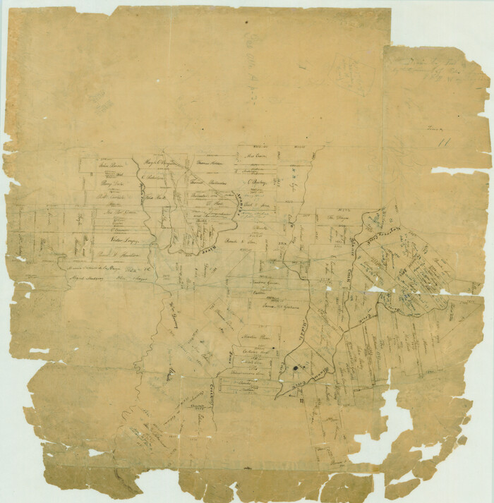
[Surveys in Power and Hewetson's Colony along the Aransas River, Middle Creek, Papalose Creek, and Blanco Creek]
Print $20.00
- Digital $50.00
[Surveys in Power and Hewetson's Colony along the Aransas River, Middle Creek, Papalose Creek, and Blanco Creek]
1830
Size: 21.6 x 21.2 inches
81
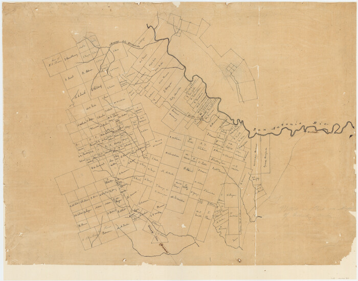
[Surveys in McMullen and McGloin's Colony along the San Antonio River]
Print $20.00
- Digital $50.00
[Surveys in McMullen and McGloin's Colony along the San Antonio River]
1828
Size: 19.3 x 24.5 inches
30
Yowards Ranche, Bee County, Texas

Print $20.00
- Digital $50.00
Yowards Ranche, Bee County, Texas
Size: 13.3 x 12.4 inches
381
Working Sketch, Goliad & Bee Counties

Print $20.00
- Digital $50.00
Working Sketch, Goliad & Bee Counties
1936
Size: 35.0 x 43.1 inches
2453
San Patricio County, Texas

Print $20.00
- Digital $50.00
San Patricio County, Texas
1879
Size: 18.1 x 22.8 inches
611
San Patricio County Sketch File 20

Print $14.00
San Patricio County Sketch File 20
1868
Size: 9.2 x 8.5 inches
36069
Refugio County, Texas

Print $20.00
- Digital $50.00
Refugio County, Texas
1879
Size: 19.9 x 29.0 inches
600
Refugio County Working Sketch 12

Print $40.00
- Digital $50.00
Refugio County Working Sketch 12
1949
Size: 42.6 x 48.2 inches
63521
Refugio County Sketch File 8a

Print $2.00
- Digital $50.00
Refugio County Sketch File 8a
Size: 8.1 x 10.2 inches
35253
Refugio County Sketch File 7

Print $4.00
- Digital $50.00
Refugio County Sketch File 7
1875
Size: 12.1 x 7.6 inches
35251
Refugio County Sketch File 20

Print $8.00
- Digital $50.00
Refugio County Sketch File 20
Size: 14.4 x 8.8 inches
35276
Refugio County Sketch File 16

Print $4.00
- Digital $50.00
Refugio County Sketch File 16
Size: 7.1 x 8.2 inches
35270
Refugio County Sketch File 10

Print $4.00
- Digital $50.00
Refugio County Sketch File 10
Size: 8.2 x 9.4 inches
35258
Nueces County Rolled Sketch GT

Print $20.00
- Digital $50.00
Nueces County Rolled Sketch GT
1924
Size: 24.9 x 38.6 inches
7169
McMullen County Sketch File 44

Print $6.00
- Digital $50.00
McMullen County Sketch File 44
1942
Size: 14.2 x 8.8 inches
31426
Map of Bee County State of Texas

Print $20.00
- Digital $50.00
Map of Bee County State of Texas
1863
Size: 31.1 x 25.3 inches
3286
Map of Bee County

Print $20.00
- Digital $50.00
Map of Bee County
1879
Size: 25.3 x 22.8 inches
3288
Map of Bee County

Print $20.00
- Digital $50.00
Map of Bee County
1879
Size: 25.1 x 22.7 inches
3289
Live Oak County Working Sketch 36

Print $20.00
- Digital $50.00
Live Oak County Working Sketch 36
2008
Size: 33.5 x 35.8 inches
88879
Live Oak County Working Sketch 25

Print $3.00
- Digital $50.00
Live Oak County Working Sketch 25
1980
Size: 16.7 x 10.6 inches
70610
Live Oak County Sketch File 24

Print $20.00
- Digital $50.00
Live Oak County Sketch File 24
1912
Size: 20.0 x 19.6 inches
12010
Live Oak County Sketch File 2

Print $4.00
- Digital $50.00
Live Oak County Sketch File 2
1856
Size: 11.4 x 7.6 inches
30253
Live Oak County Sketch File 19

Print $20.00
- Digital $50.00
Live Oak County Sketch File 19
1879
Size: 24.7 x 18.3 inches
4580
Live Oak County Sketch File 1

Print $4.00
- Digital $50.00
Live Oak County Sketch File 1
1856
Size: 11.5 x 7.8 inches
30251
Live Oak County Rolled Sketch 2

Print $20.00
- Digital $50.00
Live Oak County Rolled Sketch 2
1944
Size: 34.1 x 26.6 inches
6632
Land grants from the state of Tamaulipas in the trans-Nueces

Land grants from the state of Tamaulipas in the trans-Nueces
2009
Size: 11.0 x 8.5 inches
94040
Karnes County Sketch File 8

Print $78.00
- Digital $50.00
Karnes County Sketch File 8
1876
Size: 12.7 x 8.2 inches
28565
[Surveys in the San Patricio District along the West Aransas River]
Print $2.00
- Digital $50.00
[Surveys in the San Patricio District along the West Aransas River]
1841
-
Size
16.1 x 8.3 inches
-
Map/Doc
3181
-
Creation Date
1841
[Surveys in Power and Hewetson's Colony along the Aransas River, shown as Aransasu and Chiltipin Creek]
Print $20.00
- Digital $50.00
[Surveys in Power and Hewetson's Colony along the Aransas River, shown as Aransasu and Chiltipin Creek]
-
Size
12.9 x 17.0 inches
-
Map/Doc
31
[Surveys in Power and Hewetson's Colony along the Aransas River, Middle Creek, Papalose Creek, and Blanco Creek]
Print $20.00
- Digital $50.00
[Surveys in Power and Hewetson's Colony along the Aransas River, Middle Creek, Papalose Creek, and Blanco Creek]
1830
-
Size
21.6 x 21.2 inches
-
Map/Doc
81
-
Creation Date
1830
[Surveys in McMullen and McGloin's Colony along the San Antonio River]
Print $20.00
- Digital $50.00
[Surveys in McMullen and McGloin's Colony along the San Antonio River]
1828
-
Size
19.3 x 24.5 inches
-
Map/Doc
30
-
Creation Date
1828
Yowards Ranche, Bee County, Texas
Print $20.00
- Digital $50.00
Yowards Ranche, Bee County, Texas
-
Size
13.3 x 12.4 inches
-
Map/Doc
381
Working Sketch, Goliad & Bee Counties
Print $20.00
- Digital $50.00
Working Sketch, Goliad & Bee Counties
1936
-
Size
35.0 x 43.1 inches
-
Map/Doc
2453
-
Creation Date
1936
San Patricio County, Texas
Print $20.00
- Digital $50.00
San Patricio County, Texas
1879
-
Size
18.1 x 22.8 inches
-
Map/Doc
611
-
Creation Date
1879
San Patricio County Sketch File 20
Print $14.00
San Patricio County Sketch File 20
1868
-
Size
9.2 x 8.5 inches
-
Map/Doc
36069
-
Creation Date
1868
Refugio County, Texas
Print $20.00
- Digital $50.00
Refugio County, Texas
1879
-
Size
19.9 x 29.0 inches
-
Map/Doc
600
-
Creation Date
1879
Refugio County Working Sketch 12
Print $40.00
- Digital $50.00
Refugio County Working Sketch 12
1949
-
Size
42.6 x 48.2 inches
-
Map/Doc
63521
-
Creation Date
1949
Refugio County Sketch File 8a
Print $2.00
- Digital $50.00
Refugio County Sketch File 8a
-
Size
8.1 x 10.2 inches
-
Map/Doc
35253
Refugio County Sketch File 7
Print $4.00
- Digital $50.00
Refugio County Sketch File 7
1875
-
Size
12.1 x 7.6 inches
-
Map/Doc
35251
-
Creation Date
1875
Refugio County Sketch File 20
Print $8.00
- Digital $50.00
Refugio County Sketch File 20
-
Size
14.4 x 8.8 inches
-
Map/Doc
35276
Refugio County Sketch File 16
Print $4.00
- Digital $50.00
Refugio County Sketch File 16
-
Size
7.1 x 8.2 inches
-
Map/Doc
35270
Refugio County Sketch File 10
Print $4.00
- Digital $50.00
Refugio County Sketch File 10
-
Size
8.2 x 9.4 inches
-
Map/Doc
35258
Nueces County Rolled Sketch GT
Print $20.00
- Digital $50.00
Nueces County Rolled Sketch GT
1924
-
Size
24.9 x 38.6 inches
-
Map/Doc
7169
-
Creation Date
1924
McMullen County Sketch File 44
Print $6.00
- Digital $50.00
McMullen County Sketch File 44
1942
-
Size
14.2 x 8.8 inches
-
Map/Doc
31426
-
Creation Date
1942
Map of Bee County State of Texas
Print $20.00
- Digital $50.00
Map of Bee County State of Texas
1863
-
Size
31.1 x 25.3 inches
-
Map/Doc
3286
-
Creation Date
1863
Map of Bee County
Print $20.00
- Digital $50.00
Map of Bee County
1879
-
Size
25.3 x 22.8 inches
-
Map/Doc
3288
-
Creation Date
1879
Map of Bee County
Print $20.00
- Digital $50.00
Map of Bee County
1879
-
Size
25.1 x 22.7 inches
-
Map/Doc
3289
-
Creation Date
1879
Map of Bee County

Print $20.00
Map of Bee County
1879
-
Size
28.7 x 24.7 inches
-
Map/Doc
88904
-
Creation Date
1879
Live Oak County Working Sketch 36
Print $20.00
- Digital $50.00
Live Oak County Working Sketch 36
2008
-
Size
33.5 x 35.8 inches
-
Map/Doc
88879
-
Creation Date
2008
Live Oak County Working Sketch 25
Print $3.00
- Digital $50.00
Live Oak County Working Sketch 25
1980
-
Size
16.7 x 10.6 inches
-
Map/Doc
70610
-
Creation Date
1980
Live Oak County Sketch File 24
Print $20.00
- Digital $50.00
Live Oak County Sketch File 24
1912
-
Size
20.0 x 19.6 inches
-
Map/Doc
12010
-
Creation Date
1912
Live Oak County Sketch File 2
Print $4.00
- Digital $50.00
Live Oak County Sketch File 2
1856
-
Size
11.4 x 7.6 inches
-
Map/Doc
30253
-
Creation Date
1856
Live Oak County Sketch File 19
Print $20.00
- Digital $50.00
Live Oak County Sketch File 19
1879
-
Size
24.7 x 18.3 inches
-
Map/Doc
4580
-
Creation Date
1879
Live Oak County Sketch File 1
Print $4.00
- Digital $50.00
Live Oak County Sketch File 1
1856
-
Size
11.5 x 7.8 inches
-
Map/Doc
30251
-
Creation Date
1856
Live Oak County Rolled Sketch 2
Print $20.00
- Digital $50.00
Live Oak County Rolled Sketch 2
1944
-
Size
34.1 x 26.6 inches
-
Map/Doc
6632
-
Creation Date
1944
Land grants from the state of Tamaulipas in the trans-Nueces
Land grants from the state of Tamaulipas in the trans-Nueces
2009
-
Size
11.0 x 8.5 inches
-
Map/Doc
94040
-
Creation Date
2009
Karnes County Sketch File 8
Print $78.00
- Digital $50.00
Karnes County Sketch File 8
1876
-
Size
12.7 x 8.2 inches
-
Map/Doc
28565
-
Creation Date
1876