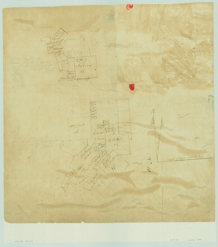
[Surveys on the San Marcos River]
Print $20.00
- Digital $50.00
[Surveys on the San Marcos River]
Size: 14.1 x 12.4 inches
149
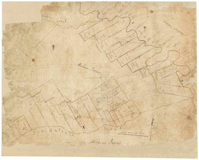
[Surveys in Milam's Colony between the Colorado River and northwest of the San Antonio Road]
Print $20.00
- Digital $50.00
[Surveys in Milam's Colony between the Colorado River and northwest of the San Antonio Road]
Size: 22.0 x 27.4 inches
29
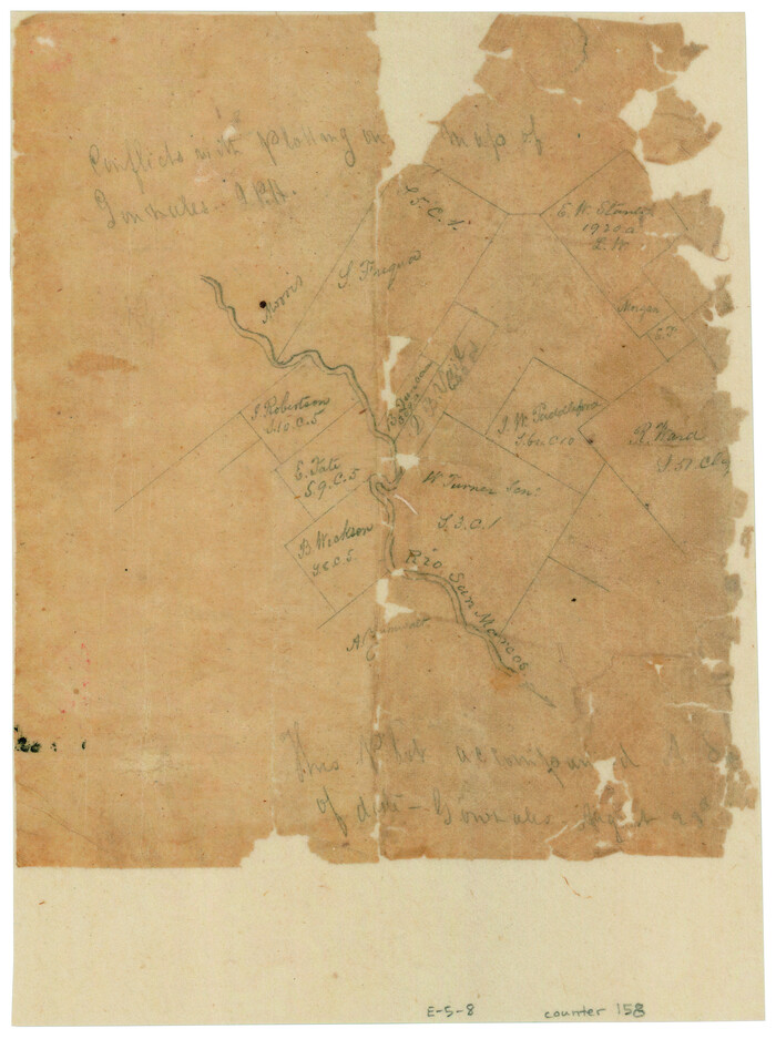
[Surveys along the San Marcos River]
Print $2.00
- Digital $50.00
[Surveys along the San Marcos River]
Size: 7.7 x 5.8 inches
158
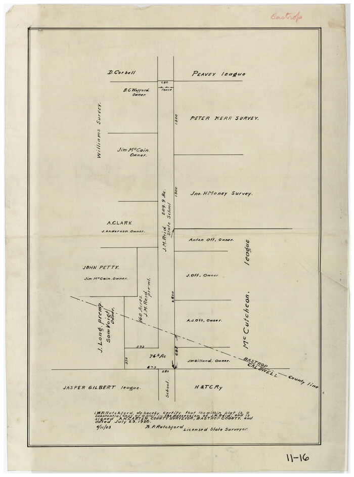
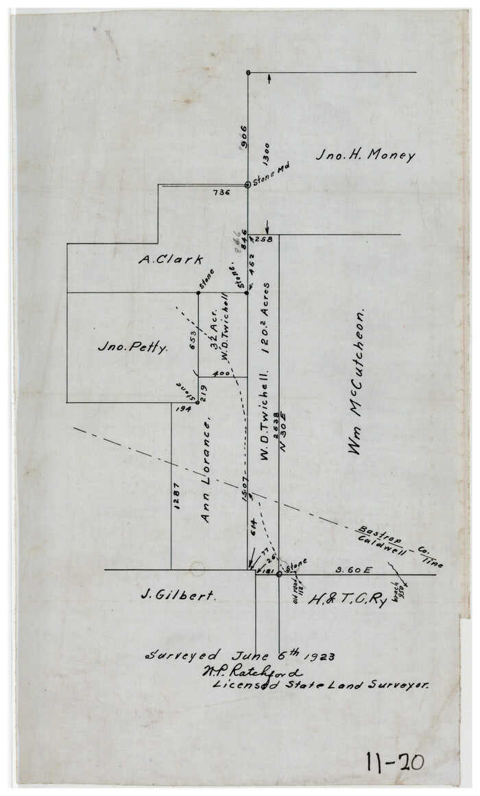
[Subdivision surveys of the McCutcheon League near the Bastrop-Caldwell County Line]
Print $20.00
- Digital $50.00
[Subdivision surveys of the McCutcheon League near the Bastrop-Caldwell County Line]
1923
Size: 12.5 x 16.9 inches
90148
[Sketch showing vicinity of Wm. McCutcheon League near the Bastrop-Caldwell County Line]
Print $2.00
- Digital $50.00
[Sketch showing vicinity of Wm. McCutcheon League near the Bastrop-Caldwell County Line]
1923
Size: 7.7 x 12.9 inches
90144
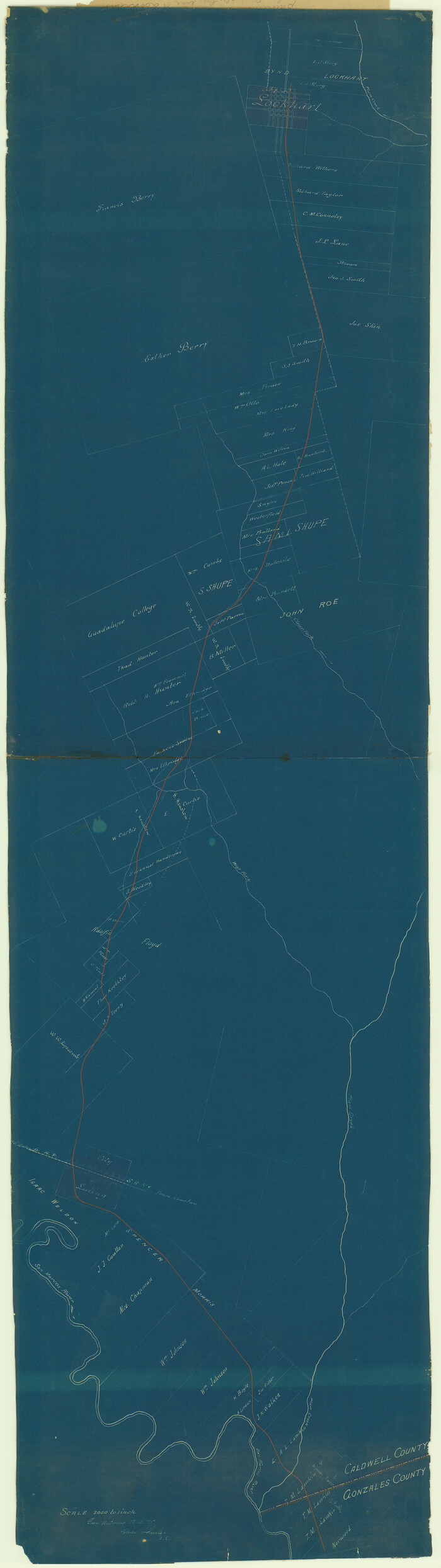
[San Antonio & Aransas Pass Ry. from Lockhart to Caldwell-Gonzales County line]
Print $40.00
- Digital $50.00
[San Antonio & Aransas Pass Ry. from Lockhart to Caldwell-Gonzales County line]
1895
Size: 53.6 x 15.1 inches
64259
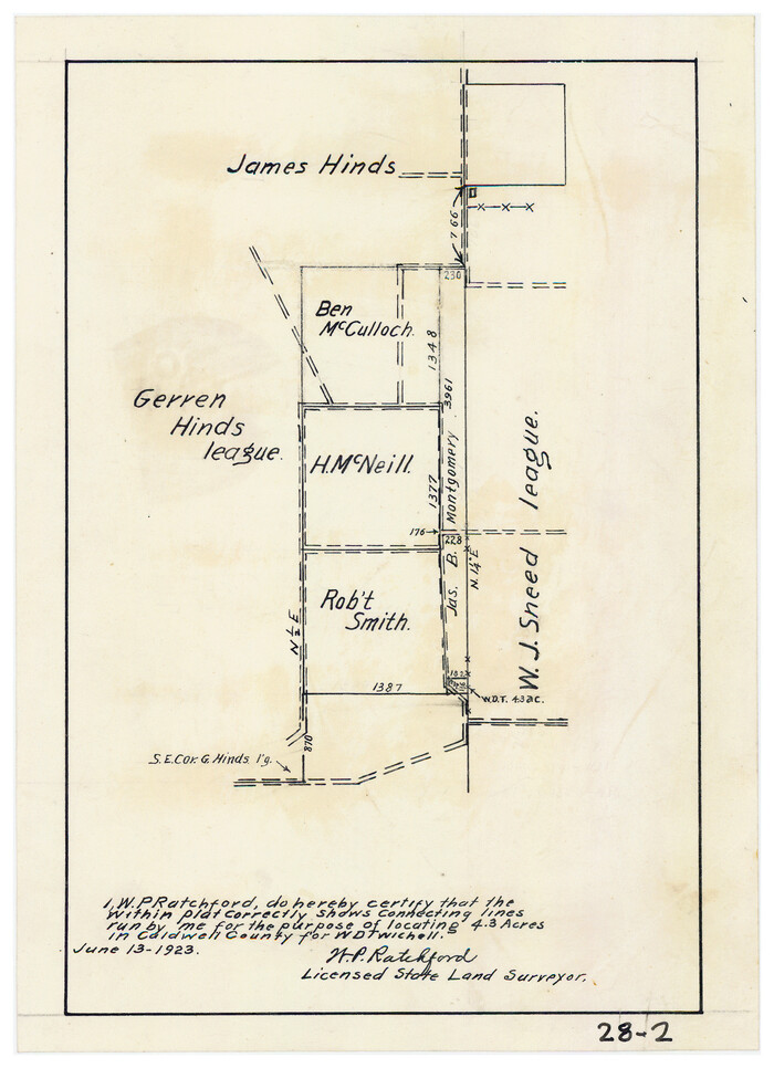
[Plat showing connecting lines for the purpose of locating 4.3 acres in Caldwell County]
Print $2.00
- Digital $50.00
[Plat showing connecting lines for the purpose of locating 4.3 acres in Caldwell County]
1923
Size: 7.4 x 10.2 inches
90220
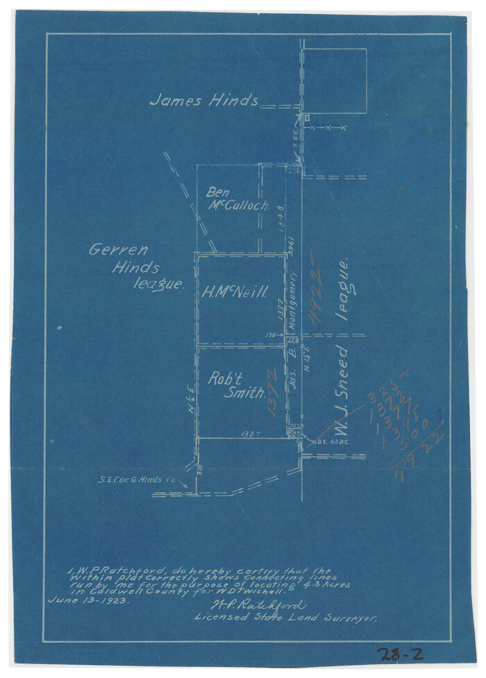
[Plat showing connecting lines for the purpose of locating 4.3 acres in Caldwell County]
Print $2.00
- Digital $50.00
[Plat showing connecting lines for the purpose of locating 4.3 acres in Caldwell County]
1923
Size: 7.0 x 10.0 inches
90221
[Plat of the Town of Lockhart]

Print $20.00
- Digital $50.00
[Plat of the Town of Lockhart]
Size: 19.5 x 25.0 inches
82534
[Gonzales District]
Print $20.00
- Digital $50.00
[Gonzales District]
1840
Size: 42.8 x 37.0 inches
16837
Working Sketch in Caldwell County

Print $20.00
- Digital $50.00
Working Sketch in Caldwell County
1922
Size: 41.1 x 44.4 inches
89722
Working Sketch in Caldwell County

Print $20.00
- Digital $50.00
Working Sketch in Caldwell County
1922
Size: 40.2 x 43.3 inches
93035
Water-Shed of the Colorado River

Print $40.00
- Digital $50.00
Water-Shed of the Colorado River
1925
Size: 37.1 x 79.8 inches
65261
Travis County Working Sketch 53

Print $40.00
- Digital $50.00
Travis County Working Sketch 53
1964
Size: 42.7 x 53.0 inches
69437
Travis County Sketch File ABC

Print $20.00
- Digital $50.00
Travis County Sketch File ABC
Size: 23.8 x 19.0 inches
12480
Surveys on the lines [?] of Plum Creek
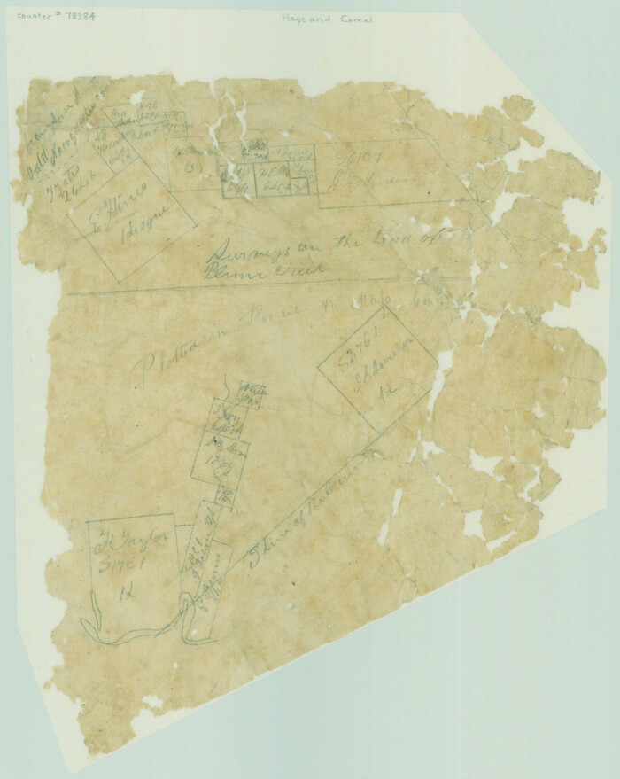
Print $2.00
- Digital $50.00
Surveys on the lines [?] of Plum Creek
Size: 10.5 x 8.4 inches
78384
Right of Way & Track Map San Antonio & Aransas Pass Railway Co.

Print $40.00
- Digital $50.00
Right of Way & Track Map San Antonio & Aransas Pass Railway Co.
1919
Size: 25.3 x 56.5 inches
64024
Right of Way & Track Map San Antonio & Aransas Pass Railway Co.

Print $40.00
- Digital $50.00
Right of Way & Track Map San Antonio & Aransas Pass Railway Co.
1919
Size: 25.6 x 57.0 inches
64025
Right of Way & Track Map San Antonio & Aransas Pass Railway Co.

Print $40.00
- Digital $50.00
Right of Way & Track Map San Antonio & Aransas Pass Railway Co.
1919
Size: 25.1 x 56.7 inches
64026
Right of Way & Track Map San Antonio & Aransas Pass Railway Co.

Print $40.00
- Digital $50.00
Right of Way & Track Map San Antonio & Aransas Pass Railway Co.
1919
Size: 25.8 x 57.1 inches
64027
Map of Lockhart, Caldwell Co., Texas

Print $20.00
- Digital $50.00
Map of Lockhart, Caldwell Co., Texas
1907
Size: 30.5 x 38.9 inches
4461
Map of Kyle, Lockhart & Southern Ry.

Print $40.00
- Digital $50.00
Map of Kyle, Lockhart & Southern Ry.
1882
Size: 14.5 x 94.9 inches
64285
Map of Caldwell County, Texas

Print $20.00
Map of Caldwell County, Texas
1879
Size: 17.4 x 21.5 inches
88914
Map of Caldwell County, Texas

Print $20.00
Map of Caldwell County, Texas
1880
Size: 18.7 x 22.0 inches
88915
Map of Caldwell County, Land District since August 1st. 1859; Originally the part north, east of the line designated Bastrop - the balance, Gonzales Land District

Print $20.00
- Digital $50.00
Map of Caldwell County, Land District since August 1st. 1859; Originally the part north, east of the line designated Bastrop - the balance, Gonzales Land District
1861
Size: 19.9 x 23.0 inches
3355
Map of Caldwell County

Print $20.00
- Digital $50.00
Map of Caldwell County
1871
Size: 17.2 x 19.8 inches
3357
Map of Caldwell County

Print $20.00
- Digital $50.00
Map of Caldwell County
1871
Size: 16.9 x 19.8 inches
4590
Map of Caldwell County

Print $20.00
- Digital $50.00
Map of Caldwell County
1871
Size: 16.9 x 19.9 inches
4591
Map of Caldwell Co.

Print $40.00
- Digital $50.00
Map of Caldwell Co.
1917
Size: 48.4 x 43.0 inches
89748
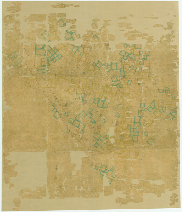
Hays County Sketch File 28

Print $20.00
- Digital $50.00
Hays County Sketch File 28
1912
Size: 26.0 x 20.0 inches
11750
[Surveys on the San Marcos River]
Print $20.00
- Digital $50.00
[Surveys on the San Marcos River]
-
Size
14.1 x 12.4 inches
-
Map/Doc
149
[Surveys in Milam's Colony between the Colorado River and northwest of the San Antonio Road]
Print $20.00
- Digital $50.00
[Surveys in Milam's Colony between the Colorado River and northwest of the San Antonio Road]
-
Size
22.0 x 27.4 inches
-
Map/Doc
29
[Surveys along the San Marcos River]
Print $2.00
- Digital $50.00
[Surveys along the San Marcos River]
-
Size
7.7 x 5.8 inches
-
Map/Doc
158
[Subdivision surveys of the McCutcheon League near the Bastrop-Caldwell County Line]
Print $20.00
- Digital $50.00
[Subdivision surveys of the McCutcheon League near the Bastrop-Caldwell County Line]
1923
-
Size
12.5 x 16.9 inches
-
Map/Doc
90148
-
Creation Date
1923
[Sketch showing vicinity of Wm. McCutcheon League near the Bastrop-Caldwell County Line]
Print $2.00
- Digital $50.00
[Sketch showing vicinity of Wm. McCutcheon League near the Bastrop-Caldwell County Line]
1923
-
Size
7.7 x 12.9 inches
-
Map/Doc
90144
-
Creation Date
1923
[San Antonio & Aransas Pass Ry. from Lockhart to Caldwell-Gonzales County line]
Print $40.00
- Digital $50.00
[San Antonio & Aransas Pass Ry. from Lockhart to Caldwell-Gonzales County line]
1895
-
Size
53.6 x 15.1 inches
-
Map/Doc
64259
-
Creation Date
1895
[Plat showing connecting lines for the purpose of locating 4.3 acres in Caldwell County]
Print $2.00
- Digital $50.00
[Plat showing connecting lines for the purpose of locating 4.3 acres in Caldwell County]
1923
-
Size
7.4 x 10.2 inches
-
Map/Doc
90220
-
Creation Date
1923
[Plat showing connecting lines for the purpose of locating 4.3 acres in Caldwell County]
Print $2.00
- Digital $50.00
[Plat showing connecting lines for the purpose of locating 4.3 acres in Caldwell County]
1923
-
Size
7.0 x 10.0 inches
-
Map/Doc
90221
-
Creation Date
1923
[Plat of the Town of Lockhart]
Print $20.00
- Digital $50.00
[Plat of the Town of Lockhart]
-
Size
19.5 x 25.0 inches
-
Map/Doc
82534
[Gonzales District]
Print $20.00
- Digital $50.00
[Gonzales District]
1840
-
Size
42.8 x 37.0 inches
-
Map/Doc
16837
-
Creation Date
1840
Working Sketch in Caldwell County
Print $20.00
- Digital $50.00
Working Sketch in Caldwell County
1922
-
Size
41.1 x 44.4 inches
-
Map/Doc
89722
-
Creation Date
1922
Working Sketch in Caldwell County
Print $20.00
- Digital $50.00
Working Sketch in Caldwell County
1922
-
Size
40.2 x 43.3 inches
-
Map/Doc
93035
-
Creation Date
1922
Water-Shed of the Colorado River
Print $40.00
- Digital $50.00
Water-Shed of the Colorado River
1925
-
Size
37.1 x 79.8 inches
-
Map/Doc
65261
-
Creation Date
1925
Travis County Working Sketch 53
Print $40.00
- Digital $50.00
Travis County Working Sketch 53
1964
-
Size
42.7 x 53.0 inches
-
Map/Doc
69437
-
Creation Date
1964
Travis County Sketch File ABC
Print $20.00
- Digital $50.00
Travis County Sketch File ABC
-
Size
23.8 x 19.0 inches
-
Map/Doc
12480
Surveys on the lines [?] of Plum Creek
Print $2.00
- Digital $50.00
Surveys on the lines [?] of Plum Creek
-
Size
10.5 x 8.4 inches
-
Map/Doc
78384
Right of Way & Track Map San Antonio & Aransas Pass Railway Co.
Print $40.00
- Digital $50.00
Right of Way & Track Map San Antonio & Aransas Pass Railway Co.
1919
-
Size
25.3 x 56.5 inches
-
Map/Doc
64024
-
Creation Date
1919
Right of Way & Track Map San Antonio & Aransas Pass Railway Co.
Print $40.00
- Digital $50.00
Right of Way & Track Map San Antonio & Aransas Pass Railway Co.
1919
-
Size
25.6 x 57.0 inches
-
Map/Doc
64025
-
Creation Date
1919
Right of Way & Track Map San Antonio & Aransas Pass Railway Co.
Print $40.00
- Digital $50.00
Right of Way & Track Map San Antonio & Aransas Pass Railway Co.
1919
-
Size
25.1 x 56.7 inches
-
Map/Doc
64026
-
Creation Date
1919
Right of Way & Track Map San Antonio & Aransas Pass Railway Co.
Print $40.00
- Digital $50.00
Right of Way & Track Map San Antonio & Aransas Pass Railway Co.
1919
-
Size
25.8 x 57.1 inches
-
Map/Doc
64027
-
Creation Date
1919
Map of Lockhart, Caldwell Co., Texas
Print $20.00
- Digital $50.00
Map of Lockhart, Caldwell Co., Texas
1907
-
Size
30.5 x 38.9 inches
-
Map/Doc
4461
-
Creation Date
1907
Map of Kyle, Lockhart & Southern Ry.
Print $40.00
- Digital $50.00
Map of Kyle, Lockhart & Southern Ry.
1882
-
Size
14.5 x 94.9 inches
-
Map/Doc
64285
-
Creation Date
1882
Map of Caldwell County, Texas
Print $20.00
Map of Caldwell County, Texas
1879
-
Size
17.4 x 21.5 inches
-
Map/Doc
88914
-
Creation Date
1879
Map of Caldwell County, Texas
Print $20.00
Map of Caldwell County, Texas
1880
-
Size
18.7 x 22.0 inches
-
Map/Doc
88915
-
Creation Date
1880
Map of Caldwell County, Land District since August 1st. 1859; Originally the part north, east of the line designated Bastrop - the balance, Gonzales Land District
Print $20.00
- Digital $50.00
Map of Caldwell County, Land District since August 1st. 1859; Originally the part north, east of the line designated Bastrop - the balance, Gonzales Land District
1861
-
Size
19.9 x 23.0 inches
-
Map/Doc
3355
-
Creation Date
1861
Map of Caldwell County
Print $20.00
- Digital $50.00
Map of Caldwell County
1871
-
Size
17.2 x 19.8 inches
-
Map/Doc
3357
-
Creation Date
1871
Map of Caldwell County
Print $20.00
- Digital $50.00
Map of Caldwell County
1871
-
Size
16.9 x 19.8 inches
-
Map/Doc
4590
-
Creation Date
1871
Map of Caldwell County
Print $20.00
- Digital $50.00
Map of Caldwell County
1871
-
Size
16.9 x 19.9 inches
-
Map/Doc
4591
-
Creation Date
1871
Map of Caldwell Co.
Print $40.00
- Digital $50.00
Map of Caldwell Co.
1917
-
Size
48.4 x 43.0 inches
-
Map/Doc
89748
-
Creation Date
1917
Hays County Sketch File 28
Print $20.00
- Digital $50.00
Hays County Sketch File 28
1912
-
Size
26.0 x 20.0 inches
-
Map/Doc
11750
-
Creation Date
1912