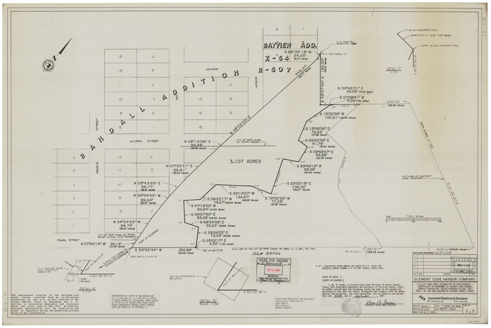
[Plat and field notes of 3.107 acre tract for Clement Cove Harbor Company]
Print $20.00
- Digital $50.00
[Plat and field notes of 3.107 acre tract for Clement Cove Harbor Company]
1987
Size: 24.2 x 36.5 inches
60397
[Plat and field notes of 3.107 acre tract for Clement Cove Harbor Company]

Print $2.00
- Digital $50.00
[Plat and field notes of 3.107 acre tract for Clement Cove Harbor Company]
1987
Size: 13.7 x 8.5 inches
60398
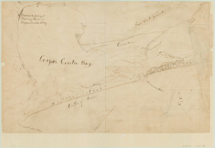
[Aransas and Corpus Christi Bays]
Print $3.00
- Digital $50.00
[Aransas and Corpus Christi Bays]
1839
Size: 11.4 x 16.5 inches
140
Topographical Map of the country between San Antonio & Colorado Rivers in the State of Texas.

Print $40.00
Topographical Map of the country between San Antonio & Colorado Rivers in the State of Texas.
1864
Size: 53.3 x 69.2 inches
88604
The Coast & Bays of Western Texas

Print $20.00
- Digital $50.00
The Coast & Bays of Western Texas
1857
Size: 18.2 x 23.9 inches
73424
Texas, San Antonio Bay, Panther Point

Print $40.00
- Digital $50.00
Texas, San Antonio Bay, Panther Point
1934
Size: 33.2 x 48.3 inches
69995
Texas, San Antonio Bay, Hynes Bay

Print $40.00
- Digital $50.00
Texas, San Antonio Bay, Hynes Bay
1934
Size: 33.0 x 48.9 inches
69998
Texas, San Antonio Bay, Guadalupe Bay

Print $40.00
- Digital $50.00
Texas, San Antonio Bay, Guadalupe Bay
1934
Size: 28.8 x 48.4 inches
69999
Texas, Matagorda Bay, Vicinity of Carancahua Bay

Print $40.00
- Digital $50.00
Texas, Matagorda Bay, Vicinity of Carancahua Bay
1933
Size: 30.3 x 48.2 inches
69989
Texas, Matagorda Bay, Port O'Connor to Gallinipper Point

Print $40.00
- Digital $50.00
Texas, Matagorda Bay, Port O'Connor to Gallinipper Point
1933
Size: 31.1 x 48.6 inches
69985
Texas, Intracoastal Waterway, Ayres Bay to Aransas Bay

Print $40.00
- Digital $50.00
Texas, Intracoastal Waterway, Ayres Bay to Aransas Bay
1934
Size: 33.2 x 48.5 inches
69997
Texas, Espiritu Santo Bay

Print $40.00
- Digital $50.00
Texas, Espiritu Santo Bay
1934
Size: 31.7 x 48.2 inches
69996
Texas Intracoastal Waterway, Aransas Bay to Aransas Pass

Print $20.00
- Digital $50.00
Texas Intracoastal Waterway, Aransas Bay to Aransas Pass
1957
Size: 27.5 x 39.1 inches
73436
Texas Intracoastal Waterway, Aransas Bay to Aransas Pass

Print $20.00
- Digital $50.00
Texas Intracoastal Waterway, Aransas Bay to Aransas Pass
1962
Size: 26.8 x 38.7 inches
73438
Texas Intracoastal Waterway - Port O'Connor to San Antonio Bay, Including Pass Cavallo

Print $20.00
- Digital $50.00
Texas Intracoastal Waterway - Port O'Connor to San Antonio Bay, Including Pass Cavallo
1957
Size: 27.3 x 38.9 inches
73371
Texas Intracoastal Waterway - Port O'Connor to San Antonio Bay, Including Pass Cavallo

Print $20.00
- Digital $50.00
Texas Intracoastal Waterway - Port O'Connor to San Antonio Bay, Including Pass Cavallo
1957
Size: 28.1 x 40.0 inches
73372
Texas Intracoastal Waterway - Port O'Connor to San Antonio Bay, Including Pass Cavallo

Print $20.00
- Digital $50.00
Texas Intracoastal Waterway - Port O'Connor to San Antonio Bay, Including Pass Cavallo
1961
Size: 26.5 x 38.7 inches
73373
Texas Intracoastal Waterway - Port O'Connor to San Antonio Bay, Including Pass Cavallo

Print $20.00
- Digital $50.00
Texas Intracoastal Waterway - Port O'Connor to San Antonio Bay, Including Pass Cavallo
1961
Size: 26.4 x 38.8 inches
73374
Texas Intracoastal Waterway - Matagorda Bay, Cedar Lakes to Oyster Lake

Digital $50.00
Texas Intracoastal Waterway - Matagorda Bay, Cedar Lakes to Oyster Lake
1956
Size: 27.5 x 38.6 inches
73368
Texas Intracoastal Waterway - Matagorda Bay, Cedar Lakes to Oyster Lake

Print $20.00
- Digital $50.00
Texas Intracoastal Waterway - Matagorda Bay, Cedar Lakes to Oyster Lake
1960
Size: 27.1 x 38.9 inches
73370
Texas Gulf Coast, from the Sabine River to the Rio Grande as Subdivided for Mineral Development; Matagorda, Calhoun and Aransas Counties

Print $40.00
- Digital $50.00
Texas Gulf Coast, from the Sabine River to the Rio Grande as Subdivided for Mineral Development; Matagorda, Calhoun and Aransas Counties
1976
Size: 43.0 x 90.9 inches
1939
Texas Gulf Coast Map from the Sabine River to the Rio Grande as subdivided for mineral development

Print $40.00
- Digital $50.00
Texas Gulf Coast Map from the Sabine River to the Rio Grande as subdivided for mineral development
Size: 46.0 x 91.3 inches
2901
Sketch of Surveys on Caranchua and Tres Palacious Bayous, Jackson Co.

Print $2.00
- Digital $50.00
Sketch of Surveys on Caranchua and Tres Palacious Bayous, Jackson Co.
Size: 7.9 x 7.8 inches
69743
San Antonio Bay and Vicinity in Aransas and Calhoun Counties, showing Subdivsion for Mineral Development

Print $40.00
- Digital $50.00
San Antonio Bay and Vicinity in Aransas and Calhoun Counties, showing Subdivsion for Mineral Development
1948
Size: 37.0 x 74.5 inches
1912
Revised map of Matagorda Bay and vicinity in Matagorda and Calhoun Counties showing subdivision for mineral development

Print $40.00
- Digital $50.00
Revised map of Matagorda Bay and vicinity in Matagorda and Calhoun Counties showing subdivision for mineral development
1941
Size: 43.4 x 56.6 inches
3098
Revised Map of Matagorda Bay and Vicinity in Matagorda and Calhoun Counties showing subdivision for mineral development

Print $40.00
- Digital $50.00
Revised Map of Matagorda Bay and Vicinity in Matagorda and Calhoun Counties showing subdivision for mineral development
1941
Size: 44.3 x 60.0 inches
2933
Proposed bombing and machine gun restricted areas along Gulf of Mexico from San Luis Pass to Aransas Pass

Print $20.00
- Digital $50.00
Proposed bombing and machine gun restricted areas along Gulf of Mexico from San Luis Pass to Aransas Pass
1941
Size: 11.1 x 24.1 inches
3024
Portion of States submerged area in Lavaca Bay, Calhoun County, Texas

Print $20.00
- Digital $50.00
Portion of States submerged area in Lavaca Bay, Calhoun County, Texas
1921
Size: 23.0 x 27.0 inches
2940
Plan of the City of Indianola, Texas

Print $40.00
- Digital $50.00
Plan of the City of Indianola, Texas
1868
Size: 37.5 x 55.3 inches
4835
[Victoria District]
![1945, [Victoria District], General Map Collection](https://historictexasmaps.com/wmedia_w700/maps/1945.tif.jpg)
Print $20.00
- Digital $50.00
[Victoria District]
-
Size
34.8 x 25.6 inches
-
Map/Doc
1945
[Plat and field notes of 3.107 acre tract for Clement Cove Harbor Company]
Print $20.00
- Digital $50.00
[Plat and field notes of 3.107 acre tract for Clement Cove Harbor Company]
1987
-
Size
24.2 x 36.5 inches
-
Map/Doc
60397
-
Creation Date
1987
[Plat and field notes of 3.107 acre tract for Clement Cove Harbor Company]
Print $2.00
- Digital $50.00
[Plat and field notes of 3.107 acre tract for Clement Cove Harbor Company]
1987
-
Size
13.7 x 8.5 inches
-
Map/Doc
60398
-
Creation Date
1987
[Aransas and Corpus Christi Bays]
Print $3.00
- Digital $50.00
[Aransas and Corpus Christi Bays]
1839
-
Size
11.4 x 16.5 inches
-
Map/Doc
140
-
Creation Date
1839
Topographical Map of the country between San Antonio & Colorado Rivers in the State of Texas.
Print $40.00
Topographical Map of the country between San Antonio & Colorado Rivers in the State of Texas.
1864
-
Size
53.3 x 69.2 inches
-
Map/Doc
88604
-
Creation Date
1864
The Coast & Bays of Western Texas
Print $20.00
- Digital $50.00
The Coast & Bays of Western Texas
1857
-
Size
18.2 x 23.9 inches
-
Map/Doc
73424
-
Creation Date
1857
Texas, San Antonio Bay, Panther Point
Print $40.00
- Digital $50.00
Texas, San Antonio Bay, Panther Point
1934
-
Size
33.2 x 48.3 inches
-
Map/Doc
69995
-
Creation Date
1934
Texas, San Antonio Bay, Hynes Bay
Print $40.00
- Digital $50.00
Texas, San Antonio Bay, Hynes Bay
1934
-
Size
33.0 x 48.9 inches
-
Map/Doc
69998
-
Creation Date
1934
Texas, San Antonio Bay, Guadalupe Bay
Print $40.00
- Digital $50.00
Texas, San Antonio Bay, Guadalupe Bay
1934
-
Size
28.8 x 48.4 inches
-
Map/Doc
69999
-
Creation Date
1934
Texas, Matagorda Bay, Vicinity of Carancahua Bay
Print $40.00
- Digital $50.00
Texas, Matagorda Bay, Vicinity of Carancahua Bay
1933
-
Size
30.3 x 48.2 inches
-
Map/Doc
69989
-
Creation Date
1933
Texas, Matagorda Bay, Port O'Connor to Gallinipper Point
Print $40.00
- Digital $50.00
Texas, Matagorda Bay, Port O'Connor to Gallinipper Point
1933
-
Size
31.1 x 48.6 inches
-
Map/Doc
69985
-
Creation Date
1933
Texas, Intracoastal Waterway, Ayres Bay to Aransas Bay
Print $40.00
- Digital $50.00
Texas, Intracoastal Waterway, Ayres Bay to Aransas Bay
1934
-
Size
33.2 x 48.5 inches
-
Map/Doc
69997
-
Creation Date
1934
Texas, Espiritu Santo Bay
Print $40.00
- Digital $50.00
Texas, Espiritu Santo Bay
1934
-
Size
31.7 x 48.2 inches
-
Map/Doc
69996
-
Creation Date
1934
Texas Intracoastal Waterway, Aransas Bay to Aransas Pass
Print $20.00
- Digital $50.00
Texas Intracoastal Waterway, Aransas Bay to Aransas Pass
1957
-
Size
27.5 x 39.1 inches
-
Map/Doc
73436
-
Creation Date
1957
Texas Intracoastal Waterway, Aransas Bay to Aransas Pass
Print $20.00
- Digital $50.00
Texas Intracoastal Waterway, Aransas Bay to Aransas Pass
1962
-
Size
26.8 x 38.7 inches
-
Map/Doc
73438
-
Creation Date
1962
Texas Intracoastal Waterway - Port O'Connor to San Antonio Bay, Including Pass Cavallo
Print $20.00
- Digital $50.00
Texas Intracoastal Waterway - Port O'Connor to San Antonio Bay, Including Pass Cavallo
1957
-
Size
27.3 x 38.9 inches
-
Map/Doc
73371
-
Creation Date
1957
Texas Intracoastal Waterway - Port O'Connor to San Antonio Bay, Including Pass Cavallo
Print $20.00
- Digital $50.00
Texas Intracoastal Waterway - Port O'Connor to San Antonio Bay, Including Pass Cavallo
1957
-
Size
28.1 x 40.0 inches
-
Map/Doc
73372
-
Creation Date
1957
Texas Intracoastal Waterway - Port O'Connor to San Antonio Bay, Including Pass Cavallo
Print $20.00
- Digital $50.00
Texas Intracoastal Waterway - Port O'Connor to San Antonio Bay, Including Pass Cavallo
1961
-
Size
26.5 x 38.7 inches
-
Map/Doc
73373
-
Creation Date
1961
Texas Intracoastal Waterway - Port O'Connor to San Antonio Bay, Including Pass Cavallo
Print $20.00
- Digital $50.00
Texas Intracoastal Waterway - Port O'Connor to San Antonio Bay, Including Pass Cavallo
1961
-
Size
26.4 x 38.8 inches
-
Map/Doc
73374
-
Creation Date
1961
Texas Intracoastal Waterway - Matagorda Bay, Cedar Lakes to Oyster Lake
Digital $50.00
Texas Intracoastal Waterway - Matagorda Bay, Cedar Lakes to Oyster Lake
1956
-
Size
27.5 x 38.6 inches
-
Map/Doc
73368
-
Creation Date
1956
Texas Intracoastal Waterway - Matagorda Bay, Cedar Lakes to Oyster Lake
Print $20.00
- Digital $50.00
Texas Intracoastal Waterway - Matagorda Bay, Cedar Lakes to Oyster Lake
1960
-
Size
27.1 x 38.9 inches
-
Map/Doc
73370
-
Creation Date
1960
Texas Gulf Coast, from the Sabine River to the Rio Grande as Subdivided for Mineral Development; Matagorda, Calhoun and Aransas Counties
Print $40.00
- Digital $50.00
Texas Gulf Coast, from the Sabine River to the Rio Grande as Subdivided for Mineral Development; Matagorda, Calhoun and Aransas Counties
1976
-
Size
43.0 x 90.9 inches
-
Map/Doc
1939
-
Creation Date
1976
Texas Gulf Coast Map from the Sabine River to the Rio Grande as subdivided for mineral development
Print $40.00
- Digital $50.00
Texas Gulf Coast Map from the Sabine River to the Rio Grande as subdivided for mineral development
-
Size
46.0 x 91.3 inches
-
Map/Doc
2901
Sketch of Surveys on Caranchua and Tres Palacious Bayous, Jackson Co.
Print $2.00
- Digital $50.00
Sketch of Surveys on Caranchua and Tres Palacious Bayous, Jackson Co.
-
Size
7.9 x 7.8 inches
-
Map/Doc
69743
San Antonio Bay and Vicinity in Aransas and Calhoun Counties, showing Subdivsion for Mineral Development
Print $40.00
- Digital $50.00
San Antonio Bay and Vicinity in Aransas and Calhoun Counties, showing Subdivsion for Mineral Development
1948
-
Size
37.0 x 74.5 inches
-
Map/Doc
1912
-
Creation Date
1948
Revised map of Matagorda Bay and vicinity in Matagorda and Calhoun Counties showing subdivision for mineral development
Print $40.00
- Digital $50.00
Revised map of Matagorda Bay and vicinity in Matagorda and Calhoun Counties showing subdivision for mineral development
1941
-
Size
43.4 x 56.6 inches
-
Map/Doc
3098
-
Creation Date
1941
Revised Map of Matagorda Bay and Vicinity in Matagorda and Calhoun Counties showing subdivision for mineral development
Print $40.00
- Digital $50.00
Revised Map of Matagorda Bay and Vicinity in Matagorda and Calhoun Counties showing subdivision for mineral development
1941
-
Size
44.3 x 60.0 inches
-
Map/Doc
2933
-
Creation Date
1941
Proposed bombing and machine gun restricted areas along Gulf of Mexico from San Luis Pass to Aransas Pass
Print $20.00
- Digital $50.00
Proposed bombing and machine gun restricted areas along Gulf of Mexico from San Luis Pass to Aransas Pass
1941
-
Size
11.1 x 24.1 inches
-
Map/Doc
3024
-
Creation Date
1941
Portion of States submerged area in Lavaca Bay, Calhoun County, Texas
Print $20.00
- Digital $50.00
Portion of States submerged area in Lavaca Bay, Calhoun County, Texas
1921
-
Size
23.0 x 27.0 inches
-
Map/Doc
2940
-
Creation Date
1921
Plan of the City of Indianola, Texas
Print $40.00
- Digital $50.00
Plan of the City of Indianola, Texas
1868
-
Size
37.5 x 55.3 inches
-
Map/Doc
4835
-
Creation Date
1868