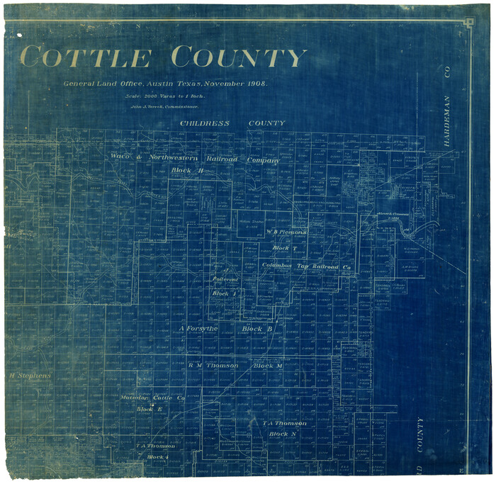
[Northern Portion of] Cottle County
Print $20.00
- Digital $50.00
[Northern Portion of] Cottle County
1908
Size: 28.4 x 29.5 inches
4436
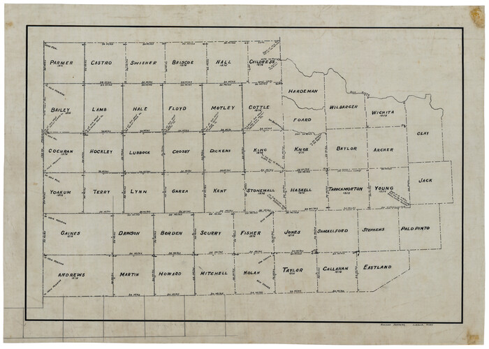
[Map of Counties south of Panhandle]
Print $20.00
- Digital $50.00
[Map of Counties south of Panhandle]
Size: 22.1 x 15.8 inches
92960
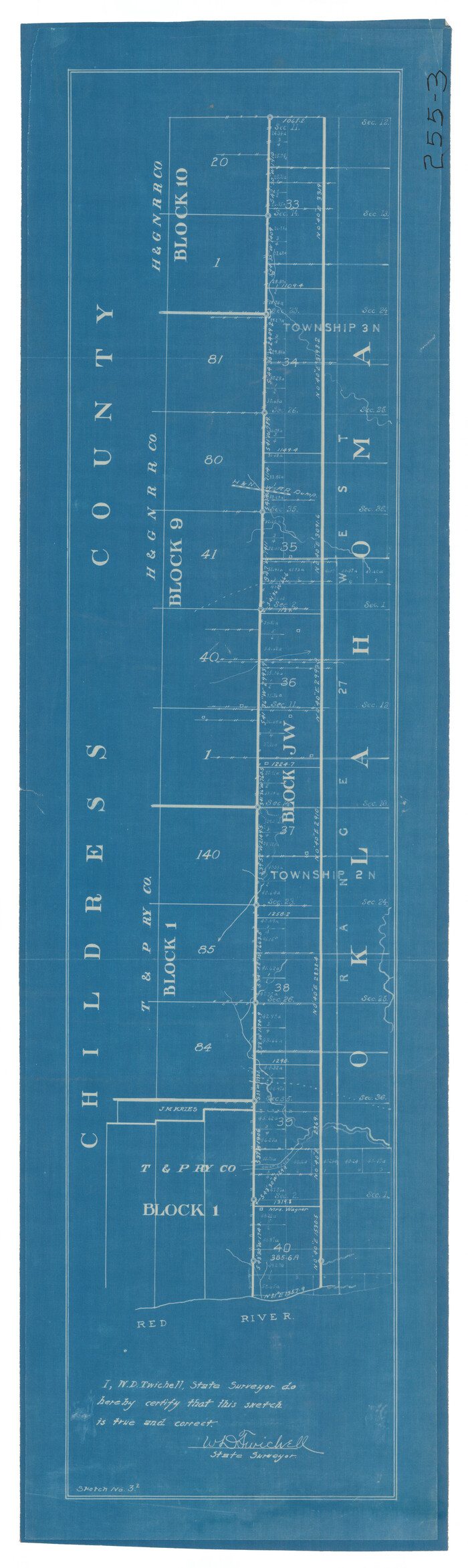
[East line of North Part of Childress County along border with Oklahoma]
Print $20.00
- Digital $50.00
[East line of North Part of Childress County along border with Oklahoma]
Size: 20.4 x 6.1 inches
92084
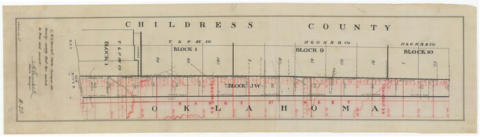
[East line of Childress County along border of Oklahoma]
Print $20.00
- Digital $50.00
[East line of Childress County along border of Oklahoma]
Size: 30.1 x 8.6 inches
91988
Working Sketch in Childress County

Print $20.00
- Digital $50.00
Working Sketch in Childress County
1910
Size: 6.6 x 23.3 inches
90425
Water-Shed of the Pease River Drainage Area

Print $6.00
- Digital $50.00
Water-Shed of the Pease River Drainage Area
Size: 14.9 x 31.0 inches
65102
Texas Panhandle East Boundary Line

Print $20.00
- Digital $50.00
Texas Panhandle East Boundary Line
1898
Size: 32.1 x 8.8 inches
1700
Texas Panhandle East Boundary Line

Print $20.00
- Digital $50.00
Texas Panhandle East Boundary Line
1898
Size: 11.6 x 35.5 inches
1741
Right of Way Map Fort Worth & Denver City Railroad through Hardeman County

Print $40.00
- Digital $50.00
Right of Way Map Fort Worth & Denver City Railroad through Hardeman County
1885
Size: 23.8 x 121.2 inches
64424
Map of the Fort Worth & Denver City Railway

Print $40.00
- Digital $50.00
Map of the Fort Worth & Denver City Railway
1887
Size: 21.7 x 72.8 inches
64479
Map of Childress, Childress County, Texas on the Line of the Fort Worth and Denver City Railway, Texas Pan-Handle Route

Print $20.00
- Digital $50.00
Map of Childress, Childress County, Texas on the Line of the Fort Worth and Denver City Railway, Texas Pan-Handle Route
1888
Size: 35.6 x 28.0 inches
7691
Lipscomb County Sketch File 2

Print $20.00
- Digital $50.00
Lipscomb County Sketch File 2
1902
Size: 10.7 x 8.2 inches
30223
Hardeman County Sketch File 9

Print $20.00
- Digital $50.00
Hardeman County Sketch File 9
1884
Size: 27.7 x 30.1 inches
11624
Hardeman County Sketch File 8a

Print $20.00
- Digital $50.00
Hardeman County Sketch File 8a
Size: 16.0 x 32.0 inches
11623
Hardeman County Sketch File 8

Print $8.00
- Digital $50.00
Hardeman County Sketch File 8
Size: 12.8 x 8.2 inches
25002
Hardeman County Sketch File 7

Print $10.00
- Digital $50.00
Hardeman County Sketch File 7
Size: 8.9 x 14.1 inches
24997
Hardeman County Sketch File 1

Print $20.00
- Digital $50.00
Hardeman County Sketch File 1
Size: 31.0 x 45.7 inches
10477
Hardeman County Rolled Sketch 20

Print $40.00
- Digital $50.00
Hardeman County Rolled Sketch 20
Size: 32.3 x 60.8 inches
9102
Hardeman County Rolled Sketch 17

Print $40.00
- Digital $50.00
Hardeman County Rolled Sketch 17
1888
Size: 57.9 x 31.1 inches
9100
Hardeman County Rolled Sketch 14

Print $40.00
- Digital $50.00
Hardeman County Rolled Sketch 14
1884
Size: 23.9 x 59.2 inches
9099
Hall County Sketch File 5

Print $20.00
- Digital $50.00
Hall County Sketch File 5
1884
Size: 18.9 x 24.1 inches
11602
Hall County Sketch File 29 and 29a

Print $12.00
- Digital $50.00
Hall County Sketch File 29 and 29a
1913
Size: 8.9 x 7.9 inches
24824
Hall County Sketch File 12

Print $20.00
- Digital $50.00
Hall County Sketch File 12
Size: 31.9 x 35.5 inches
10474
Greer County Sketch File 11

Print $6.00
- Digital $50.00
Greer County Sketch File 11
Size: 14.2 x 8.8 inches
24532
General Highway Map, Childress County, Texas

Print $20.00
General Highway Map, Childress County, Texas
1940
Size: 18.3 x 25.2 inches
79046
General Highway Map, Childress County, Texas

Print $20.00
General Highway Map, Childress County, Texas
1961
Size: 18.2 x 24.8 inches
79408
Floyd County Sketch File 25

Print $14.00
- Digital $50.00
Floyd County Sketch File 25
1912
Size: 11.5 x 9.0 inches
22782
Floyd County Sketch File 17

Print $12.00
- Digital $50.00
Floyd County Sketch File 17
1913
Size: 8.3 x 5.4 inches
22747
Cottle County Working Sketch 14a

Print $20.00
- Digital $50.00
Cottle County Working Sketch 14a
1963
Size: 31.2 x 42.1 inches
68324
Cottle County Working Sketch 14B

Print $20.00
- Digital $50.00
Cottle County Working Sketch 14B
1963
Size: 35.2 x 41.6 inches
61795
[Northern Portion of] Cottle County
Print $20.00
- Digital $50.00
[Northern Portion of] Cottle County
1908
-
Size
28.4 x 29.5 inches
-
Map/Doc
4436
-
Creation Date
1908
[Map of Counties south of Panhandle]
Print $20.00
- Digital $50.00
[Map of Counties south of Panhandle]
-
Size
22.1 x 15.8 inches
-
Map/Doc
92960
[East line of North Part of Childress County along border with Oklahoma]
Print $20.00
- Digital $50.00
[East line of North Part of Childress County along border with Oklahoma]
-
Size
20.4 x 6.1 inches
-
Map/Doc
92084
[East line of Childress County along border of Oklahoma]
Print $20.00
- Digital $50.00
[East line of Childress County along border of Oklahoma]
-
Size
30.1 x 8.6 inches
-
Map/Doc
91988
Working Sketch in Childress County
Print $20.00
- Digital $50.00
Working Sketch in Childress County
1910
-
Size
6.6 x 23.3 inches
-
Map/Doc
90425
-
Creation Date
1910
Water-Shed of the Pease River Drainage Area
Print $6.00
- Digital $50.00
Water-Shed of the Pease River Drainage Area
-
Size
14.9 x 31.0 inches
-
Map/Doc
65102
Texas Panhandle East Boundary Line
Print $20.00
- Digital $50.00
Texas Panhandle East Boundary Line
1898
-
Size
32.1 x 8.8 inches
-
Map/Doc
1700
-
Creation Date
1898
Texas Panhandle East Boundary Line
Print $20.00
- Digital $50.00
Texas Panhandle East Boundary Line
1898
-
Size
11.6 x 35.5 inches
-
Map/Doc
1741
-
Creation Date
1898
Right of Way Map Fort Worth & Denver City Railroad through Hardeman County
Print $40.00
- Digital $50.00
Right of Way Map Fort Worth & Denver City Railroad through Hardeman County
1885
-
Size
23.8 x 121.2 inches
-
Map/Doc
64424
-
Creation Date
1885
Map of the Fort Worth & Denver City Railway
Print $40.00
- Digital $50.00
Map of the Fort Worth & Denver City Railway
1887
-
Size
21.7 x 72.8 inches
-
Map/Doc
64479
-
Creation Date
1887
Map of Childress, Childress County, Texas on the Line of the Fort Worth and Denver City Railway, Texas Pan-Handle Route
Print $20.00
- Digital $50.00
Map of Childress, Childress County, Texas on the Line of the Fort Worth and Denver City Railway, Texas Pan-Handle Route
1888
-
Size
35.6 x 28.0 inches
-
Map/Doc
7691
-
Creation Date
1888
Lipscomb County Sketch File 2
Print $20.00
- Digital $50.00
Lipscomb County Sketch File 2
1902
-
Size
10.7 x 8.2 inches
-
Map/Doc
30223
-
Creation Date
1902
Hardeman County Sketch File 9
Print $20.00
- Digital $50.00
Hardeman County Sketch File 9
1884
-
Size
27.7 x 30.1 inches
-
Map/Doc
11624
-
Creation Date
1884
Hardeman County Sketch File 8a
Print $20.00
- Digital $50.00
Hardeman County Sketch File 8a
-
Size
16.0 x 32.0 inches
-
Map/Doc
11623
Hardeman County Sketch File 8
Print $8.00
- Digital $50.00
Hardeman County Sketch File 8
-
Size
12.8 x 8.2 inches
-
Map/Doc
25002
Hardeman County Sketch File 7
Print $10.00
- Digital $50.00
Hardeman County Sketch File 7
-
Size
8.9 x 14.1 inches
-
Map/Doc
24997
Hardeman County Sketch File 1
Print $20.00
- Digital $50.00
Hardeman County Sketch File 1
-
Size
31.0 x 45.7 inches
-
Map/Doc
10477
Hardeman County Rolled Sketch 20
Print $40.00
- Digital $50.00
Hardeman County Rolled Sketch 20
-
Size
32.3 x 60.8 inches
-
Map/Doc
9102
Hardeman County Rolled Sketch 17
Print $40.00
- Digital $50.00
Hardeman County Rolled Sketch 17
1888
-
Size
57.9 x 31.1 inches
-
Map/Doc
9100
-
Creation Date
1888
Hardeman County Rolled Sketch 14
Print $40.00
- Digital $50.00
Hardeman County Rolled Sketch 14
1884
-
Size
23.9 x 59.2 inches
-
Map/Doc
9099
-
Creation Date
1884
Hall County Sketch File 5
Print $20.00
- Digital $50.00
Hall County Sketch File 5
1884
-
Size
18.9 x 24.1 inches
-
Map/Doc
11602
-
Creation Date
1884
Hall County Sketch File 29 and 29a
Print $12.00
- Digital $50.00
Hall County Sketch File 29 and 29a
1913
-
Size
8.9 x 7.9 inches
-
Map/Doc
24824
-
Creation Date
1913
Hall County Sketch File 12
Print $20.00
- Digital $50.00
Hall County Sketch File 12
-
Size
31.9 x 35.5 inches
-
Map/Doc
10474
Greer County Sketch File 11
Print $6.00
- Digital $50.00
Greer County Sketch File 11
-
Size
14.2 x 8.8 inches
-
Map/Doc
24532
General Highway Map, Childress County, Texas
Print $20.00
General Highway Map, Childress County, Texas
1940
-
Size
18.3 x 25.2 inches
-
Map/Doc
79046
-
Creation Date
1940
General Highway Map, Childress County, Texas
Print $20.00
General Highway Map, Childress County, Texas
1961
-
Size
18.2 x 24.8 inches
-
Map/Doc
79408
-
Creation Date
1961
Floyd County Sketch File 25
Print $14.00
- Digital $50.00
Floyd County Sketch File 25
1912
-
Size
11.5 x 9.0 inches
-
Map/Doc
22782
-
Creation Date
1912
Floyd County Sketch File 17
Print $12.00
- Digital $50.00
Floyd County Sketch File 17
1913
-
Size
8.3 x 5.4 inches
-
Map/Doc
22747
-
Creation Date
1913
Cottle County Working Sketch 14a
Print $20.00
- Digital $50.00
Cottle County Working Sketch 14a
1963
-
Size
31.2 x 42.1 inches
-
Map/Doc
68324
-
Creation Date
1963
Cottle County Working Sketch 14B
Print $20.00
- Digital $50.00
Cottle County Working Sketch 14B
1963
-
Size
35.2 x 41.6 inches
-
Map/Doc
61795
-
Creation Date
1963