![4436, [Northern Portion of] Cottle County, Maddox Collection](https://historictexasmaps.com/wmedia_w1800h1800/maps/4436-1.tif.jpg)
[Northern Portion of] Cottle County
-
Map/Doc
4436
-
Collection
Maddox Collection
-
Object Dates
11/1908 (Creation Date)
-
People and Organizations
John J. Terrell (GLO Commissioner)
-
Counties
Cottle Hardeman Childress
-
Height x Width
28.4 x 29.5 inches
72.1 x 74.9 cm
-
Medium
blueprint/diazo
-
Scale
1" = 2000 varas
-
Features
North Pease River
Middle Pease River
School House
Swearingen
Owl Spring
Ranch Camp
QASPRR
Paducah
Part of: Maddox Collection
Sherman County, Texas

Print $20.00
- Digital $50.00
Sherman County, Texas
1888
Size 23.1 x 18.5 inches
Map/Doc 754
[Surveying Sketch of Martha G. Morrow, Mary Bigger, et al in Travis County]
![522, [Surveying Sketch of Martha G. Morrow, Mary Bigger, et al in Travis County], Maddox Collection](https://historictexasmaps.com/wmedia_w700/maps/522.tif.jpg)
Print $3.00
- Digital $50.00
[Surveying Sketch of Martha G. Morrow, Mary Bigger, et al in Travis County]
Size 12.4 x 9.6 inches
Map/Doc 522
[Kenney's sketch of the surveys in Dickens and Motley Counties]

Print $20.00
- Digital $50.00
[Kenney's sketch of the surveys in Dickens and Motley Counties]
1905
Size 20.1 x 15.7 inches
Map/Doc 367
Winkler County, Texas

Print $20.00
- Digital $50.00
Winkler County, Texas
1889
Size 24.6 x 19.0 inches
Map/Doc 658
Saline Ranch in Mason, Kimble and Menard Counties

Print $20.00
- Digital $50.00
Saline Ranch in Mason, Kimble and Menard Counties
1916
Size 28.6 x 27.4 inches
Map/Doc 75808
Map of Brazos County, Texas

Print $20.00
- Digital $50.00
Map of Brazos County, Texas
1879
Size 21.6 x 15.3 inches
Map/Doc 597
[McK. & Williams No. 601 and surrounding surveys, Travis County]
![10782, [McK. & Williams No. 601 and surrounding surveys, Travis County], Maddox Collection](https://historictexasmaps.com/wmedia_w700/maps/10782-1.tif.jpg)
Print $20.00
- Digital $50.00
[McK. & Williams No. 601 and surrounding surveys, Travis County]
Size 18.3 x 12.3 inches
Map/Doc 10782
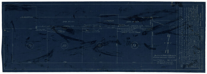
Sketch of Survey 3, Block 1 in Dickens and King Counties
Print $20.00
- Digital $50.00
Sketch of Survey 3, Block 1 in Dickens and King Counties
1914
Size 10.8 x 28.2 inches
Map/Doc 10766
[Joaquin Galan Grant, Webb County]
![583, [Joaquin Galan Grant, Webb County], Maddox Collection](https://historictexasmaps.com/wmedia_w700/maps/583-1.tif.jpg)
Print $20.00
- Digital $50.00
[Joaquin Galan Grant, Webb County]
1882
Size 12.4 x 11.7 inches
Map/Doc 583
Saline Ranch in Mason, Kimble and Menard Counties

Print $20.00
- Digital $50.00
Saline Ranch in Mason, Kimble and Menard Counties
1916
Size 28.3 x 27.2 inches
Map/Doc 75806
Ward County, Texas

Print $20.00
- Digital $50.00
Ward County, Texas
1888
Size 20.2 x 25.5 inches
Map/Doc 657
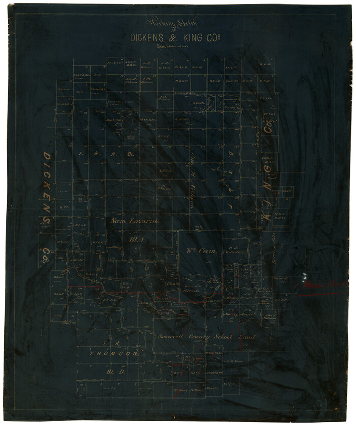
Working Sketch in Dickens & King Cos.
Print $20.00
- Digital $50.00
Working Sketch in Dickens & King Cos.
Size 24.4 x 20.4 inches
Map/Doc 10770
You may also like
Stephens County Working Sketch 7

Print $20.00
- Digital $50.00
Stephens County Working Sketch 7
1919
Size 26.9 x 16.6 inches
Map/Doc 63950
Uvalde County Working Sketch 24

Print $20.00
- Digital $50.00
Uvalde County Working Sketch 24
1954
Size 21.7 x 23.3 inches
Map/Doc 72094
Scurry County

Print $20.00
- Digital $50.00
Scurry County
1921
Size 39.0 x 36.1 inches
Map/Doc 77419
General Highway Map, Jefferson County, Texas

Print $20.00
General Highway Map, Jefferson County, Texas
1961
Size 24.6 x 18.3 inches
Map/Doc 79537
Jeff Davis County Sketch File 21

Print $4.00
- Digital $50.00
Jeff Davis County Sketch File 21
1927
Size 14.1 x 8.8 inches
Map/Doc 27988
Montgomery County Rolled Sketch 13

Print $40.00
- Digital $50.00
Montgomery County Rolled Sketch 13
1932
Size 37.9 x 57.3 inches
Map/Doc 9526
Kimble County Working Sketch 39

Print $20.00
- Digital $50.00
Kimble County Working Sketch 39
1947
Size 30.8 x 23.5 inches
Map/Doc 70107
Upshur County Rolled Sketch 3

Print $20.00
- Digital $50.00
Upshur County Rolled Sketch 3
1965
Size 35.3 x 30.0 inches
Map/Doc 8062
Subdivision of Leagues 21 and 24 McCulloch County School Land Hockley County, Texas

Print $20.00
- Digital $50.00
Subdivision of Leagues 21 and 24 McCulloch County School Land Hockley County, Texas
Size 24.8 x 18.0 inches
Map/Doc 92211
Loving County Working Sketch 16a

Print $20.00
- Digital $50.00
Loving County Working Sketch 16a
1976
Size 45.4 x 29.3 inches
Map/Doc 70650
Flight Mission No. BRE-2P, Frame 64, Nueces County

Print $20.00
- Digital $50.00
Flight Mission No. BRE-2P, Frame 64, Nueces County
1956
Size 18.5 x 22.6 inches
Map/Doc 86759
[Copy from Harris County map]
![78371, [Copy from Harris County map], General Map Collection](https://historictexasmaps.com/wmedia_w700/maps/78371.tif.jpg)
Print $2.00
- Digital $50.00
[Copy from Harris County map]
Size 7.4 x 3.9 inches
Map/Doc 78371