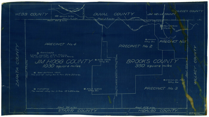
[Sketch showing voting precincts in Jim Hogg and Brooks Counties]
Print $20.00
- Digital $50.00
[Sketch showing voting precincts in Jim Hogg and Brooks Counties]
Size: 10.1 x 18.2 inches
4497
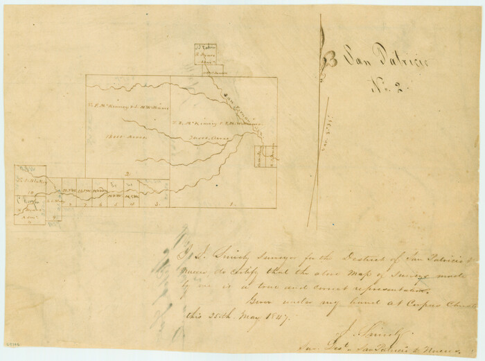
[San Patricio No. 2]
Print $2.00
- Digital $50.00
[San Patricio No. 2]
1847
Size: 8.3 x 11.2 inches
69746
Zapata County Sketch File 1

Print $20.00
- Digital $50.00
Zapata County Sketch File 1
1875
Size: 30.5 x 21.4 inches
12717
Webb County Working Sketch 79

Print $20.00
- Digital $50.00
Webb County Working Sketch 79
1977
Size: 31.0 x 28.3 inches
72446
Webb County Working Sketch 65

Print $40.00
- Digital $50.00
Webb County Working Sketch 65
1964
Size: 49.0 x 59.5 inches
72431
Webb County Working Sketch 28

Print $20.00
- Digital $50.00
Webb County Working Sketch 28
1933
Size: 32.8 x 22.4 inches
72393
Webb County Working Sketch 21

Print $20.00
- Digital $50.00
Webb County Working Sketch 21
1926
Size: 28.7 x 24.7 inches
72386
Webb County Sketch File B2

Print $4.00
- Digital $50.00
Webb County Sketch File B2
1909
Size: 13.9 x 8.1 inches
39656
Webb County Sketch File 9-2

Print $4.00
- Digital $50.00
Webb County Sketch File 9-2
1916
Size: 11.3 x 8.6 inches
39764
Webb County Sketch File 67

Print $20.00
- Digital $50.00
Webb County Sketch File 67
1953
Size: 32.8 x 46.1 inches
10430
Webb County Sketch File 56

Print $20.00
- Digital $50.00
Webb County Sketch File 56
1940
Size: 18.4 x 20.7 inches
12651
Webb County Sketch File 52

Print $40.00
- Digital $50.00
Webb County Sketch File 52
1939
Size: 14.2 x 16.7 inches
39839
Webb County Sketch File 5-1

Print $4.00
- Digital $50.00
Webb County Sketch File 5-1
Size: 3.7 x 12.6 inches
39733
Webb County Sketch File 3-1

Print $20.00
- Digital $50.00
Webb County Sketch File 3-1
1875
Size: 28.0 x 22.8 inches
12614
Webb County Sketch File 2 and 2A

Print $20.00
- Digital $50.00
Webb County Sketch File 2 and 2A
Size: 39.8 x 29.6 inches
10428
Webb County Sketch File 13a

Print $20.00
- Digital $50.00
Webb County Sketch File 13a
1881
Size: 19.0 x 25.7 inches
12631
Webb County Sketch File 10-1

Print $20.00
- Digital $50.00
Webb County Sketch File 10-1
1850
Size: 14.8 x 15.5 inches
12625
Webb County Sketch File 1-2

Print $20.00
- Digital $50.00
Webb County Sketch File 1-2
1912
Size: 21.2 x 22.6 inches
12611
Survey and Location of the Corpus Christi & Rio Grande Railway Under Charter of May 24th 1873

Print $40.00
- Digital $50.00
Survey and Location of the Corpus Christi & Rio Grande Railway Under Charter of May 24th 1873
1874
Size: 12.5 x 58.7 inches
64092
Starr County Sketch File 5

Print $40.00
- Digital $50.00
Starr County Sketch File 5
Size: 31.4 x 40.7 inches
82571
Soil Map - Reconnoissance Survey - South Texas Sheet

Print $20.00
- Digital $50.00
Soil Map - Reconnoissance Survey - South Texas Sheet
1909
Size: 28.6 x 37.8 inches
97267
Oil Development and Structural Map showing Schott, Mirando and other oil fields of the Laredo District with present and proposed development.

Print $20.00
- Digital $50.00
Oil Development and Structural Map showing Schott, Mirando and other oil fields of the Laredo District with present and proposed development.
1920
Size: 11.3 x 8.9 inches
94107
Nueces County Sketch File A

Print $10.00
- Digital $50.00
Nueces County Sketch File A
1879
Size: 14.9 x 10.3 inches
32493
Nueces County Sketch File 6

Print $20.00
- Digital $50.00
Nueces County Sketch File 6
Size: 15.0 x 22.2 inches
42175
Nueces County Sketch File 25

Print $14.00
- Digital $50.00
Nueces County Sketch File 25
1876
Size: 8.7 x 6.3 inches
32572
Nueces County Sketch File 23

Print $36.00
- Digital $50.00
Nueces County Sketch File 23
1886
Size: 11.2 x 8.6 inches
32563
Nueces County Sketch File 14

Print $20.00
- Digital $50.00
Nueces County Sketch File 14
Size: 18.3 x 20.8 inches
42179
Nueces County Sketch File 11

Print $40.00
- Digital $50.00
Nueces County Sketch File 11
1859
Size: 11.2 x 8.6 inches
32518
McMullen County Working Sketch 27

Print $40.00
- Digital $50.00
McMullen County Working Sketch 27
1953
Size: 53.2 x 32.9 inches
70728
McMullen County Working Sketch 14

Print $20.00
- Digital $50.00
McMullen County Working Sketch 14
1938
Size: 28.6 x 37.1 inches
70715
[Sketch showing voting precincts in Jim Hogg and Brooks Counties]
Print $20.00
- Digital $50.00
[Sketch showing voting precincts in Jim Hogg and Brooks Counties]
-
Size
10.1 x 18.2 inches
-
Map/Doc
4497
[San Patricio No. 2]
Print $2.00
- Digital $50.00
[San Patricio No. 2]
1847
-
Size
8.3 x 11.2 inches
-
Map/Doc
69746
-
Creation Date
1847
Zapata County Sketch File 1
Print $20.00
- Digital $50.00
Zapata County Sketch File 1
1875
-
Size
30.5 x 21.4 inches
-
Map/Doc
12717
-
Creation Date
1875
Webb County Working Sketch 79
Print $20.00
- Digital $50.00
Webb County Working Sketch 79
1977
-
Size
31.0 x 28.3 inches
-
Map/Doc
72446
-
Creation Date
1977
Webb County Working Sketch 65
Print $40.00
- Digital $50.00
Webb County Working Sketch 65
1964
-
Size
49.0 x 59.5 inches
-
Map/Doc
72431
-
Creation Date
1964
Webb County Working Sketch 28
Print $20.00
- Digital $50.00
Webb County Working Sketch 28
1933
-
Size
32.8 x 22.4 inches
-
Map/Doc
72393
-
Creation Date
1933
Webb County Working Sketch 21
Print $20.00
- Digital $50.00
Webb County Working Sketch 21
1926
-
Size
28.7 x 24.7 inches
-
Map/Doc
72386
-
Creation Date
1926
Webb County Sketch File B2
Print $4.00
- Digital $50.00
Webb County Sketch File B2
1909
-
Size
13.9 x 8.1 inches
-
Map/Doc
39656
-
Creation Date
1909
Webb County Sketch File 9-2
Print $4.00
- Digital $50.00
Webb County Sketch File 9-2
1916
-
Size
11.3 x 8.6 inches
-
Map/Doc
39764
-
Creation Date
1916
Webb County Sketch File 67
Print $20.00
- Digital $50.00
Webb County Sketch File 67
1953
-
Size
32.8 x 46.1 inches
-
Map/Doc
10430
-
Creation Date
1953
Webb County Sketch File 56
Print $20.00
- Digital $50.00
Webb County Sketch File 56
1940
-
Size
18.4 x 20.7 inches
-
Map/Doc
12651
-
Creation Date
1940
Webb County Sketch File 52
Print $40.00
- Digital $50.00
Webb County Sketch File 52
1939
-
Size
14.2 x 16.7 inches
-
Map/Doc
39839
-
Creation Date
1939
Webb County Sketch File 5-1
Print $4.00
- Digital $50.00
Webb County Sketch File 5-1
-
Size
3.7 x 12.6 inches
-
Map/Doc
39733
Webb County Sketch File 3-1
Print $20.00
- Digital $50.00
Webb County Sketch File 3-1
1875
-
Size
28.0 x 22.8 inches
-
Map/Doc
12614
-
Creation Date
1875
Webb County Sketch File 2 and 2A
Print $20.00
- Digital $50.00
Webb County Sketch File 2 and 2A
-
Size
39.8 x 29.6 inches
-
Map/Doc
10428
Webb County Sketch File 13a
Print $20.00
- Digital $50.00
Webb County Sketch File 13a
1881
-
Size
19.0 x 25.7 inches
-
Map/Doc
12631
-
Creation Date
1881
Webb County Sketch File 10-1
Print $20.00
- Digital $50.00
Webb County Sketch File 10-1
1850
-
Size
14.8 x 15.5 inches
-
Map/Doc
12625
-
Creation Date
1850
Webb County Sketch File 1-2
Print $20.00
- Digital $50.00
Webb County Sketch File 1-2
1912
-
Size
21.2 x 22.6 inches
-
Map/Doc
12611
-
Creation Date
1912
Survey and Location of the Corpus Christi & Rio Grande Railway Under Charter of May 24th 1873
Print $40.00
- Digital $50.00
Survey and Location of the Corpus Christi & Rio Grande Railway Under Charter of May 24th 1873
1874
-
Size
12.5 x 58.7 inches
-
Map/Doc
64092
-
Creation Date
1874
Starr County Sketch File 5
Print $40.00
- Digital $50.00
Starr County Sketch File 5
-
Size
31.4 x 40.7 inches
-
Map/Doc
82571
Soil Map - Reconnoissance Survey - South Texas Sheet
Print $20.00
- Digital $50.00
Soil Map - Reconnoissance Survey - South Texas Sheet
1909
-
Size
28.6 x 37.8 inches
-
Map/Doc
97267
-
Creation Date
1909
Oil Development and Structural Map showing Schott, Mirando and other oil fields of the Laredo District with present and proposed development.
Print $20.00
- Digital $50.00
Oil Development and Structural Map showing Schott, Mirando and other oil fields of the Laredo District with present and proposed development.
1920
-
Size
11.3 x 8.9 inches
-
Map/Doc
94107
-
Creation Date
1920
Nueces County Sketch File A
Print $10.00
- Digital $50.00
Nueces County Sketch File A
1879
-
Size
14.9 x 10.3 inches
-
Map/Doc
32493
-
Creation Date
1879
Nueces County Sketch File 6
Print $20.00
- Digital $50.00
Nueces County Sketch File 6
-
Size
15.0 x 22.2 inches
-
Map/Doc
42175
Nueces County Sketch File 25
Print $14.00
- Digital $50.00
Nueces County Sketch File 25
1876
-
Size
8.7 x 6.3 inches
-
Map/Doc
32572
-
Creation Date
1876
Nueces County Sketch File 23
Print $36.00
- Digital $50.00
Nueces County Sketch File 23
1886
-
Size
11.2 x 8.6 inches
-
Map/Doc
32563
-
Creation Date
1886
Nueces County Sketch File 14
Print $20.00
- Digital $50.00
Nueces County Sketch File 14
-
Size
18.3 x 20.8 inches
-
Map/Doc
42179
Nueces County Sketch File 11
Print $40.00
- Digital $50.00
Nueces County Sketch File 11
1859
-
Size
11.2 x 8.6 inches
-
Map/Doc
32518
-
Creation Date
1859
McMullen County Working Sketch 27
Print $40.00
- Digital $50.00
McMullen County Working Sketch 27
1953
-
Size
53.2 x 32.9 inches
-
Map/Doc
70728
-
Creation Date
1953
McMullen County Working Sketch 14
Print $20.00
- Digital $50.00
McMullen County Working Sketch 14
1938
-
Size
28.6 x 37.1 inches
-
Map/Doc
70715
-
Creation Date
1938