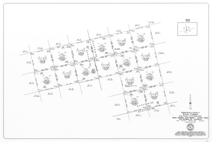
Ector County Working Sketch 34
Print $20.00
- Digital $50.00
Ector County Working Sketch 34
2025
Size: 22.6 x 33.6 inches
97515
Ector County Sketch File 13

Print $16.00
- Digital $50.00
Ector County Sketch File 13
1988
Size: 11.5 x 9.0 inches
21651
Ector County Rolled Sketch 15

Print $20.00
- Digital $50.00
Ector County Rolled Sketch 15
1987
Size: 47.5 x 36.6 inches
8842
Ector County Working Sketch 33

Print $20.00
- Digital $50.00
Ector County Working Sketch 33
1982
Size: 24.7 x 29.0 inches
68876
Ector County Working Sketch 32

Print $20.00
- Digital $50.00
Ector County Working Sketch 32
1981
Size: 26.2 x 17.0 inches
68875
Ector County Working Sketch 31

Print $40.00
- Digital $50.00
Ector County Working Sketch 31
1980
Size: 36.0 x 51.0 inches
68874
Winkler County Working Sketch 18

Print $40.00
- Digital $50.00
Winkler County Working Sketch 18
1980
Size: 33.7 x 49.9 inches
72612
Ector County Working Sketch 29

Print $40.00
- Digital $50.00
Ector County Working Sketch 29
1971
Size: 43.9 x 63.4 inches
68872
Ector County Working Sketch 30

Print $40.00
- Digital $50.00
Ector County Working Sketch 30
1971
Size: 43.2 x 64.1 inches
68873
Ector County Working Sketch 28

Print $40.00
- Digital $50.00
Ector County Working Sketch 28
1971
Size: 43.3 x 61.6 inches
68871
Winkler County Rolled Sketch 11

Print $20.00
- Digital $50.00
Winkler County Rolled Sketch 11
1965
Size: 37.4 x 34.2 inches
10152
Winkler County Rolled Sketch 12

Print $20.00
- Digital $50.00
Winkler County Rolled Sketch 12
1965
Size: 24.9 x 18.5 inches
8279
Winkler County Working Sketch 16

Print $20.00
- Digital $50.00
Winkler County Working Sketch 16
1964
Size: 27.7 x 35.8 inches
72610
Ector County Working Sketch 26

Print $20.00
- Digital $50.00
Ector County Working Sketch 26
1961
Size: 30.8 x 43.6 inches
68869
Ector County Working Sketch 25

Print $20.00
- Digital $50.00
Ector County Working Sketch 25
1961
Size: 29.6 x 34.2 inches
68868
Winkler County Working Sketch 14

Print $20.00
- Digital $50.00
Winkler County Working Sketch 14
1961
Size: 42.9 x 41.4 inches
72608
Ector County Working Sketch 24

Print $40.00
- Digital $50.00
Ector County Working Sketch 24
1961
Size: 42.2 x 51.7 inches
68867
Ector County Working Sketch 23

Print $40.00
- Digital $50.00
Ector County Working Sketch 23
1961
Size: 55.9 x 43.3 inches
68866
General Highway Map, Ector County, Texas

Print $20.00
General Highway Map, Ector County, Texas
1961
Size: 18.0 x 24.8 inches
79451
Winkler County Working Sketch 11

Print $40.00
- Digital $50.00
Winkler County Working Sketch 11
1960
Size: 28.5 x 81.4 inches
72605
Winkler County Working Sketch 10

Print $40.00
- Digital $50.00
Winkler County Working Sketch 10
1960
Size: 30.3 x 61.0 inches
72604
Ector County Working Sketch 22

Print $20.00
- Digital $50.00
Ector County Working Sketch 22
1959
Size: 24.2 x 36.6 inches
68865
Ector County Working Sketch 20

Print $40.00
- Digital $50.00
Ector County Working Sketch 20
1958
Size: 61.5 x 38.4 inches
68863
Ector County Working Sketch 19

Print $40.00
- Digital $50.00
Ector County Working Sketch 19
1958
Size: 65.8 x 37.6 inches
68862
Ector County Rolled Sketch 14

Print $20.00
- Digital $50.00
Ector County Rolled Sketch 14
1957
Size: 38.0 x 31.3 inches
5779
Ector County Rolled Sketch 13

Print $40.00
- Digital $50.00
Ector County Rolled Sketch 13
1957
Size: 49.2 x 32.0 inches
8841
Midland County Working Sketch 24

Print $40.00
- Digital $50.00
Midland County Working Sketch 24
1957
Size: 42.9 x 80.9 inches
71005
Ector County Working Sketch 18

Print $20.00
- Digital $50.00
Ector County Working Sketch 18
1957
Size: 42.0 x 39.1 inches
68861
Ector County Sketch File 12

Print $12.00
- Digital $50.00
Ector County Sketch File 12
1956
Size: 11.4 x 9.0 inches
21645
Ector County Working Sketch 17

Print $40.00
- Digital $50.00
Ector County Working Sketch 17
1956
Size: 59.9 x 24.2 inches
68860
Ector County Working Sketch 34
Print $20.00
- Digital $50.00
Ector County Working Sketch 34
2025
-
Size
22.6 x 33.6 inches
-
Map/Doc
97515
-
Creation Date
2025
Ector County Sketch File 13
Print $16.00
- Digital $50.00
Ector County Sketch File 13
1988
-
Size
11.5 x 9.0 inches
-
Map/Doc
21651
-
Creation Date
1988
Ector County Rolled Sketch 15
Print $20.00
- Digital $50.00
Ector County Rolled Sketch 15
1987
-
Size
47.5 x 36.6 inches
-
Map/Doc
8842
-
Creation Date
1987
Ector County Working Sketch 33
Print $20.00
- Digital $50.00
Ector County Working Sketch 33
1982
-
Size
24.7 x 29.0 inches
-
Map/Doc
68876
-
Creation Date
1982
Ector County Working Sketch 32
Print $20.00
- Digital $50.00
Ector County Working Sketch 32
1981
-
Size
26.2 x 17.0 inches
-
Map/Doc
68875
-
Creation Date
1981
Ector County Working Sketch 31
Print $40.00
- Digital $50.00
Ector County Working Sketch 31
1980
-
Size
36.0 x 51.0 inches
-
Map/Doc
68874
-
Creation Date
1980
Winkler County Working Sketch 18
Print $40.00
- Digital $50.00
Winkler County Working Sketch 18
1980
-
Size
33.7 x 49.9 inches
-
Map/Doc
72612
-
Creation Date
1980
Ector County Working Sketch 29
Print $40.00
- Digital $50.00
Ector County Working Sketch 29
1971
-
Size
43.9 x 63.4 inches
-
Map/Doc
68872
-
Creation Date
1971
Ector County Working Sketch 30
Print $40.00
- Digital $50.00
Ector County Working Sketch 30
1971
-
Size
43.2 x 64.1 inches
-
Map/Doc
68873
-
Creation Date
1971
Ector County Working Sketch 28
Print $40.00
- Digital $50.00
Ector County Working Sketch 28
1971
-
Size
43.3 x 61.6 inches
-
Map/Doc
68871
-
Creation Date
1971
Winkler County Rolled Sketch 11
Print $20.00
- Digital $50.00
Winkler County Rolled Sketch 11
1965
-
Size
37.4 x 34.2 inches
-
Map/Doc
10152
-
Creation Date
1965
Winkler County Rolled Sketch 12
Print $20.00
- Digital $50.00
Winkler County Rolled Sketch 12
1965
-
Size
24.9 x 18.5 inches
-
Map/Doc
8279
-
Creation Date
1965
Winkler County Working Sketch 16
Print $20.00
- Digital $50.00
Winkler County Working Sketch 16
1964
-
Size
27.7 x 35.8 inches
-
Map/Doc
72610
-
Creation Date
1964
Ector County Working Sketch 26
Print $20.00
- Digital $50.00
Ector County Working Sketch 26
1961
-
Size
30.8 x 43.6 inches
-
Map/Doc
68869
-
Creation Date
1961
Ector County Working Sketch 25
Print $20.00
- Digital $50.00
Ector County Working Sketch 25
1961
-
Size
29.6 x 34.2 inches
-
Map/Doc
68868
-
Creation Date
1961
Winkler County Working Sketch 14
Print $20.00
- Digital $50.00
Winkler County Working Sketch 14
1961
-
Size
42.9 x 41.4 inches
-
Map/Doc
72608
-
Creation Date
1961
Ector County Working Sketch 24
Print $40.00
- Digital $50.00
Ector County Working Sketch 24
1961
-
Size
42.2 x 51.7 inches
-
Map/Doc
68867
-
Creation Date
1961
Ector County Working Sketch 23
Print $40.00
- Digital $50.00
Ector County Working Sketch 23
1961
-
Size
55.9 x 43.3 inches
-
Map/Doc
68866
-
Creation Date
1961
General Highway Map, Ector County, Texas
Print $20.00
General Highway Map, Ector County, Texas
1961
-
Size
18.0 x 24.8 inches
-
Map/Doc
79451
-
Creation Date
1961
Winkler County Working Sketch 11
Print $40.00
- Digital $50.00
Winkler County Working Sketch 11
1960
-
Size
28.5 x 81.4 inches
-
Map/Doc
72605
-
Creation Date
1960
Winkler County Working Sketch 10
Print $40.00
- Digital $50.00
Winkler County Working Sketch 10
1960
-
Size
30.3 x 61.0 inches
-
Map/Doc
72604
-
Creation Date
1960
Ector County Working Sketch 22
Print $20.00
- Digital $50.00
Ector County Working Sketch 22
1959
-
Size
24.2 x 36.6 inches
-
Map/Doc
68865
-
Creation Date
1959
Ector County Working Sketch 20
Print $40.00
- Digital $50.00
Ector County Working Sketch 20
1958
-
Size
61.5 x 38.4 inches
-
Map/Doc
68863
-
Creation Date
1958
Ector County Working Sketch 19
Print $40.00
- Digital $50.00
Ector County Working Sketch 19
1958
-
Size
65.8 x 37.6 inches
-
Map/Doc
68862
-
Creation Date
1958
Ector County Rolled Sketch 14
Print $20.00
- Digital $50.00
Ector County Rolled Sketch 14
1957
-
Size
38.0 x 31.3 inches
-
Map/Doc
5779
-
Creation Date
1957
Ector County Rolled Sketch 13
Print $40.00
- Digital $50.00
Ector County Rolled Sketch 13
1957
-
Size
49.2 x 32.0 inches
-
Map/Doc
8841
-
Creation Date
1957
Midland County Working Sketch 24
Print $40.00
- Digital $50.00
Midland County Working Sketch 24
1957
-
Size
42.9 x 80.9 inches
-
Map/Doc
71005
-
Creation Date
1957
Ector County Working Sketch 18
Print $20.00
- Digital $50.00
Ector County Working Sketch 18
1957
-
Size
42.0 x 39.1 inches
-
Map/Doc
68861
-
Creation Date
1957
Ector County Sketch File 12
Print $12.00
- Digital $50.00
Ector County Sketch File 12
1956
-
Size
11.4 x 9.0 inches
-
Map/Doc
21645
-
Creation Date
1956
Ector County Working Sketch 17
Print $40.00
- Digital $50.00
Ector County Working Sketch 17
1956
-
Size
59.9 x 24.2 inches
-
Map/Doc
68860
-
Creation Date
1956