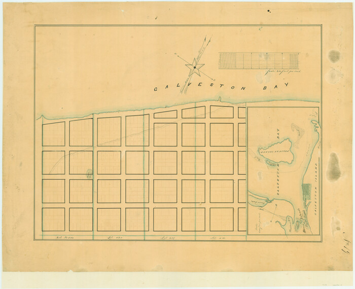
[Town lots on Galveston Island]
Print $20.00
- Digital $50.00
[Town lots on Galveston Island]
1839
Size: 18.8 x 23.0 inches
11
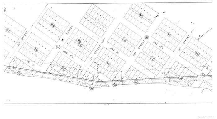
[Map Showing Location and Right of Way of Proposed Groins]
Print $4.00
- Digital $50.00
[Map Showing Location and Right of Way of Proposed Groins]
Size: 13.4 x 24.4 inches
73623
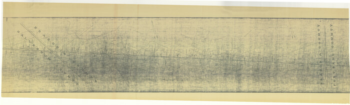
[Gulf, Colorado & Santa Fe]
Print $40.00
- Digital $50.00
[Gulf, Colorado & Santa Fe]
1918
Size: 33.2 x 110.5 inches
64592
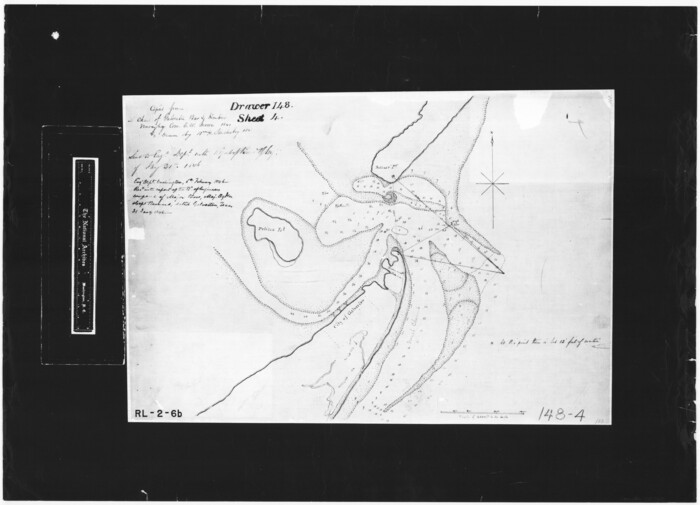
[Copied from a chart of Galveston Bar and Harbor]
Print $20.00
- Digital $50.00
[Copied from a chart of Galveston Bar and Harbor]
1846
Size: 18.3 x 25.3 inches
72760
[Aerial Photograph of Galveston Island and the Gulf of Mexico]
Print $20.00
- Digital $50.00
[Aerial Photograph of Galveston Island and the Gulf of Mexico]
1956
Size: 15.5 x 12.7 inches
83434
[10th St and 29th St Groins - Galveston]
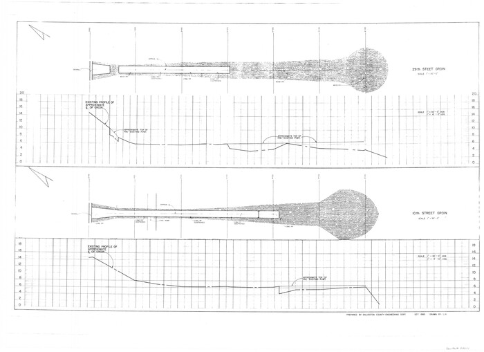
Print $6.00
- Digital $50.00
[10th St and 29th St Groins - Galveston]
1983
Size: 25.6 x 35.2 inches
73621
Visitors' Map of Galveston also showing County Shell Road to Houston

Print $20.00
- Digital $50.00
Visitors' Map of Galveston also showing County Shell Road to Houston
Size: 19.6 x 23.9 inches
95319
Vicinity of San Luis Pass, Galveston Island, Texas

Print $40.00
- Digital $50.00
Vicinity of San Luis Pass, Galveston Island, Texas
1933
Size: 36.9 x 57.2 inches
69942
Vicinity of San Luis Pass, Galveston Island, Texas

Print $40.00
- Digital $50.00
Vicinity of San Luis Pass, Galveston Island, Texas
1933
Size: 37.1 x 57.8 inches
69943
Vicinity map showing railroads serving the ports of Galveston, Houston and Texas City, Texas

Print $20.00
- Digital $50.00
Vicinity map showing railroads serving the ports of Galveston, Houston and Texas City, Texas
1924
Size: 9.3 x 14.8 inches
97164
Upper Galveston Bay, Houston Ship Channel, Dollar Pt. to Atkinson I.

Print $40.00
- Digital $50.00
Upper Galveston Bay, Houston Ship Channel, Dollar Pt. to Atkinson I.
1971
Size: 49.3 x 36.4 inches
69894
Upper Galveston Bay, Houston Ship Channel, Dollar Pt. to Atkinson I.

Print $40.00
- Digital $50.00
Upper Galveston Bay, Houston Ship Channel, Dollar Pt. to Atkinson I.
1972
Size: 49.9 x 36.9 inches
69895
Upper Galveston Bay, Houston Ship Channel, Dollar Pt. to Atkinson I.

Print $40.00
- Digital $50.00
Upper Galveston Bay, Houston Ship Channel, Dollar Pt. to Atkinson I.
1973
Size: 49.8 x 36.8 inches
69896
Upper Galveston Bay, Houston Ship Channel, Dollar Pt. to Atkinson I.

Print $40.00
- Digital $50.00
Upper Galveston Bay, Houston Ship Channel, Dollar Pt. to Atkinson I.
1976
Size: 49.3 x 36.5 inches
69897
Upper Galveston Bay, Houston Ship Channel, Dollar Pt. to Atkinson I.

Print $40.00
- Digital $50.00
Upper Galveston Bay, Houston Ship Channel, Dollar Pt. to Atkinson I.
1978
Size: 49.3 x 36.8 inches
69898
Upper Galveston Bay, Houston Ship Channel, Dollar Pt. to Atkinson I.

Print $40.00
- Digital $50.00
Upper Galveston Bay, Houston Ship Channel, Dollar Pt. to Atkinson I.
1992
Size: 49.2 x 37.0 inches
69899
Topography and water depth as shown by the U.S. Coast Survey of 1888

Print $20.00
- Digital $50.00
Topography and water depth as shown by the U.S. Coast Survey of 1888
1890
Size: 17.0 x 18.8 inches
390
Topography and Water Depth as Shown by the US Coast Survey of 1888

Print $20.00
- Digital $50.00
Topography and Water Depth as Shown by the US Coast Survey of 1888
1890
Size: 16.9 x 18.9 inches
5036
The Republic County of Galveston. January 20, 1841

Print $20.00
The Republic County of Galveston. January 20, 1841
2020
Size: 14.7 x 21.9 inches
96145
The Republic County of Galveston. December 29, 1845

Print $20.00
The Republic County of Galveston. December 29, 1845
2020
Size: 14.7 x 21.9 inches
96146
The Republic County of Galveston. December 16, 1839

Print $20.00
The Republic County of Galveston. December 16, 1839
2020
Size: 14.7 x 21.9 inches
96144
The Republic County of Galveston. Created, May 15, 1838

Print $20.00
The Republic County of Galveston. Created, May 15, 1838
2020
Size: 14.7 x 21.9 inches
96143
Texas Gulf Coast, from the Sabine River to the Rio Grande as Subdivided for Mineral Development; Galveston, Brazoria and Matagorda Counties

Print $40.00
- Digital $50.00
Texas Gulf Coast, from the Sabine River to the Rio Grande as Subdivided for Mineral Development; Galveston, Brazoria and Matagorda Counties
1976
Size: 43.8 x 69.3 inches
1938
Texas Gulf Coast from the Sabine River to the Rio Grande Showing Location of Navigation Districts

Print $20.00
- Digital $50.00
Texas Gulf Coast from the Sabine River to the Rio Grande Showing Location of Navigation Districts
1954
Size: 45.0 x 43.8 inches
73596
Texas Gulf Coast Map from the Sabine River to the Rio Grande as subdivided for mineral development

Print $20.00
- Digital $50.00
Texas Gulf Coast Map from the Sabine River to the Rio Grande as subdivided for mineral development
1966
Size: 29.1 x 41.7 inches
2496
Texas Gulf Coast Map from the Sabine River to the Rio Grande as subdivided for mineral development

Print $40.00
- Digital $50.00
Texas Gulf Coast Map from the Sabine River to the Rio Grande as subdivided for mineral development
1966
Size: 42.8 x 69.7 inches
2497
Texas City. First and Second Division

Print $20.00
- Digital $50.00
Texas City. First and Second Division
1892
Size: 24.3 x 19.1 inches
95355
Texas City Heights being a subdivision of the east half of the Robert Logan one third league, Galveston County, Texas

Print $20.00
- Digital $50.00
Texas City Heights being a subdivision of the east half of the Robert Logan one third league, Galveston County, Texas
1895
Size: 22.4 x 17.3 inches
95356
Survey of all that part of lots 6, 7, and the north 1/2 of 20 foot alley lying south of said lots 6 and 7, all of lots 8, 9, 10, the east one half of lot 11, all of lot 13, lying south and adjacent to the southerly seawall right-of-way line

Print $2.00
- Digital $50.00
Survey of all that part of lots 6, 7, and the north 1/2 of 20 foot alley lying south of said lots 6 and 7, all of lots 8, 9, 10, the east one half of lot 11, all of lot 13, lying south and adjacent to the southerly seawall right-of-way line
1969
Size: 17.0 x 15.3 inches
73624
[Town lots on Galveston Island]
Print $20.00
- Digital $50.00
[Town lots on Galveston Island]
1839
-
Size
18.8 x 23.0 inches
-
Map/Doc
11
-
Creation Date
1839
[Town Plat of Galveston]
![76258, [Town Plat of Galveston], Texas State Library and Archives](https://historictexasmaps.com/wmedia_w700/maps/76258.tif.jpg)
Print $20.00
[Town Plat of Galveston]
1877
-
Size
9.1 x 14.5 inches
-
Map/Doc
76258
-
Creation Date
1877
[Map Showing Location and Right of Way of Proposed Groins]
Print $4.00
- Digital $50.00
[Map Showing Location and Right of Way of Proposed Groins]
-
Size
13.4 x 24.4 inches
-
Map/Doc
73623
[Gulf, Colorado & Santa Fe]
Print $40.00
- Digital $50.00
[Gulf, Colorado & Santa Fe]
1918
-
Size
33.2 x 110.5 inches
-
Map/Doc
64592
-
Creation Date
1918
[Copied from a chart of Galveston Bar and Harbor]
Print $20.00
- Digital $50.00
[Copied from a chart of Galveston Bar and Harbor]
1846
-
Size
18.3 x 25.3 inches
-
Map/Doc
72760
-
Creation Date
1846
[Aerial Photograph of Galveston Island and the Gulf of Mexico]
Print $20.00
- Digital $50.00
[Aerial Photograph of Galveston Island and the Gulf of Mexico]
1956
-
Size
15.5 x 12.7 inches
-
Map/Doc
83434
-
Creation Date
1956
[10th St and 29th St Groins - Galveston]
Print $6.00
- Digital $50.00
[10th St and 29th St Groins - Galveston]
1983
-
Size
25.6 x 35.2 inches
-
Map/Doc
73621
-
Creation Date
1983
Visitors' Map of Galveston also showing County Shell Road to Houston
Print $20.00
- Digital $50.00
Visitors' Map of Galveston also showing County Shell Road to Houston
-
Size
19.6 x 23.9 inches
-
Map/Doc
95319
Vicinity of San Luis Pass, Galveston Island, Texas
Print $40.00
- Digital $50.00
Vicinity of San Luis Pass, Galveston Island, Texas
1933
-
Size
36.9 x 57.2 inches
-
Map/Doc
69942
-
Creation Date
1933
Vicinity of San Luis Pass, Galveston Island, Texas
Print $40.00
- Digital $50.00
Vicinity of San Luis Pass, Galveston Island, Texas
1933
-
Size
37.1 x 57.8 inches
-
Map/Doc
69943
-
Creation Date
1933
Vicinity map showing railroads serving the ports of Galveston, Houston and Texas City, Texas
Print $20.00
- Digital $50.00
Vicinity map showing railroads serving the ports of Galveston, Houston and Texas City, Texas
1924
-
Size
9.3 x 14.8 inches
-
Map/Doc
97164
-
Creation Date
1924
Upper Galveston Bay, Houston Ship Channel, Dollar Pt. to Atkinson I.
Print $40.00
- Digital $50.00
Upper Galveston Bay, Houston Ship Channel, Dollar Pt. to Atkinson I.
1971
-
Size
49.3 x 36.4 inches
-
Map/Doc
69894
-
Creation Date
1971
Upper Galveston Bay, Houston Ship Channel, Dollar Pt. to Atkinson I.
Print $40.00
- Digital $50.00
Upper Galveston Bay, Houston Ship Channel, Dollar Pt. to Atkinson I.
1972
-
Size
49.9 x 36.9 inches
-
Map/Doc
69895
-
Creation Date
1972
Upper Galveston Bay, Houston Ship Channel, Dollar Pt. to Atkinson I.
Print $40.00
- Digital $50.00
Upper Galveston Bay, Houston Ship Channel, Dollar Pt. to Atkinson I.
1973
-
Size
49.8 x 36.8 inches
-
Map/Doc
69896
-
Creation Date
1973
Upper Galveston Bay, Houston Ship Channel, Dollar Pt. to Atkinson I.
Print $40.00
- Digital $50.00
Upper Galveston Bay, Houston Ship Channel, Dollar Pt. to Atkinson I.
1976
-
Size
49.3 x 36.5 inches
-
Map/Doc
69897
-
Creation Date
1976
Upper Galveston Bay, Houston Ship Channel, Dollar Pt. to Atkinson I.
Print $40.00
- Digital $50.00
Upper Galveston Bay, Houston Ship Channel, Dollar Pt. to Atkinson I.
1978
-
Size
49.3 x 36.8 inches
-
Map/Doc
69898
-
Creation Date
1978
Upper Galveston Bay, Houston Ship Channel, Dollar Pt. to Atkinson I.
Print $40.00
- Digital $50.00
Upper Galveston Bay, Houston Ship Channel, Dollar Pt. to Atkinson I.
1992
-
Size
49.2 x 37.0 inches
-
Map/Doc
69899
-
Creation Date
1992
Topography and water depth as shown by the U.S. Coast Survey of 1888
Print $20.00
- Digital $50.00
Topography and water depth as shown by the U.S. Coast Survey of 1888
1890
-
Size
17.0 x 18.8 inches
-
Map/Doc
390
-
Creation Date
1890
Topography and Water Depth as Shown by the US Coast Survey of 1888
Print $20.00
- Digital $50.00
Topography and Water Depth as Shown by the US Coast Survey of 1888
1890
-
Size
16.9 x 18.9 inches
-
Map/Doc
5036
-
Creation Date
1890
The Republic County of Galveston. January 20, 1841
Print $20.00
The Republic County of Galveston. January 20, 1841
2020
-
Size
14.7 x 21.9 inches
-
Map/Doc
96145
-
Creation Date
2020
The Republic County of Galveston. December 29, 1845
Print $20.00
The Republic County of Galveston. December 29, 1845
2020
-
Size
14.7 x 21.9 inches
-
Map/Doc
96146
-
Creation Date
2020
The Republic County of Galveston. December 16, 1839
Print $20.00
The Republic County of Galveston. December 16, 1839
2020
-
Size
14.7 x 21.9 inches
-
Map/Doc
96144
-
Creation Date
2020
The Republic County of Galveston. Created, May 15, 1838
Print $20.00
The Republic County of Galveston. Created, May 15, 1838
2020
-
Size
14.7 x 21.9 inches
-
Map/Doc
96143
-
Creation Date
2020
Texas Gulf Coast, from the Sabine River to the Rio Grande as Subdivided for Mineral Development; Galveston, Brazoria and Matagorda Counties
Print $40.00
- Digital $50.00
Texas Gulf Coast, from the Sabine River to the Rio Grande as Subdivided for Mineral Development; Galveston, Brazoria and Matagorda Counties
1976
-
Size
43.8 x 69.3 inches
-
Map/Doc
1938
-
Creation Date
1976
Texas Gulf Coast from the Sabine River to the Rio Grande Showing Location of Navigation Districts
Print $20.00
- Digital $50.00
Texas Gulf Coast from the Sabine River to the Rio Grande Showing Location of Navigation Districts
1954
-
Size
45.0 x 43.8 inches
-
Map/Doc
73596
-
Creation Date
1954
Texas Gulf Coast Map from the Sabine River to the Rio Grande as subdivided for mineral development
Print $20.00
- Digital $50.00
Texas Gulf Coast Map from the Sabine River to the Rio Grande as subdivided for mineral development
1966
-
Size
29.1 x 41.7 inches
-
Map/Doc
2496
-
Creation Date
1966
Texas Gulf Coast Map from the Sabine River to the Rio Grande as subdivided for mineral development
Print $40.00
- Digital $50.00
Texas Gulf Coast Map from the Sabine River to the Rio Grande as subdivided for mineral development
1966
-
Size
42.8 x 69.7 inches
-
Map/Doc
2497
-
Creation Date
1966
Texas City. First and Second Division
Print $20.00
- Digital $50.00
Texas City. First and Second Division
1892
-
Size
24.3 x 19.1 inches
-
Map/Doc
95355
-
Creation Date
1892
Texas City Heights being a subdivision of the east half of the Robert Logan one third league, Galveston County, Texas
Print $20.00
- Digital $50.00
Texas City Heights being a subdivision of the east half of the Robert Logan one third league, Galveston County, Texas
1895
-
Size
22.4 x 17.3 inches
-
Map/Doc
95356
-
Creation Date
1895
Survey of all that part of lots 6, 7, and the north 1/2 of 20 foot alley lying south of said lots 6 and 7, all of lots 8, 9, 10, the east one half of lot 11, all of lot 13, lying south and adjacent to the southerly seawall right-of-way line
Print $2.00
- Digital $50.00
Survey of all that part of lots 6, 7, and the north 1/2 of 20 foot alley lying south of said lots 6 and 7, all of lots 8, 9, 10, the east one half of lot 11, all of lot 13, lying south and adjacent to the southerly seawall right-of-way line
1969
-
Size
17.0 x 15.3 inches
-
Map/Doc
73624
-
Creation Date
1969