Hockley County Sketch File 3

Print $20.00
- Digital $50.00
Hockley County Sketch File 3
Size: 43.1 x 35.4 inches
10490
Hockley County Sketch File 9

Print $40.00
- Digital $50.00
Hockley County Sketch File 9
1912
Size: 48.2 x 12.8 inches
10491
Capitol Land Reservation

Print $20.00
- Digital $50.00
Capitol Land Reservation
1880
Size: 27.1 x 34.4 inches
10746
Hockley County Sketch File 1

Print $20.00
- Digital $50.00
Hockley County Sketch File 1
Size: 20.3 x 18.9 inches
11767
Hockley County Sketch File 2

Print $20.00
- Digital $50.00
Hockley County Sketch File 2
1900
Size: 13.2 x 18.1 inches
11768
Hockley County Sketch File 6

Print $20.00
- Digital $50.00
Hockley County Sketch File 6
Size: 24.9 x 33.0 inches
11769
Hockley County Sketch File 7

Print $20.00
- Digital $50.00
Hockley County Sketch File 7
Size: 21.0 x 22.5 inches
11770
Hockley County Sketch File 8

Print $20.00
- Digital $50.00
Hockley County Sketch File 8
Size: 35.0 x 26.2 inches
11771
Hockley County Sketch File 12

Print $20.00
- Digital $50.00
Hockley County Sketch File 12
1902
Size: 17.5 x 17.0 inches
11772
Hockley County Sketch File 14

Print $20.00
- Digital $50.00
Hockley County Sketch File 14
1911
Size: 26.5 x 17.5 inches
11773
Hockley County Sketch File 16

Print $20.00
- Digital $50.00
Hockley County Sketch File 16
Size: 23.6 x 30.9 inches
11774
Hockley County Sketch File 19

Print $20.00
- Digital $50.00
Hockley County Sketch File 19
1944
Size: 14.9 x 25.8 inches
11775
Hockley County Sketch File 19a

Print $20.00
- Digital $50.00
Hockley County Sketch File 19a
1944
Size: 15.7 x 25.1 inches
11776
Hockley County Sketch File M

Print $20.00
- Digital $50.00
Hockley County Sketch File M
Size: 22.2 x 25.8 inches
11777
Lamb County Sketch File 5

Print $20.00
- Digital $50.00
Lamb County Sketch File 5
Size: 23.3 x 31.1 inches
11971
Lamb County Sketch File 10

Print $22.00
- Digital $50.00
Lamb County Sketch File 10
1912
Size: 20.0 x 31.2 inches
11972
Lubbock County Sketch File 6

Print $20.00
- Digital $50.00
Lubbock County Sketch File 6
1902
Size: 33.0 x 20.8 inches
12017
Terry County Sketch File 1

Print $20.00
- Digital $50.00
Terry County Sketch File 1
1903
Size: 25.7 x 23.4 inches
12428
Terry County Sketch File 17

Print $5.00
- Digital $50.00
Terry County Sketch File 17
1956
Size: 27.7 x 24.7 inches
12429
Map Showing Resurvey of Capitol Leagues, Lamb, Cochran & Hockley Co's.

Print $20.00
- Digital $50.00
Map Showing Resurvey of Capitol Leagues, Lamb, Cochran & Hockley Co's.
1918
Size: 37.0 x 29.3 inches
1759
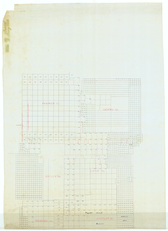
[Map Showing Parmer, Castro, Bailey, Lamb, Cochran & Hockley Counties, Texas]
Print $40.00
- Digital $50.00
[Map Showing Parmer, Castro, Bailey, Lamb, Cochran & Hockley Counties, Texas]
1910
Size: 55.3 x 40.1 inches
1762
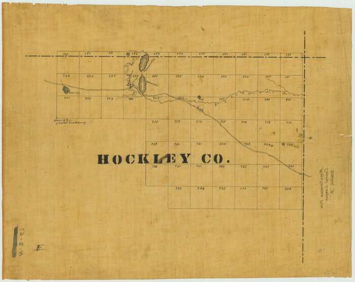
[Capitol League Sketch E, Hockley County]
Print $20.00
- Digital $50.00
[Capitol League Sketch E, Hockley County]
1910
Size: 15.8 x 19.9 inches
1765
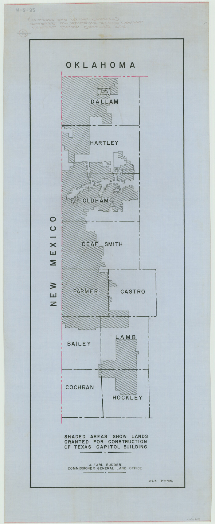
[Capitol lands granted for purpose of building State Capitol]
Print $20.00
- Digital $50.00
[Capitol lands granted for purpose of building State Capitol]
1956
Size: 31.5 x 13.0 inches
2073
Hockley County Sketch File 4

Print $6.00
- Digital $50.00
Hockley County Sketch File 4
Size: 9.1 x 11.2 inches
26536
Hockley County Sketch File 5

Print $4.00
- Digital $50.00
Hockley County Sketch File 5
Size: 9.1 x 11.2 inches
26539
Hockley County Sketch File 10

Print $6.00
- Digital $50.00
Hockley County Sketch File 10
1921
Size: 11.2 x 8.8 inches
26541
Hockley County Sketch File 11

Print $8.00
- Digital $50.00
Hockley County Sketch File 11
Size: 14.3 x 9.0 inches
26544
Hockley County Sketch File 13

Print $4.00
- Digital $50.00
Hockley County Sketch File 13
1914
Size: 8.9 x 10.9 inches
26548
Hockley County Sketch File 3
Print $20.00
- Digital $50.00
Hockley County Sketch File 3
-
Size
43.1 x 35.4 inches
-
Map/Doc
10490
Hockley County Sketch File 9
Print $40.00
- Digital $50.00
Hockley County Sketch File 9
1912
-
Size
48.2 x 12.8 inches
-
Map/Doc
10491
-
Creation Date
1912
Capitol Land Reservation
Print $20.00
- Digital $50.00
Capitol Land Reservation
1880
-
Size
27.1 x 34.4 inches
-
Map/Doc
10746
-
Creation Date
1880
Hockley County Sketch File 1
Print $20.00
- Digital $50.00
Hockley County Sketch File 1
-
Size
20.3 x 18.9 inches
-
Map/Doc
11767
Hockley County Sketch File 2
Print $20.00
- Digital $50.00
Hockley County Sketch File 2
1900
-
Size
13.2 x 18.1 inches
-
Map/Doc
11768
-
Creation Date
1900
Hockley County Sketch File 6
Print $20.00
- Digital $50.00
Hockley County Sketch File 6
-
Size
24.9 x 33.0 inches
-
Map/Doc
11769
Hockley County Sketch File 7
Print $20.00
- Digital $50.00
Hockley County Sketch File 7
-
Size
21.0 x 22.5 inches
-
Map/Doc
11770
Hockley County Sketch File 8
Print $20.00
- Digital $50.00
Hockley County Sketch File 8
-
Size
35.0 x 26.2 inches
-
Map/Doc
11771
Hockley County Sketch File 12
Print $20.00
- Digital $50.00
Hockley County Sketch File 12
1902
-
Size
17.5 x 17.0 inches
-
Map/Doc
11772
-
Creation Date
1902
Hockley County Sketch File 14
Print $20.00
- Digital $50.00
Hockley County Sketch File 14
1911
-
Size
26.5 x 17.5 inches
-
Map/Doc
11773
-
Creation Date
1911
Hockley County Sketch File 16
Print $20.00
- Digital $50.00
Hockley County Sketch File 16
-
Size
23.6 x 30.9 inches
-
Map/Doc
11774
Hockley County Sketch File 19
Print $20.00
- Digital $50.00
Hockley County Sketch File 19
1944
-
Size
14.9 x 25.8 inches
-
Map/Doc
11775
-
Creation Date
1944
Hockley County Sketch File 19a
Print $20.00
- Digital $50.00
Hockley County Sketch File 19a
1944
-
Size
15.7 x 25.1 inches
-
Map/Doc
11776
-
Creation Date
1944
Hockley County Sketch File M
Print $20.00
- Digital $50.00
Hockley County Sketch File M
-
Size
22.2 x 25.8 inches
-
Map/Doc
11777
Lamb County Sketch File 5
Print $20.00
- Digital $50.00
Lamb County Sketch File 5
-
Size
23.3 x 31.1 inches
-
Map/Doc
11971
Lamb County Sketch File 10
Print $22.00
- Digital $50.00
Lamb County Sketch File 10
1912
-
Size
20.0 x 31.2 inches
-
Map/Doc
11972
-
Creation Date
1912
Lubbock County Sketch File 6
Print $20.00
- Digital $50.00
Lubbock County Sketch File 6
1902
-
Size
33.0 x 20.8 inches
-
Map/Doc
12017
-
Creation Date
1902
Terry County Sketch File 1
Print $20.00
- Digital $50.00
Terry County Sketch File 1
1903
-
Size
25.7 x 23.4 inches
-
Map/Doc
12428
-
Creation Date
1903
Terry County Sketch File 17
Print $5.00
- Digital $50.00
Terry County Sketch File 17
1956
-
Size
27.7 x 24.7 inches
-
Map/Doc
12429
-
Creation Date
1956
Hockley County

Print $20.00
- Digital $50.00
Hockley County
1900
-
Size
41.5 x 36.7 inches
-
Map/Doc
16852
-
Creation Date
1900
Map Showing Resurvey of Capitol Leagues, Lamb, Cochran & Hockley Co's.
Print $20.00
- Digital $50.00
Map Showing Resurvey of Capitol Leagues, Lamb, Cochran & Hockley Co's.
1918
-
Size
37.0 x 29.3 inches
-
Map/Doc
1759
-
Creation Date
1918
[Map Showing Parmer, Castro, Bailey, Lamb, Cochran & Hockley Counties, Texas]
Print $40.00
- Digital $50.00
[Map Showing Parmer, Castro, Bailey, Lamb, Cochran & Hockley Counties, Texas]
1910
-
Size
55.3 x 40.1 inches
-
Map/Doc
1762
-
Creation Date
1910
[Capitol League Sketch E, Hockley County]
Print $20.00
- Digital $50.00
[Capitol League Sketch E, Hockley County]
1910
-
Size
15.8 x 19.9 inches
-
Map/Doc
1765
-
Creation Date
1910
Hockley County

Print $20.00
- Digital $50.00
Hockley County
1954
-
Size
42.9 x 38.9 inches
-
Map/Doc
1856
-
Creation Date
1954
[Capitol lands granted for purpose of building State Capitol]
Print $20.00
- Digital $50.00
[Capitol lands granted for purpose of building State Capitol]
1956
-
Size
31.5 x 13.0 inches
-
Map/Doc
2073
-
Creation Date
1956
Hockley County Sketch File 4
Print $6.00
- Digital $50.00
Hockley County Sketch File 4
-
Size
9.1 x 11.2 inches
-
Map/Doc
26536
Hockley County Sketch File 5
Print $4.00
- Digital $50.00
Hockley County Sketch File 5
-
Size
9.1 x 11.2 inches
-
Map/Doc
26539
Hockley County Sketch File 10
Print $6.00
- Digital $50.00
Hockley County Sketch File 10
1921
-
Size
11.2 x 8.8 inches
-
Map/Doc
26541
-
Creation Date
1921
Hockley County Sketch File 11
Print $8.00
- Digital $50.00
Hockley County Sketch File 11
-
Size
14.3 x 9.0 inches
-
Map/Doc
26544
Hockley County Sketch File 13
Print $4.00
- Digital $50.00
Hockley County Sketch File 13
1914
-
Size
8.9 x 10.9 inches
-
Map/Doc
26548
-
Creation Date
1914