Hockley County Working Sketch 4

Print $40.00
- Digital $50.00
Hockley County Working Sketch 4
1973
Size: 38.7 x 52.3 inches
66194
Hockley County Working Sketch 3

Print $20.00
- Digital $50.00
Hockley County Working Sketch 3
1962
Size: 35.4 x 22.0 inches
66193
General Highway Map, Hockley County, Texas

Print $20.00
General Highway Map, Hockley County, Texas
1961
Size: 18.2 x 24.6 inches
79522
Hockley County Working Sketch 2

Print $20.00
- Digital $50.00
Hockley County Working Sketch 2
1960
Size: 17.8 x 35.7 inches
66192
Survey of Improvements on Meeks Gin Site Town of Ropes Hockley County, Texas

Print $20.00
- Digital $50.00
Survey of Improvements on Meeks Gin Site Town of Ropes Hockley County, Texas
1957
Size: 13.0 x 17.6 inches
92214
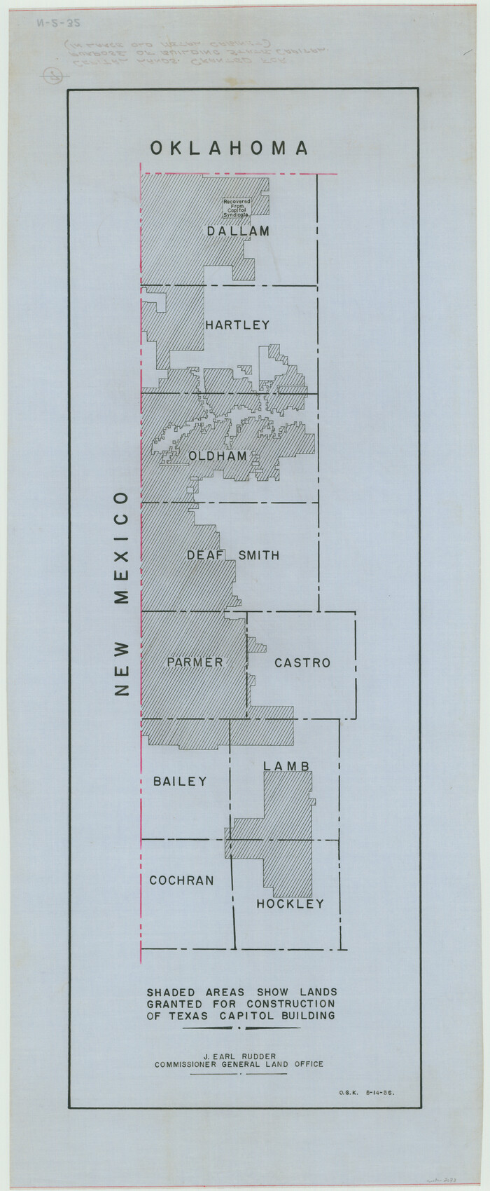
[Capitol lands granted for purpose of building State Capitol]
Print $20.00
- Digital $50.00
[Capitol lands granted for purpose of building State Capitol]
1956
Size: 31.5 x 13.0 inches
2073
Zavalla County School Land Hockley County, Texas

Print $20.00
- Digital $50.00
Zavalla County School Land Hockley County, Texas
1956
Size: 41.6 x 20.2 inches
92254
Terry County Sketch File 17

Print $5.00
- Digital $50.00
Terry County Sketch File 17
1956
Size: 27.7 x 24.7 inches
12429
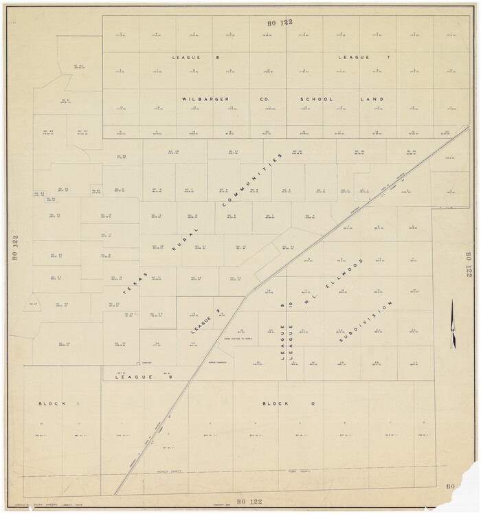
[Sketch showing subdivisions of Leagues 7-10]
Print $20.00
- Digital $50.00
[Sketch showing subdivisions of Leagues 7-10]
1956
Size: 36.6 x 39.4 inches
89850
Plat in Hockley County, Texas

Print $20.00
- Digital $50.00
Plat in Hockley County, Texas
1956
Size: 26.9 x 21.3 inches
92221
Hockley County Working Sketch Graphic Index

Print $20.00
- Digital $50.00
Hockley County Working Sketch Graphic Index
1954
Size: 42.3 x 37.8 inches
76579
Levelland, Hockley County, Texas

Print $20.00
- Digital $50.00
Levelland, Hockley County, Texas
1950
Size: 13.1 x 14.9 inches
92241
General Highway Map Hockley County, Texas

Print $20.00
- Digital $50.00
General Highway Map Hockley County, Texas
1949
Size: 25.7 x 18.8 inches
92209
Spade Ranch Hockley County, Texas

Print $20.00
- Digital $50.00
Spade Ranch Hockley County, Texas
1948
Size: 14.2 x 19.0 inches
92225
Spade Ranch Hockley County, Texas

Print $3.00
- Digital $50.00
Spade Ranch Hockley County, Texas
1948
Size: 17.6 x 7.7 inches
92226
Hockley County Rolled Sketch 9

Print $20.00
- Digital $50.00
Hockley County Rolled Sketch 9
1947
Size: 21.2 x 16.5 inches
6218
Plat Showing Subdivision of Howard County School Land Hockley County, Texas

Print $20.00
- Digital $50.00
Plat Showing Subdivision of Howard County School Land Hockley County, Texas
1947
Size: 13.9 x 28.1 inches
92256
Plat Showing Subdivision of Wilbarger County School Land Hockley County, Texas

Print $20.00
- Digital $50.00
Plat Showing Subdivision of Wilbarger County School Land Hockley County, Texas
1947
Size: 20.0 x 20.9 inches
92255
Hockley County Sketch, Mineral Application Number 39180

Print $3.00
- Digital $50.00
Hockley County Sketch, Mineral Application Number 39180
1947
Size: 10.4 x 12.8 inches
91106
Hockley County Sketch Mineral Application Number 39180

Print $20.00
- Digital $50.00
Hockley County Sketch Mineral Application Number 39180
1947
Size: 16.1 x 20.1 inches
92246
Hockley County Rolled Sketch 8

Print $20.00
- Digital $50.00
Hockley County Rolled Sketch 8
1946
Size: 25.1 x 38.0 inches
6217
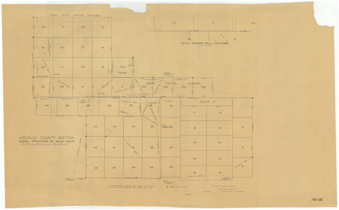
[Hockley County Sketch, Mineral Application Number 38322- 38379]
Print $20.00
- Digital $50.00
[Hockley County Sketch, Mineral Application Number 38322- 38379]
1946
Size: 43.5 x 26.7 inches
91203
Hockley County Sketch Mineral Applications Number 38322- 38379

Print $20.00
- Digital $50.00
Hockley County Sketch Mineral Applications Number 38322- 38379
1946
Size: 33.5 x 27.9 inches
92232
Hockley County Sketch Mineral Application Number 38322- 38379

Print $20.00
- Digital $50.00
Hockley County Sketch Mineral Application Number 38322- 38379
1946
Size: 34.1 x 27.8 inches
92242
Hockley County Working Sketch 1

Print $40.00
- Digital $50.00
Hockley County Working Sketch 1
1946
Size: 26.0 x 60.9 inches
66191
Hockley County Sketch Mineral Application Number 38245

Print $20.00
- Digital $50.00
Hockley County Sketch Mineral Application Number 38245
1946
Size: 40.6 x 18.5 inches
92243
Hockley County Working Sketch 4
Print $40.00
- Digital $50.00
Hockley County Working Sketch 4
1973
-
Size
38.7 x 52.3 inches
-
Map/Doc
66194
-
Creation Date
1973
Hockley County Working Sketch 3
Print $20.00
- Digital $50.00
Hockley County Working Sketch 3
1962
-
Size
35.4 x 22.0 inches
-
Map/Doc
66193
-
Creation Date
1962
General Highway Map, Hockley County, Texas
Print $20.00
General Highway Map, Hockley County, Texas
1961
-
Size
18.2 x 24.6 inches
-
Map/Doc
79522
-
Creation Date
1961
Hockley County Working Sketch 2
Print $20.00
- Digital $50.00
Hockley County Working Sketch 2
1960
-
Size
17.8 x 35.7 inches
-
Map/Doc
66192
-
Creation Date
1960
Survey of Improvements on Meeks Gin Site Town of Ropes Hockley County, Texas
Print $20.00
- Digital $50.00
Survey of Improvements on Meeks Gin Site Town of Ropes Hockley County, Texas
1957
-
Size
13.0 x 17.6 inches
-
Map/Doc
92214
-
Creation Date
1957
[Capitol lands granted for purpose of building State Capitol]
Print $20.00
- Digital $50.00
[Capitol lands granted for purpose of building State Capitol]
1956
-
Size
31.5 x 13.0 inches
-
Map/Doc
2073
-
Creation Date
1956
Zavalla County School Land Hockley County, Texas
Print $20.00
- Digital $50.00
Zavalla County School Land Hockley County, Texas
1956
-
Size
41.6 x 20.2 inches
-
Map/Doc
92254
-
Creation Date
1956
Terry County Sketch File 17
Print $5.00
- Digital $50.00
Terry County Sketch File 17
1956
-
Size
27.7 x 24.7 inches
-
Map/Doc
12429
-
Creation Date
1956
[Sketch showing subdivisions of Leagues 7-10]
Print $20.00
- Digital $50.00
[Sketch showing subdivisions of Leagues 7-10]
1956
-
Size
36.6 x 39.4 inches
-
Map/Doc
89850
-
Creation Date
1956
Plat in Hockley County, Texas
Print $20.00
- Digital $50.00
Plat in Hockley County, Texas
1956
-
Size
26.9 x 21.3 inches
-
Map/Doc
92221
-
Creation Date
1956
Hockley County

Print $20.00
- Digital $50.00
Hockley County
1954
-
Size
42.9 x 38.9 inches
-
Map/Doc
1856
-
Creation Date
1954
Hockley County

Print $20.00
- Digital $50.00
Hockley County
1954
-
Size
42.7 x 38.2 inches
-
Map/Doc
73181
-
Creation Date
1954
Hockley County Working Sketch Graphic Index
Print $20.00
- Digital $50.00
Hockley County Working Sketch Graphic Index
1954
-
Size
42.3 x 37.8 inches
-
Map/Doc
76579
-
Creation Date
1954
Hockley County

Print $20.00
- Digital $50.00
Hockley County
1954
-
Size
41.0 x 36.4 inches
-
Map/Doc
77313
-
Creation Date
1954
Hockley County

Print $20.00
- Digital $50.00
Hockley County
1954
-
Size
44.2 x 39.7 inches
-
Map/Doc
95531
-
Creation Date
1954
Levelland, Hockley County, Texas
Print $20.00
- Digital $50.00
Levelland, Hockley County, Texas
1950
-
Size
13.1 x 14.9 inches
-
Map/Doc
92241
-
Creation Date
1950
General Highway Map Hockley County, Texas
Print $20.00
- Digital $50.00
General Highway Map Hockley County, Texas
1949
-
Size
25.7 x 18.8 inches
-
Map/Doc
92209
-
Creation Date
1949
Spade Ranch Hockley County, Texas
Print $20.00
- Digital $50.00
Spade Ranch Hockley County, Texas
1948
-
Size
14.2 x 19.0 inches
-
Map/Doc
92225
-
Creation Date
1948
Spade Ranch Hockley County, Texas
Print $3.00
- Digital $50.00
Spade Ranch Hockley County, Texas
1948
-
Size
17.6 x 7.7 inches
-
Map/Doc
92226
-
Creation Date
1948
Hockley County Rolled Sketch 9
Print $20.00
- Digital $50.00
Hockley County Rolled Sketch 9
1947
-
Size
21.2 x 16.5 inches
-
Map/Doc
6218
-
Creation Date
1947
Plat Showing Subdivision of Howard County School Land Hockley County, Texas
Print $20.00
- Digital $50.00
Plat Showing Subdivision of Howard County School Land Hockley County, Texas
1947
-
Size
13.9 x 28.1 inches
-
Map/Doc
92256
-
Creation Date
1947
Plat Showing Subdivision of Wilbarger County School Land Hockley County, Texas
Print $20.00
- Digital $50.00
Plat Showing Subdivision of Wilbarger County School Land Hockley County, Texas
1947
-
Size
20.0 x 20.9 inches
-
Map/Doc
92255
-
Creation Date
1947
Hockley County Sketch, Mineral Application Number 39180
Print $3.00
- Digital $50.00
Hockley County Sketch, Mineral Application Number 39180
1947
-
Size
10.4 x 12.8 inches
-
Map/Doc
91106
-
Creation Date
1947
Hockley County Sketch Mineral Application Number 39180
Print $20.00
- Digital $50.00
Hockley County Sketch Mineral Application Number 39180
1947
-
Size
16.1 x 20.1 inches
-
Map/Doc
92246
-
Creation Date
1947
Hockley County Rolled Sketch 8
Print $20.00
- Digital $50.00
Hockley County Rolled Sketch 8
1946
-
Size
25.1 x 38.0 inches
-
Map/Doc
6217
-
Creation Date
1946
[Hockley County Sketch, Mineral Application Number 38322- 38379]
Print $20.00
- Digital $50.00
[Hockley County Sketch, Mineral Application Number 38322- 38379]
1946
-
Size
43.5 x 26.7 inches
-
Map/Doc
91203
-
Creation Date
1946
Hockley County Sketch Mineral Applications Number 38322- 38379
Print $20.00
- Digital $50.00
Hockley County Sketch Mineral Applications Number 38322- 38379
1946
-
Size
33.5 x 27.9 inches
-
Map/Doc
92232
-
Creation Date
1946
Hockley County Sketch Mineral Application Number 38322- 38379
Print $20.00
- Digital $50.00
Hockley County Sketch Mineral Application Number 38322- 38379
1946
-
Size
34.1 x 27.8 inches
-
Map/Doc
92242
-
Creation Date
1946
Hockley County Working Sketch 1
Print $40.00
- Digital $50.00
Hockley County Working Sketch 1
1946
-
Size
26.0 x 60.9 inches
-
Map/Doc
66191
-
Creation Date
1946
Hockley County Sketch Mineral Application Number 38245
Print $20.00
- Digital $50.00
Hockley County Sketch Mineral Application Number 38245
1946
-
Size
40.6 x 18.5 inches
-
Map/Doc
92243
-
Creation Date
1946