[Surveys in Hopkins and Wood Counties]
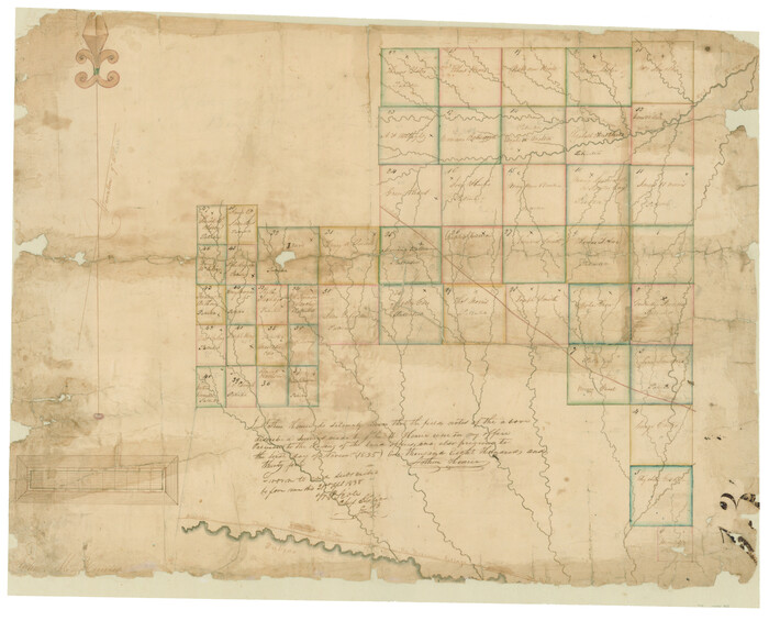
Print $20.00
- Digital $50.00
[Surveys in Hopkins and Wood Counties]
1838
Size: 24.7 x 31.7 inches
365
[St. Louis & Southwestern]
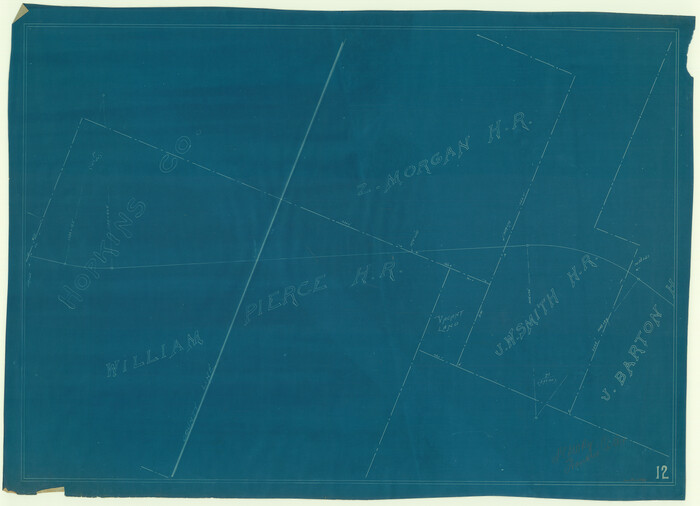
Print $20.00
- Digital $50.00
[St. Louis & Southwestern]
Size: 20.9 x 29.0 inches
64281
[South part of Lamar County]
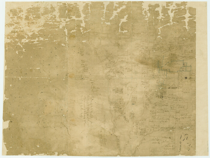
Print $20.00
- Digital $50.00
[South part of Lamar County]
1844
Size: 15.5 x 20.5 inches
76045
[East Line & Red River Railroad from Sulphur Springs to Jefferson]
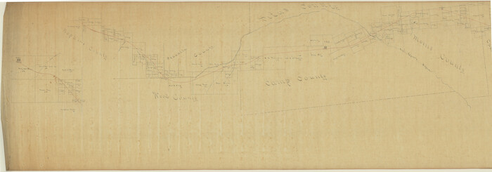
Print $40.00
- Digital $50.00
[East Line & Red River Railroad from Sulphur Springs to Jefferson]
1879
Size: 38.0 x 108.5 inches
64768
Wood County Working Sketch 23

Print $40.00
- Digital $50.00
Wood County Working Sketch 23
1962
Size: 54.9 x 43.5 inches
78230
Wood County Working Sketch 22

Print $20.00
- Digital $50.00
Wood County Working Sketch 22
1962
Size: 45.9 x 36.6 inches
62022
Wood County Working Sketch 21

Print $20.00
- Digital $50.00
Wood County Working Sketch 21
1962
Size: 40.6 x 35.7 inches
62021
Wood County Sketch File 2

Print $4.00
- Digital $50.00
Wood County Sketch File 2
1848
Size: 8.3 x 6.4 inches
40631
Wood County Rolled Sketch 7

Print $20.00
- Digital $50.00
Wood County Rolled Sketch 7
Size: 31.9 x 26.9 inches
8285
Wood County Rolled Sketch 10

Print $20.00
- Digital $50.00
Wood County Rolled Sketch 10
Size: 30.1 x 26.1 inches
76416
Water-Shed of the Sulphur River in Texas Drainage Area

Print $4.00
- Digital $50.00
Water-Shed of the Sulphur River in Texas Drainage Area
1925
Size: 16.6 x 28.4 inches
65154
Sulphur River, Ringo Crossing Sheet

Print $20.00
- Digital $50.00
Sulphur River, Ringo Crossing Sheet
1933
Size: 30.5 x 35.9 inches
65162
Sulphur River, Ringo Crossing Sheet

Print $20.00
- Digital $50.00
Sulphur River, Ringo Crossing Sheet
1933
Size: 18.5 x 20.4 inches
78334
South Sulphur River, Klondike Sheet

Print $6.00
- Digital $50.00
South Sulphur River, Klondike Sheet
1925
Size: 32.2 x 35.5 inches
65170
South Sulphur River, Klondike Sheet

Print $20.00
- Digital $50.00
South Sulphur River, Klondike Sheet
1925
Size: 18.2 x 19.9 inches
78332
South Sulphur River, Harpers Crossing Sheet

Print $20.00
- Digital $50.00
South Sulphur River, Harpers Crossing Sheet
1925
Size: 42.2 x 29.2 inches
65169
South Sulphur River, Harpers Crossing Sheet

Print $20.00
- Digital $50.00
South Sulphur River, Harpers Crossing Sheet
1925
Size: 23.3 x 18.0 inches
78328
South Sulphur River, Charleston Sheet

Print $4.00
- Digital $50.00
South Sulphur River, Charleston Sheet
1924
Size: 29.4 x 29.5 inches
65168
South Sulphur River, Charleston Sheet

Print $20.00
- Digital $50.00
South Sulphur River, Charleston Sheet
1924
Size: 16.6 x 18.0 inches
78326
South Sulphur River, Bonner Point Sheet

Print $20.00
- Digital $50.00
South Sulphur River, Bonner Point Sheet
1922
Size: 32.9 x 35.7 inches
65164
Sabine River, Watershed of the Sabine and Neches Rivers

Print $20.00
- Digital $50.00
Sabine River, Watershed of the Sabine and Neches Rivers
Size: 39.5 x 36.0 inches
65132
Right of Way and Track Map of The Missouri, Kansas & Texas Railway of Texas

Print $40.00
- Digital $50.00
Right of Way and Track Map of The Missouri, Kansas & Texas Railway of Texas
1918
Size: 25.6 x 52.6 inches
64525
Right of Way and Track Map of The Missouri, Kansas & Texas Railway of Texas

Print $40.00
- Digital $50.00
Right of Way and Track Map of The Missouri, Kansas & Texas Railway of Texas
1918
Size: 25.9 x 108.3 inches
64526
Right of Way and Track Map of The Missouri, Kansas & Texas Railway of Texas

Print $40.00
- Digital $50.00
Right of Way and Track Map of The Missouri, Kansas & Texas Railway of Texas
1918
Size: 25.3 x 56.1 inches
64528
Right of Way and Track Map of The Missouri, Kansas & Texas Railway of Texas

Print $40.00
- Digital $50.00
Right of Way and Track Map of The Missouri, Kansas & Texas Railway of Texas
1918
Size: 24.8 x 52.6 inches
64529
Right of Way and Track Map of The Missouri, Kansas & Texas Railway of Texas

Print $40.00
- Digital $50.00
Right of Way and Track Map of The Missouri, Kansas & Texas Railway of Texas
1918
Size: 25.2 x 51.6 inches
64530
Right of Way and Track Map of The Missouri, Kansas & Texas Railway of Texas

Print $40.00
- Digital $50.00
Right of Way and Track Map of The Missouri, Kansas & Texas Railway of Texas
1918
Size: 25.2 x 106.9 inches
64531
Right of Way and Track Map of The Missouri, Kansas & Texas Railway of Texas

Print $40.00
- Digital $50.00
Right of Way and Track Map of The Missouri, Kansas & Texas Railway of Texas
1918
Size: 25.7 x 107.8 inches
64532
Right of Way and Track Map of The Missouri, Kansas & Texas Railway of Texas

Print $40.00
- Digital $50.00
Right of Way and Track Map of The Missouri, Kansas & Texas Railway of Texas
1918
Size: 25.4 x 75.5 inches
64533
Right of Way and Track Map for The Missouri, Kansas & Texas Railway of Texas

Print $40.00
- Digital $50.00
Right of Way and Track Map for The Missouri, Kansas & Texas Railway of Texas
1918
Size: 25.9 x 56.0 inches
64527
[Surveys in Hopkins and Wood Counties]
Print $20.00
- Digital $50.00
[Surveys in Hopkins and Wood Counties]
1838
-
Size
24.7 x 31.7 inches
-
Map/Doc
365
-
Creation Date
1838
[St. Louis & Southwestern]
Print $20.00
- Digital $50.00
[St. Louis & Southwestern]
-
Size
20.9 x 29.0 inches
-
Map/Doc
64281
[South part of Lamar County]
Print $20.00
- Digital $50.00
[South part of Lamar County]
1844
-
Size
15.5 x 20.5 inches
-
Map/Doc
76045
-
Creation Date
1844
[East Line & Red River Railroad from Sulphur Springs to Jefferson]
Print $40.00
- Digital $50.00
[East Line & Red River Railroad from Sulphur Springs to Jefferson]
1879
-
Size
38.0 x 108.5 inches
-
Map/Doc
64768
-
Creation Date
1879
Wood County Working Sketch 23
Print $40.00
- Digital $50.00
Wood County Working Sketch 23
1962
-
Size
54.9 x 43.5 inches
-
Map/Doc
78230
-
Creation Date
1962
Wood County Working Sketch 22
Print $20.00
- Digital $50.00
Wood County Working Sketch 22
1962
-
Size
45.9 x 36.6 inches
-
Map/Doc
62022
-
Creation Date
1962
Wood County Working Sketch 21
Print $20.00
- Digital $50.00
Wood County Working Sketch 21
1962
-
Size
40.6 x 35.7 inches
-
Map/Doc
62021
-
Creation Date
1962
Wood County Sketch File 2
Print $4.00
- Digital $50.00
Wood County Sketch File 2
1848
-
Size
8.3 x 6.4 inches
-
Map/Doc
40631
-
Creation Date
1848
Wood County Rolled Sketch 7
Print $20.00
- Digital $50.00
Wood County Rolled Sketch 7
-
Size
31.9 x 26.9 inches
-
Map/Doc
8285
Wood County Rolled Sketch 10
Print $20.00
- Digital $50.00
Wood County Rolled Sketch 10
-
Size
30.1 x 26.1 inches
-
Map/Doc
76416
Water-Shed of the Sulphur River in Texas Drainage Area
Print $4.00
- Digital $50.00
Water-Shed of the Sulphur River in Texas Drainage Area
1925
-
Size
16.6 x 28.4 inches
-
Map/Doc
65154
-
Creation Date
1925
Sulphur River, Ringo Crossing Sheet
Print $20.00
- Digital $50.00
Sulphur River, Ringo Crossing Sheet
1933
-
Size
30.5 x 35.9 inches
-
Map/Doc
65162
-
Creation Date
1933
Sulphur River, Ringo Crossing Sheet
Print $20.00
- Digital $50.00
Sulphur River, Ringo Crossing Sheet
1933
-
Size
18.5 x 20.4 inches
-
Map/Doc
78334
-
Creation Date
1933
South Sulphur River, Klondike Sheet
Print $6.00
- Digital $50.00
South Sulphur River, Klondike Sheet
1925
-
Size
32.2 x 35.5 inches
-
Map/Doc
65170
-
Creation Date
1925
South Sulphur River, Klondike Sheet
Print $20.00
- Digital $50.00
South Sulphur River, Klondike Sheet
1925
-
Size
18.2 x 19.9 inches
-
Map/Doc
78332
-
Creation Date
1925
South Sulphur River, Harpers Crossing Sheet
Print $20.00
- Digital $50.00
South Sulphur River, Harpers Crossing Sheet
1925
-
Size
42.2 x 29.2 inches
-
Map/Doc
65169
-
Creation Date
1925
South Sulphur River, Harpers Crossing Sheet
Print $20.00
- Digital $50.00
South Sulphur River, Harpers Crossing Sheet
1925
-
Size
23.3 x 18.0 inches
-
Map/Doc
78328
-
Creation Date
1925
South Sulphur River, Charleston Sheet
Print $4.00
- Digital $50.00
South Sulphur River, Charleston Sheet
1924
-
Size
29.4 x 29.5 inches
-
Map/Doc
65168
-
Creation Date
1924
South Sulphur River, Charleston Sheet
Print $20.00
- Digital $50.00
South Sulphur River, Charleston Sheet
1924
-
Size
16.6 x 18.0 inches
-
Map/Doc
78326
-
Creation Date
1924
South Sulphur River, Bonner Point Sheet
Print $20.00
- Digital $50.00
South Sulphur River, Bonner Point Sheet
1922
-
Size
32.9 x 35.7 inches
-
Map/Doc
65164
-
Creation Date
1922
Sabine River, Watershed of the Sabine and Neches Rivers
Print $20.00
- Digital $50.00
Sabine River, Watershed of the Sabine and Neches Rivers
-
Size
39.5 x 36.0 inches
-
Map/Doc
65132
Right of Way and Track Map of The Missouri, Kansas & Texas Railway of Texas
Print $40.00
- Digital $50.00
Right of Way and Track Map of The Missouri, Kansas & Texas Railway of Texas
1918
-
Size
25.6 x 52.6 inches
-
Map/Doc
64525
-
Creation Date
1918
Right of Way and Track Map of The Missouri, Kansas & Texas Railway of Texas
Print $40.00
- Digital $50.00
Right of Way and Track Map of The Missouri, Kansas & Texas Railway of Texas
1918
-
Size
25.9 x 108.3 inches
-
Map/Doc
64526
-
Creation Date
1918
Right of Way and Track Map of The Missouri, Kansas & Texas Railway of Texas
Print $40.00
- Digital $50.00
Right of Way and Track Map of The Missouri, Kansas & Texas Railway of Texas
1918
-
Size
25.3 x 56.1 inches
-
Map/Doc
64528
-
Creation Date
1918
Right of Way and Track Map of The Missouri, Kansas & Texas Railway of Texas
Print $40.00
- Digital $50.00
Right of Way and Track Map of The Missouri, Kansas & Texas Railway of Texas
1918
-
Size
24.8 x 52.6 inches
-
Map/Doc
64529
-
Creation Date
1918
Right of Way and Track Map of The Missouri, Kansas & Texas Railway of Texas
Print $40.00
- Digital $50.00
Right of Way and Track Map of The Missouri, Kansas & Texas Railway of Texas
1918
-
Size
25.2 x 51.6 inches
-
Map/Doc
64530
-
Creation Date
1918
Right of Way and Track Map of The Missouri, Kansas & Texas Railway of Texas
Print $40.00
- Digital $50.00
Right of Way and Track Map of The Missouri, Kansas & Texas Railway of Texas
1918
-
Size
25.2 x 106.9 inches
-
Map/Doc
64531
-
Creation Date
1918
Right of Way and Track Map of The Missouri, Kansas & Texas Railway of Texas
Print $40.00
- Digital $50.00
Right of Way and Track Map of The Missouri, Kansas & Texas Railway of Texas
1918
-
Size
25.7 x 107.8 inches
-
Map/Doc
64532
-
Creation Date
1918
Right of Way and Track Map of The Missouri, Kansas & Texas Railway of Texas
Print $40.00
- Digital $50.00
Right of Way and Track Map of The Missouri, Kansas & Texas Railway of Texas
1918
-
Size
25.4 x 75.5 inches
-
Map/Doc
64533
-
Creation Date
1918
Right of Way and Track Map for The Missouri, Kansas & Texas Railway of Texas
Print $40.00
- Digital $50.00
Right of Way and Track Map for The Missouri, Kansas & Texas Railway of Texas
1918
-
Size
25.9 x 56.0 inches
-
Map/Doc
64527
-
Creation Date
1918